National Register of Historic Places listings in Marion County, Texas
List of Registered Historic Places in Marion County, Texas
This is intended to be a complete list of properties and districts listed on the National Register of Historic Places in Marion County, Texas. The locations of National Register properties and districts (at least for all showing latitude and longitude coordinates below) may be seen in a map by clicking on "Map of all coordinates".[1]
- This National Park Service list is complete through NPS recent listings posted December 2, 2016.[2]
| [3] |
Name on the Register[4] |
Image |
Date listed[5] |
Location |
City or town |
Description |
|---|
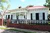
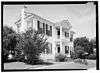
| 1 |
Alley-Carlson House |
|
000000001969-10-28-0000October 28, 1969
(#69000206) |
501 Walker St.
32°45′34″N 94°21′00″W / 32.759444°N 94.35°W / 32.759444; -94.35 (Alley-Carlson House) |
Jefferson |
|
| 2 |
Birge-Beard House |
|
000000001970-08-25-0000August 25, 1970
(#70000754) |
212 N. Vale St.
32°45′27″N 94°20′46″W / 32.7575°N 94.346111°W / 32.7575; -94.346111 (Birge-Beard House) |
Jefferson |
|
| 3 |
Epperson-McNutt House |
|
000000001969-10-28-0000October 28, 1969
(#69000207) |
409 S. Alley St.
32°45′27″N 94°21′06″W / 32.7575°N 94.351667°W / 32.7575; -94.351667 (Epperson-McNutt House) |
Jefferson |
|
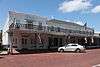
| 4 |
Excelsior Hotel |
|
000000001969-10-28-0000October 28, 1969
(#69000208) |
Austin St., between Market and Vale Sts.
32°45′21″N 94°20′44″W / 32.755833°N 94.345556°W / 32.755833; -94.345556 (Excelsior Hotel) |
Jefferson |
|
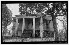
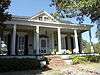
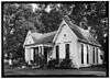
| 5 |
Freeman Plantation House |
|
000000001969-11-25-0000November 25, 1969
(#69000209) |
0.8 mi (1.3 km). west of Jefferson on TX 49
32°45′48″N 94°22′12″W / 32.763333°N 94.37°W / 32.763333; -94.37 (Freeman Plantation House) |
Jefferson |
|
| 6 |
Hodge-Taylor House |
|
000000001997-03-21-0000March 21, 1997
(#97000259) |
Approximately 1 mi (1.6 km) southwest of junction of US 59 and TX 49, W.
32°45′54″N 94°22′20″W / 32.765°N 94.372222°W / 32.765; -94.372222 (Hodge-Taylor House) |
Jefferson |
|
| 7 |
Jefferson Historic District |
|
000000001971-03-31-0000March 31, 1971
(#71000949) |
Roughly bounded by Owens, Dixon, Walnut, Camp, and Taylor Sts.
32°45′21″N 94°20′46″W / 32.755833°N 94.346111°W / 32.755833; -94.346111 (Jefferson Historic District) |
Jefferson |
|
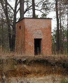
| 8 |
Jefferson Ordnance Magazine |
|
000000001995-02-17-0000February 17, 1995
(#95000102) |
0.3 mi (0.48 km) northeast of US 59B crossing of Big Cypress Bayou
32°45′29″N 94°20′18″W / 32.758056°N 94.338333°W / 32.758056; -94.338333 (Jefferson Ordnance Magazine) |
Jefferson |
|
| 9 |
Jefferson Playhouse |
|
000000001969-10-28-0000October 28, 1969
(#69000374) |
Northwest corner of Market and Henderson Sts.
32°45′25″N 94°20′51″W / 32.756944°N 94.3475°W / 32.756944; -94.3475 (Jefferson Playhouse) |
Jefferson |
|
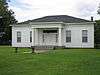
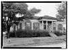
| 10 |
The Magnolias |
|
000000001971-03-31-0000March 31, 1971
(#71000951) |
209 E. Broadway
32°45′42″N 94°21′10″W / 32.761667°N 94.352778°W / 32.761667; -94.352778 (The Magnolias) |
Jefferson |
|
| 11 |
Old U.S. Post Office and Courts Building |
|
000000001969-10-28-0000October 28, 1969
(#69000210) |
223 W. Austin St.
32°45′20″N 94°20′45″W / 32.755556°N 94.345833°W / 32.755556; -94.345833 (Old U.S. Post Office and Courts Building) |
Jefferson |
|
| 12 |
Capt. William Perry House |
|
000000001970-08-25-0000August 25, 1970
(#70000755) |
Northwest corner of Walnut and Clarksville Sts.
32°45′38″N 94°20′49″W / 32.760556°N 94.346944°W / 32.760556; -94.346944 (Capt. William Perry House) |
Jefferson |
|
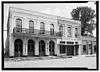
| 13 |
Planters Bank Building |
|
000000001971-03-11-0000March 11, 1971
(#71000952) |
224 E. Austin St.
32°45′26″N 94°20′42″W / 32.757222°N 94.345°W / 32.757222; -94.345 (Planters Bank Building) |
Jefferson |
|
| 14 |
Presbyterian Manse |
|
000000001969-10-28-0000October 28, 1969
(#69000211) |
Northeast corner of Alley and Delta Sts.
32°45′27″N 94°21′03″W / 32.7575°N 94.350833°W / 32.7575; -94.350833 (Presbyterian Manse) |
Jefferson |
|
| 15 |
Sedberry House |
|
000000001970-08-25-0000August 25, 1970
(#70000756) |
211 N. Market St.
32°45′24″N 94°20′51″W / 32.756667°N 94.3475°W / 32.756667; -94.3475 (Sedberry House) |
Jefferson |
|
| 16 |
Capt. William E. Singleton House |
|
000000001970-08-25-0000August 25, 1970
(#70000757) |
204 N. Soda St.
32°45′37″N 94°21′21″W / 32.760278°N 94.355833°W / 32.760278; -94.355833 (Capt. William E. Singleton House) |
Jefferson |
|
| 17 |
Stilley-Young House |
|
000000002005-09-28-0000September 28, 2005
(#05001105) |
405 Moseley St.
32°45′22″N 94°21′05″W / 32.756111°N 94.351389°W / 32.756111; -94.351389 (Stilley-Young House) |
Jefferson |
|
| 18 |
Perry M. Woods House |
|
000000001971-03-31-0000March 31, 1971
(#71000953) |
502 Walker St.
32°45′33″N 94°21′00″W / 32.759167°N 94.35°W / 32.759167; -94.35 (Perry M. Woods House) |
Jefferson |
|
See also
References
- ↑ The latitude and longitude information provided in this table was derived originally from the National Register Information System, which has been found to be fairly accurate for about 99% of listings. For about 1% of NRIS original coordinates, experience has shown that one or both coordinates are typos or otherwise extremely far off; some corrections may have been made. A more subtle problem causes many locations to be off by up to 150 yards, depending on location in the country: most NRIS coordinates were derived from tracing out latitude and longitudes off of USGS topographical quadrant maps created under the North American Datum of 1927, which differs from the current, highly accurate WGS84 GPS system used by most on-line maps. Chicago is about right, but NRIS longitudes in Washington are higher by about 4.5 seconds, and are lower by about 2.0 seconds in Maine. Latitudes differ by about 1.0 second in Florida. Some locations in this table may have been corrected to current GPS standards.
- ↑ "National Register of Historic Places: Weekly List Actions". National Park Service, United States Department of the Interior. Retrieved on December 2, 2016.
- ↑ Numbers represent an ordering by significant words. Various colorings, defined here, differentiate National Historic Landmarks and historic districts from other NRHP buildings, structures, sites or objects.
- ↑ National Park Service (2008-04-24). "National Register Information System". National Register of Historic Places. National Park Service.
- ↑ The eight-digit number below each date is the number assigned to each location in the National Register Information System database, which can be viewed by clicking the number.
|
|---|
|
| Topics | |
|---|
|
| Lists by states | |
|---|
|
| Lists by insular areas | |
|---|
|
| Lists by associated states | |
|---|
|
| Other areas | |
|---|
|
-
 Portal Portal
-
 WikiProject WikiProject
|