National Register of Historic Places listings in McLennan County, Texas
List of Registered Historic Places in McLennan County, Texas
This is intended to be a complete list of properties and districts listed on the National Register of Historic Places in McLennan County, Texas. The locations of National Register properties and districts (at least for all showing latitude and longitude coordinates below) may be seen in a map by clicking on "Map of all coordinates".[1]
- This National Park Service list is complete through NPS recent listings posted December 2, 2016.[2]
Current listings
| [3] | Name on the Register[4] | Image | Date listed[5] | Location | City or town | Description |
|---|---|---|---|---|---|---|
| 1 | Artesian Manufacturing and Bottling Company Building | 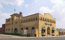 |
(#83003152) |
300 S. 5th St. 31°33′18″N 97°07′47″W / 31.555°N 97.129722°W |
Waco | Currently houses the Dr Pepper Museum |
| 2 | Castle Heights Historic District |  |
(#07000495) |
Roughly bounded by Waco Dr. (U.S. Route 84), Oriental Rd., Franklin Ave., and 39th St. 31°31′58″N 97°09′40″W / 31.532836°N 97.161147°W |
Waco | |
| 3 | Madison Cooper House | 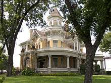 |
(#82004514) |
1801 Austin Ave. 31°32′46″N 97°08′39″W / 31.546111°N 97.144167°W |
Waco | |
| 4 | Earle-Napier-Kinnard House | 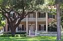 |
(#71001017) |
814 S. 4th St. 31°34′43″N 97°07′21″W / 31.578611°N 97.1225°W |
Waco | |
| 5 | Forsgard Homestead |  |
(#03001161) |
1116-1122 N. 4th St. 31°33′51″N 97°08′24″W / 31.564167°N 97.14°W |
Waco | |
| 6 | Fort House |  |
(#70000849) |
503 E. 4th St. 31°33′14″N 97°07′35″W / 31.553889°N 97.126389°W |
Waco | |
| 7 | Hippodrome | 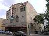 |
(#83003153) |
724 Austin Ave. 31°33′16″N 97°08′03″W / 31.554583°N 97.134167°W |
Waco | |
| 8 | John Wesley Mann House | 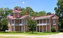 |
(#72001466) |
100 Mill St. 31°34′02″N 97°08′01″W / 31.567222°N 97.133611°W |
Waco | |
| 9 | McClennan County Courthouse | 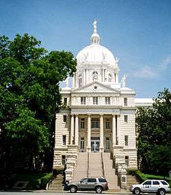 |
(#78003095) |
Public Sq. 31°33′26″N 97°08′01″W / 31.557222°N 97.133611°W |
Waco | |
| 10 | McCulloch House |  |
(#72001467) |
406 Columbus Ave. 31°33′32″N 97°07′58″W / 31.558889°N 97.132778°W |
Waco | |
| 11 | McDermott Motors Building | 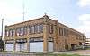 |
(#03001415) |
1125 Washington Ave. 31°33′08″N 97°08′22″W / 31.552222°N 97.139444°W |
Waco | |
| 12 | Praetorian Building | 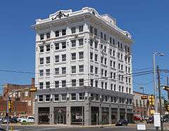 |
(#84001911) |
601 Franklin Ave. 31°33′18″N 97°07′55″W / 31.555°N 97.131944°W |
Waco | |
| 13 | Rotan-Dossett House |  |
(#79003151) |
1503 Columbus Ave. 31°33′01″N 97°08′35″W / 31.550278°N 97.143056°W |
Waco | |
| 14 | Texas Textile Mills-L.L. Sams Company Historic District |  |
(#03000807) |
2100 River St. 31°32′42″N 97°06′31″W / 31.545°N 97.108611°W |
Waco | |
| 15 | Torrey's Trading House No. 2 Site | Upload image | (#75002074) |
Address Restricted |
Waco | |
| 16 | Veterans Administration Hospital Historic District |  |
(#94000672) |
4800 Memorial Dr. 31°30′40″N 97°09′54″W / 31.511111°N 97.165°W |
Waco | |
| 17 | Waco Downtown Historic District | 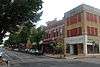 |
(#11001094) |
Roughly bounded by Mary Ave., S. 14th St., Columbus Ave., and S. University Parks Dr. 31°33′18″N 97°08′02″W / 31.554972°N 97.133919°W |
Waco | |
| 18 | Waco Drug Company | 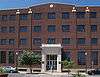 |
(#08000241) |
225 S. 5th St. 31°33′19″N 97°07′50″W / 31.555278°N 97.130556°W |
Waco | |
| 19 | Waco High School |  |
(#09000140) |
815 Columbus 31°33′22″N 97°08′15″W / 31.556111°N 97.1375°W |
Waco | |
| 20 | Waco Suspension Bridge | |
(#70000850) |
At Bridge St., over the Brazos River 31°33′40″N 97°07′39″W / 31.561111°N 97.1275°W |
Waco | |
| 21 | Washington Avenue Bridge | 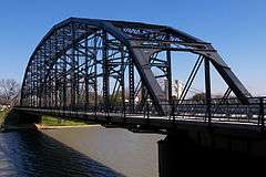 |
(#98000143) |
Washington and Elm Aves. across the Brazos River 31°33′40″N 97°07′43″W / 31.561111°N 97.128611°W |
Waco |
Former listing
| [3] | Name on the Register | Image | Date listed | Date removed | Location | City or town | Summary |
|---|---|---|---|---|---|---|---|
| 1 | Brown-Mann House |  |
(#87001887) | 725 W. Sixth St. 31°26′06″N 97°24′30″W / 31.435°N 97.408333°W |
McGregor | Destroyed by fire 02/24/14 |
See also
| Wikimedia Commons has media related to National Register of Historic Places in McLennan County, Texas. |
References
- ↑ The latitude and longitude information provided in this table was derived originally from the National Register Information System, which has been found to be fairly accurate for about 99% of listings. For about 1% of NRIS original coordinates, experience has shown that one or both coordinates are typos or otherwise extremely far off; some corrections may have been made. A more subtle problem causes many locations to be off by up to 150 yards, depending on location in the country: most NRIS coordinates were derived from tracing out latitude and longitudes off of USGS topographical quadrant maps created under the North American Datum of 1927, which differs from the current, highly accurate WGS84 GPS system used by most on-line maps. Chicago is about right, but NRIS longitudes in Washington are higher by about 4.5 seconds, and are lower by about 2.0 seconds in Maine. Latitudes differ by about 1.0 second in Florida. Some locations in this table may have been corrected to current GPS standards.
- ↑ "National Register of Historic Places: Weekly List Actions". National Park Service, United States Department of the Interior. Retrieved on December 2, 2016.
- 1 2 Numbers represent an ordering by significant words. Various colorings, defined here, differentiate National Historic Landmarks and historic districts from other NRHP buildings, structures, sites or objects.
- ↑ National Park Service (2008-04-24). "National Register Information System". National Register of Historic Places. National Park Service.
- ↑ The eight-digit number below each date is the number assigned to each location in the National Register Information System database, which can be viewed by clicking the number.
 |
Bosque County | Hill County | | |
| |
Limestone County | |||
| ||||
| | ||||
| Coryell County | Bell County | Falls County |
| Topics | |
|---|---|
| Lists by states |
|
| Lists by insular areas | |
| Lists by associated states | |
| Other areas | |
| |
This article is issued from Wikipedia - version of the 7/3/2016. The text is available under the Creative Commons Attribution/Share Alike but additional terms may apply for the media files.