National Register of Historic Places listings in Nacogdoches County, Texas
List of Registered Historic Places in Nacogdoches County, Texas
This is intended to be a complete list of properties and districts listed on the National Register of Historic Places in Nacogdoches County, Texas. The locations of National Register properties and districts (at least for all showing latitude and longitude coordinates below) may be seen in a map by clicking on "Map of all coordinates".[1]
- This National Park Service list is complete through NPS recent listings posted December 2, 2016.[2]
| [3] | Name on the Register[4] | Image | Date listed[5] | Location | City or town | Description |
|---|---|---|---|---|---|---|
| 1 | Tol Barret House | 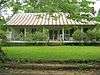 |
(#79002998) |
S of Nacogdoches 31°32′09″N 94°40′01″W / 31.535833°N 94.666944°W |
Nacogdoches | |
| 2 | Eugene H. Blount House | 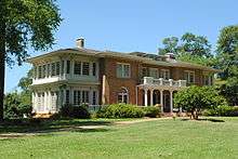 |
(#92000014) |
1801 North St. 31°37′07″N 94°39′11″W / 31.618611°N 94.653056°W |
Nacogdoches | |
| 3 | Stephen William and Mary Price Blount House | .jpg) |
(#90002180) |
310 N. Mound St. 31°36′19″N 94°39′02″W / 31.605278°N 94.650556°W |
Nacogdoches | |
| 4 | Maria A. Davidson Apartments | .jpg) |
(#92000009) |
214 S. Fredonia St. 31°36′06″N 94°39′18″W / 31.601667°N 94.655°W |
Nacogdoches | |
| 5 | Bernardo D'Ortolan Rancho Site | Upload image | (#14000101) |
Address Restricted |
Nacogdoches | |
| 6 | Raphael D'Ortolan Site | Upload image | (#14000100) |
Address Restricted |
Nacogdoches | |
| 7 | Durst-Taylor House |  |
(#03000808) |
304 North St. 31°36′19″N 94°39′16″W / 31.605278°N 94.654444°W |
Nacogdoches | |
| 8 | Hayter Office Building | .jpg) |
(#92000010) |
112 E. Main St. 31°36′11″N 94°39′19″W / 31.603056°N 94.655278°W |
Nacogdoches | |
| 9 | Hoya Land Office Building | 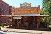 |
(#92000015) |
120 E. Pilar St. 31°36′08″N 94°39′21″W / 31.602222°N 94.655833°W |
Nacogdoches | |
| 10 | Roland Jones House | 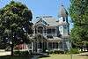 |
(#92000007) |
141 N. Church St. 31°36′13″N 94°39′10″W / 31.603611°N 94.652778°W |
Nacogdoches | |
| 11 | Nacogdoches Downtown Historic District | 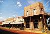 |
(#08000478) |
Roughly bounded by Southern Pacific RR tracks, Banita Cr., Pilar, Mound, Arnold, North & Hospital Sts., 31°36′18″N 94°39′20″W / 31.605°N 94.655556°W |
Nacogdoches | |
| 12 | Oil Springs Oil Field Discovery Well | Upload image | (#77001461) |
4 mi (6.4 km). SE of Woden 31°28′20″N 94°28′03″W / 31.472222°N 94.4675°W |
Woden | |
| 13 | Old Cotton Exchange Building | 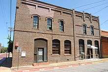 |
(#92000008) |
305 E. Commerce St. 31°36′12″N 94°39′13″W / 31.603333°N 94.653611°W |
Nacogdoches | |
| 14 | Old Nacogdoches University Building | 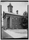 |
(#71000956) |
Washington Sq. 31°36′24″N 94°39′05″W / 31.606667°N 94.651389°W |
Nacogdoches | |
| 15 | Old Post Office Building | 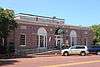 |
(#92000011) |
206 E. Main St. 31°36′10″N 94°39′18″W / 31.602778°N 94.655°W |
Nacogdoches | |
| 16 | Roberts Building | .jpg) |
(#92000016) |
216 E. Pilar St. 31°36′07″N 94°39′17″W / 31.601944°N 94.654722°W |
Nacogdoches | |
| 17 | Southern Pacific Railroad Depot |  |
(#92000013) |
500 W. Main St. 31°36′18″N 94°39′32″W / 31.605°N 94.658889°W |
Nacogdoches | |
| 18 | Adolphus Sterne House | 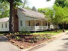 |
(#76002053) |
211 S. Lanana St. 31°36′00″N 94°39′02″W / 31.6°N 94.650556°W |
Nacogdoches | |
| 19 | Sterne-Hoya Historic District | .jpg) |
(#92000017) |
100-200 blocks of S. Lanana St., 500 block of E. Main St. (S side), 500 block of E. Pilar St. 31°36′02″N 94°39′04″W / 31.600556°N 94.651111°W |
Nacogdoches | |
| 20 | Virginia Avenue Historic District | 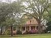 |
(#92000018) |
500 block of Bremond (W side), 500-1800 blocks of Virginia Ave., 521 Weaver 31°35′58″N 94°39′38″W / 31.599444°N 94.660556°W |
Nacogdoches | |
| 21 | Washington Square Historic District | .jpg) |
(#92000019) |
Roughly bounded by Houston, Logansport, N. Lanana, E. Hospital and N. Fredonia Sts. 31°36′26″N 94°38′59″W / 31.607222°N 94.649722°W |
Nacogdoches | |
| 22 | Woodmen of the World Building | 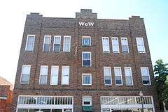 |
(#92000012) |
412 E. Main St. 31°36′08″N 94°39′13″W / 31.602222°N 94.653611°W |
Nacogdoches | |
| 23 | Zion Hill Historic District | .jpg) |
(#92001759) |
Roughly bounded by Park St., Lanana Cr., Oak Grove Cemetery and N. Lanana St. 31°36′20″N 94°38′50″W / 31.605556°N 94.647222°W |
Nacogdoches |
See also
| Wikimedia Commons has media related to National Register of Historic Places in Nacogdoches County, Texas. |
References
- ↑ The latitude and longitude information provided in this table was derived originally from the National Register Information System, which has been found to be fairly accurate for about 99% of listings. For about 1% of NRIS original coordinates, experience has shown that one or both coordinates are typos or otherwise extremely far off; some corrections may have been made. A more subtle problem causes many locations to be off by up to 150 yards, depending on location in the country: most NRIS coordinates were derived from tracing out latitude and longitudes off of USGS topographical quadrant maps created under the North American Datum of 1927, which differs from the current, highly accurate WGS84 GPS system used by most on-line maps. Chicago is about right, but NRIS longitudes in Washington are higher by about 4.5 seconds, and are lower by about 2.0 seconds in Maine. Latitudes differ by about 1.0 second in Florida. Some locations in this table may have been corrected to current GPS standards.
- ↑ "National Register of Historic Places: Weekly List Actions". National Park Service, United States Department of the Interior. Retrieved on December 2, 2016.
- ↑ Numbers represent an ordering by significant words. Various colorings, defined here, differentiate National Historic Landmarks and historic districts from other NRHP buildings, structures, sites or objects.
- ↑ National Park Service (2008-04-24). "National Register Information System". National Register of Historic Places. National Park Service.
- ↑ The eight-digit number below each date is the number assigned to each location in the National Register Information System database, which can be viewed by clicking the number.
| Topics | |
|---|---|
| Lists by states |
|
| Lists by insular areas | |
| Lists by associated states | |
| Other areas | |
| |
This article is issued from Wikipedia - version of the 9/13/2016. The text is available under the Creative Commons Attribution/Share Alike but additional terms may apply for the media files.