National Register of Historic Places listings in Potter County, Texas
List of Registered Historic Places in Potter County, Texas
This is intended to be a complete list of properties and districts listed on the National Register of Historic Places in Potter County, Texas. The locations of National Register properties and districts (at least for all showing latitude and longitude coordinates below) may be seen in a map by clicking on "Map of all coordinates".[1]
- This National Park Service list is complete through NPS recent listings posted December 2, 2016.[2]
| [3] | Name on the Register | Image | Date listed[4] | Location | City or town | Description |
|---|---|---|---|---|---|---|
| 1 | Alibates Flint Quarries National Monument | 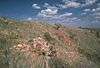 |
(#66000822) |
SW of Fritch on the Canadian River 35°34′56″N 101°40′19″W / 35.582092°N 101.672078°W |
Fritch | |
| 2 | Amarillo College Administration Building and Gymnasium | 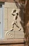 |
(#91002023) |
2201 S. Washington St. and 2221 S. Washington St. 35°11′18″N 101°50′53″W / 35.188335°N 101.848164°W |
Amarillo | |
| 3 | Amarillo US Post Office and Courthouse | 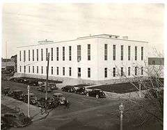 |
(#00001175) |
205 E. Fifth St. 35°12′31″N 101°50′03″W / 35.208611°N 101.834167°W |
Amarillo | |
| 4 | Atchison, Topeka and Santa Fe Railway Company Depot and Locomotive No. 5000 |  |
(#86002189) |
Corner of 2nd and Lincoln 35°12′31″N 101°49′36″W / 35.208611°N 101.826667°W |
Amarillo | Moved from original location at 307 S Grant in 2005[5] |
| 5 | Bivins House |  |
(#74002088) |
1000 Polk St. 35°12′11″N 101°50′17″W / 35.203056°N 101.838056°W |
Amarillo | |
| 6 | Miles and Myda Bivins House |  |
(#92001306) |
2311 W. 16th Ave. 35°11′49″N 101°51′47″W / 35.196944°N 101.863056°W |
Amarillo | |
| 7 | Central Presbyterian Church |  |
(#91001649) |
1100 Harrison St. 35°12′10″N 101°50′26″W / 35.202778°N 101.840556°W |
Amarillo | |
| 8 | Alice Ghormley Curtis House | 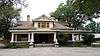 |
(#92000980) |
1626 S. Washington St. 35°11′48″N 101°50′54″W / 35.196667°N 101.848333°W |
Amarillo | |
| 9 | Douglas DC-3 Airplane, N34 | 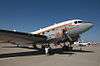 |
(#97000443) |
Texas Air & Space Museum, 10001 American Drive 35°12′48″N 101°42′53″W / 35.2133°N 101.7148°W |
Amarillo | relocated from Oklahoma City in 2014[6] |
| 10 | First Baptist Church |  |
(#83003158) |
218 W. 13th St. 35°12′04″N 101°50′22″W / 35.201111°N 101.839444°W |
Amarillo | |
| 11 | Fisk Medical Arts Building |  |
(#12001003) |
724 S. Polk St. 35°12′21″N 101°50′16″W / 35.20584°N 101.83774°W |
Amarillo | Now a Courtyard by Marriott hotel |
| 12 | Jons-Gilvin House |  |
(#92000983) |
1500 S. Buchanan St. 35°11′51″N 101°50′01″W / 35.1975°N 101.833611°W |
Amarillo | |
| 13 | Kouns-Jackson House | 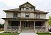 |
(#92000981) |
1118 S. Harrison St. 35°12′07″N 101°50′26″W / 35.201944°N 101.840556°W |
Amarillo | |
| 14 | Landergin-Harrington House | 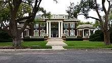 |
(#77001466) |
1600 Polk St. 35°11′49″N 101°50′20″W / 35.196944°N 101.838889°W |
Amarillo | |
| 15 | McBride Canyon Ruin | Upload image | (#85001483) |
Address Restricted |
Fritch | |
| 16 | McBride Ranch House | 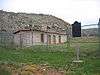 |
(#75000152) |
North of Amarillo in Lake Meredith National Recreation Area 35°32′29″N 101°43′44″W / 35.541389°N 101.728889°W |
Amarillo | |
| 17 | McMillen Apartments | _Apartments_1320_S._Fillmore_Amarillo_20140916.jpg) |
(#10000145) |
1320 S. Fillmore 35°11′58″N 101°50′11″W / 35.199444°N 101.836389°W |
Amarillo | |
| 18 | Northwest Texas Hospital School of Nursing |  |
(#96001234) |
2209 W. 6th Ave. 35°12′32″N 101°55′39″W / 35.208889°N 101.9275°W |
Amarillo | |
| 19 | Plemons-Mrs. M. D. Oliver-Eakle Additions Historic District | Upload image | (#92000370) |
Roughly bounded by 16th Ave., Taylor St., 26th Ave., Van Buren St., I-40 and Madison St. 35°11′29″N 101°50′33″W / 35.191389°N 101.8425°W |
Amarillo | |
| 20 | Polk Street Methodist Church | 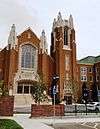 |
(#91002021) |
1401 S. Polk St. 35°11′56″N 101°50′17″W / 35.198889°N 101.838056°W |
Amarillo | |
| 21 | Potter County Courthouse and Library |  |
(#96000938) |
501 S. Taylor St. 35°12′29″N 101°50′06″W / 35.208056°N 101.835°W |
Amarillo | |
| 22 | Ranchotel | |
(#95000411) |
2501 W. Sixth Ave. 35°12′40″N 101°51′54″W / 35.211154°N 101.865125°W |
Amarillo | |
| 23 | Henry B. and Ellen M. Sanborn House | 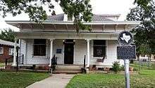 |
(#92000982) |
1311 S. Madison St. 35°11′59″N 101°50′25″W / 35.199722°N 101.840278°W |
Amarillo | |
| 24 | Santa Fe Building | 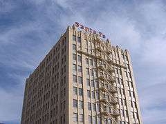 |
(#96000939) |
900 S. Polk St. 35°12′16″N 101°50′15″W / 35.204444°N 101.8375°W |
Amarillo | |
| 25 | Shelton-Houghton House | 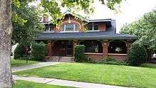 |
(#80004145) |
1700 Polk St. 35°11′42″N 101°50′22″W / 35.195°N 101.839444°W |
Amarillo | |
| 26 | Louis H. Smith Inc. Firestone Store | _E_side_N_end_1.JPG) |
(#15000451) |
1004 South Tyler Street 35°12′12″N 101°50′22″W / 35.203464°N 101.839572°W |
Amarillo | |
| 27 | Triangle Motel | 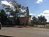 |
(#10000982) |
7804, 7808, 7954, and 8024 E. Amarillo Blvd. 35°13′20″N 101°44′52″W / 35.222222°N 101.747778°W |
Amarillo | Route 66 in Texas MPS |
| 28 | US Route 66-Sixth Street Historic District | 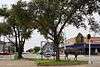 |
(#94000982) |
Sixth Ave. between Georgia and Forrest Aves. 35°12′40″N 101°52′24″W / 35.211111°N 101.873333°W |
Amarillo | |
| 29 | Vineyard Manor | _from_NW_1.JPG) |
(#14000965) |
1201 S. Polk Street 35°12′04″N 101°50′17″W / 35.201222°N 101.838074°W |
Amarillo | |
| 30 | Wolflin Historic District | Upload image | (#92000581) |
Roughly bounded by Wolflin Ave., Washington St., SW. 34th Ave., Parker St., SW. 30th Ave. and Lipscomb St. 35°11′07″N 101°51′07″W / 35.185278°N 101.851944°W |
Amarillo |
See also
| Wikimedia Commons has media related to National Register of Historic Places in Potter County, Texas. |
References
- ↑ The latitude and longitude information provided in this table was derived originally from the National Register Information System, which has been found to be fairly accurate for about 99% of listings. For about 1% of NRIS original coordinates, experience has shown that one or both coordinates are typos or otherwise extremely far off; some corrections may have been made. A more subtle problem causes many locations to be off by up to 150 yards, depending on location in the country: most NRIS coordinates were derived from tracing out latitude and longitudes off of USGS topographical quadrant maps created under the North American Datum of 1927, which differs from the current, highly accurate WGS84 GPS system used by most on-line maps. Chicago is about right, but NRIS longitudes in Washington are higher by about 4.5 seconds, and are lower by about 2.0 seconds in Maine. Latitudes differ by about 1.0 second in Florida. Some locations in this table may have been corrected to current GPS standards.
- ↑ "National Register of Historic Places: Weekly List Actions". National Park Service, United States Department of the Interior. Retrieved on December 2, 2016.
- ↑ Numbers represent an ordering by significant words. Various colorings, defined here, differentiate National Historic Landmarks and historic districts from other NRHP buildings, structures, sites or objects.
- ↑ The eight-digit number below each date is the number assigned to each location in the National Register Information System database, which can be viewed by clicking the number.
- ↑ Santa Fe Preserved Locomotives
- ↑ Texas Air and Space Museum
| Topics | |
|---|---|
| Lists by states |
|
| Lists by insular areas | |
| Lists by associated states | |
| Other areas | |
| |
This article is issued from Wikipedia - version of the 7/3/2016. The text is available under the Creative Commons Attribution/Share Alike but additional terms may apply for the media files.