National Register of Historic Places listings in Rock County, Wisconsin
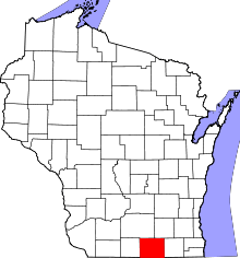
Location of Rock County in Wisconsin
This is a list of the National Register of Historic Places listings in Rock County, Wisconsin. It is intended to provide a comprehensive listing of entries in the National Register of Historic Places that are located in Rock County, Wisconsin. The locations of National Register properties for which the latitude and longitude coordinates are included below may be seen in a map.[1]
There are 138 properties and districts listed on the National Register in the county. Another seven properties were once listed but have been removed.
- This National Park Service list is complete through NPS recent listings posted December 2, 2016.[2]
Current listings
| [3] | Name on the Register[4] | Image | Date listed[5] | Location | City or town | Description |
|---|---|---|---|---|---|---|
| 1 | John Alexander Wheat Warehouse |  |
(#78003383) |
304 S. Janesville St. 42°46′29″N 88°56′11″W / 42.774722°N 88.936389°W |
Milton | |
| 2 | Abram Allen House |  |
(#78003386) |
205 E. Madison Ave. 42°46′45″N 88°56′54″W / 42.779167°N 88.948333°W |
Milton | |
| 3 | The Armory |  |
(#78000130) |
10 S. High St. 42°40′49″N 89°01′40″W / 42.680278°N 89.027778°W |
Janesville | |
| 4 | Bartlett Memorial Historical Museum |  |
(#77000048) |
2149 St. Lawrence Ave. 42°30′15″N 89°04′10″W / 42.504167°N 89.069444°W |
Beloit | |
| 5 | Beloit Water Tower |  |
(#83003410) |
1005 Pleasant St. 42°30′33″N 89°01′49″W / 42.509167°N 89.030278°W |
Beloit | |
| 6 | Benton Avenue Historic District |  |
(#96000251) |
Roughly bounded by Benton Ave., Milton Ave., Sherman Ave., Richardson St., Blaine Ave. and Prairie Ave. 42°41′48″N 89°00′48″W / 42.696667°N 89.013333°W |
Janesville | |
| 7 | Selvy Blodgett House |  |
(#80000183) |
417 Bluff St. 42°29′59″N 89°02′29″W / 42.499722°N 89.041389°W |
Beloit | |
| 8 | Bluff Street Historic District |  |
(#83003411) |
Roughly both sides of Bluff St. from Shirland Ave. to Merrill St. 42°30′04″N 89°02′30″W / 42.501111°N 89.041667°W |
Beloit | |
| 9 | Bostwick Avenue Historic District |  |
(#06000321) |
404-436 Bostwick Ave. and 1118 and 1128 Grace St. 42°40′56″N 89°00′37″W / 42.682222°N 89.010278°W |
Janesville | |
| 10 | Brasstown Cottage |  |
(#83003412) |
1701 Colley Rd. 42°30′26″N 89°00′53″W / 42.507222°N 89.014722°W |
Beloit | |
| 11 | Church of St. Thomas the Apostle |  |
(#83003413) |
822 E. Grand Ave. 42°29′58″N 89°01′41″W / 42.499444°N 89.028056°W |
Beloit | |
| 12 | Citizens Bank |  |
(#85001661) |
Front & Allen Sts. 42°33′12″N 88°51′46″W / 42.553333°N 88.862778°W |
Clinton | |
| 13 | City of Beloit Waterworks and Pump Station | 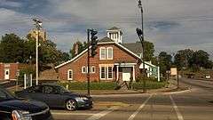 |
(#90001460) |
1005 Pleasant St. 42°30′32″N 89°01′51″W / 42.508889°N 89.030833°W |
Beloit | |
| 14 | Clark-Brown House | 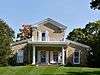 |
(#85002126) |
3457 Riverside Dr. 42°33′45″N 89°02′06″W / 42.5625°N 89.035°W |
Beloit | |
| 15 | Clinton Village Hall | 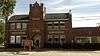 |
(#85001660) |
301 Cross St. 42°33′18″N 88°51′42″W / 42.555°N 88.861667°W |
Clinton | |
| 16 | Clinton Water Tower | 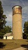 |
(#85000493) |
High St. 42°33′39″N 88°51′48″W / 42.560833°N 88.863333°W |
Clinton | |
| 17 | Columbus Circle Historic District |  |
(#05000453) |
Columbus Circle generally bounded by N. Adams and E. Milwaukee Sts. and N. Garfield Ave. 42°41′24″N 89°00′38″W / 42.69°N 89.010556°W |
Janesville | |
| 18 | Conrad Cottages Historic District |  |
(#93000157) |
235-330 Milton Ave. 42°41′12″N 89°01′03″W / 42.686667°N 89.0175°W |
Janesville | |
| 19 | Cooksville Cheese Factory |  |
(#80000395) |
SR 1 42°50′06″N 89°14′36″W / 42.835°N 89.243333°W |
Evansville | |
| 20 | Cooksville Historic District |  |
(#73000254) |
Both sides of streets bordering the Public Sq. and Rock St. 42°50′08″N 89°14′19″W / 42.835556°N 89.238611°W |
Cooksville | Boundary increase (listed September 17, 1980): Roughly Tolles Rd., Church St., Rock St., Dane St., and Main St. |
| 21 | Cooksville Mill and Mill Pond Site |  |
(#80000394) |
SR 1 42°50′19″N 89°14′32″W / 42.838611°N 89.242222°W |
Evansville | |
| 22 | Cooper-Gillies House |  |
(#80000397) |
SR 1 42°50′03″N 89°15′17″W / 42.834167°N 89.254722°W |
Evansville | |
| 23 | Courier Building |  |
(#15000552) |
513 Vernal Ave. 42°46′50″N 88°57′47″W / 42.780609°N 88.963117°W |
Milton | |
| 24 | Court Street Methodist Church |  |
(#77000045) |
36 S. Main St. 42°40′55″N 89°01′17″W / 42.681944°N 89.021389°W |
Janesville | |
| 25 | Courthouse Hill Historic District |  |
(#86000205) |
Roughly bounded by E. Milwaukee St., Garfield and Oakland Aves., S. Main St., and E. Court St. and Milton Ave. 42°41′00″N 89°00′58″W / 42.683333°N 89.016111°W |
Janesville | |
| 26 | J. W. Crist House |  |
(#83003414) |
2601 Afton Rd. 42°32′26″N 89°03′04″W / 42.540556°N 89.051111°W |
Beloit | |
| 27 | Crosby Block |  |
(#85001658) |
102 Allen St. 42°33′12″N 88°51′46″W / 42.553333°N 88.862778°W |
Clinton | |
| 28 | James B. Crosby House |  |
(#95001454) |
1005 Sutherland Ave. 42°41′41″N 89°01′27″W / 42.694722°N 89.024167°W |
Janesville | |
| 29 | Charles L. Culton House |  |
(#77000046) |
708 Washington St. 42°50′19″N 89°04′34″W / 42.838611°N 89.076111°W |
Edgerton | |
| 30 | De Jean House |  |
(#78003388) |
27 Third St. 42°46′54″N 88°57′33″W / 42.781667°N 88.959167°W |
Milton | |
| 31 | Erastus Dean Farmstead |  |
(#78000131) |
E of Janesville on U.S. 14 42°39′20″N 88°52′50″W / 42.655556°N 88.880556°W |
Janesville | |
| 32 | Homer B. DeLong House |  |
(#85001659) |
500 Milwaukee Rd. 42°33′29″N 88°51′51″W / 42.558056°N 88.864167°W |
Clinton | |
| 33 | John T. Dow House |  |
(#80000396) |
SR 1 42°50′05″N 89°14′49″W / 42.834722°N 89.246944°W |
Evansville | |
| 34 | Eager Free Public Library |  |
(#77000047) |
39 W. Main St. 42°46′48″N 89°18′03″W / 42.780037°N 89.300950°W |
Evansville | |
| 35 | Almeron Eager Funerary Monument and Plot |  |
(#11000477) |
8012 N. Cemetery Rd. 42°46′59″N 89°17′21″W / 42.783056°N 89.289167°W |
Evansville | |
| 36 | East Milwaukee Street Historic District |  |
(#80000184) |
N. Parker Dr. and E. Milwaukee St. 42°41′01″N 89°01′18″W / 42.683611°N 89.021667°W |
Janesville | |
| 37 | Edgerton Depot |  |
(#98000283) |
20 S. Main St. 42°50′00″N 89°04′13″W / 42.833333°N 89.070278°W |
Edgerton | |
| 38 | Edgerton Post Office |  |
(#00001239) |
104 N. Swift St. 42°50′08″N 89°04′16″W / 42.835556°N 89.071111°W |
Edgerton | |
| 39 | Edgerton Public Grade Schools |  |
(#86003568) |
116 N. Swift St. 42°50′09″N 89°04′11″W / 42.835833°N 89.069722°W |
Edgerton | |
| 40 | Emerson Hall | 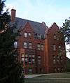 |
(#79000109) |
Beloit College campus 42°30′26″N 89°01′43″W / 42.507222°N 89.028611°W |
Beloit | |
| 41 | Evansville Historic District | 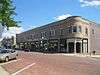 |
(#78000132) |
roughly bounded by Allens Creek, Liberty, 4th and Garfield Sts. 42°46′46″N 89°18′10″W / 42.779444°N 89.302778°W |
Evansville | |
| 42 | Evansville Standpipe | 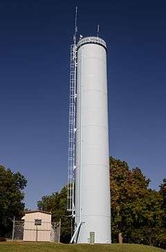 |
(#08000120) |
288 N. 4th St. 42°47′05″N 89°18′47″W / 42.784722°N 89.313056°W |
Evansville | |
| 43 | Fairbanks Flats | 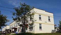 |
(#83003416) |
205, 215 Birch Ave. and 206, 216 Carpenter Ave. 42°31′19″N 89°02′24″W / 42.521944°N 89.04°W |
Beloit | |
| 44 | First Congregational Church | 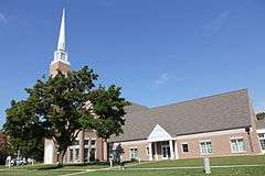 |
(#75000078) |
801 Bushnell St. 42°30′06″N 89°01′40″W / 42.501667°N 89.027778°W |
Beloit | |
| 45 | Footville Condensery | 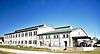 |
(#82000704) |
Beloit St. 42°40′00″N 89°12′27″W / 42.666667°N 89.2075°W |
Footville | |
| 46 | Footville State Bank | 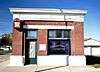 |
(#82000705) |
158 Depot St. 42°40′11″N 89°12′40″W / 42.669722°N 89.211111°W |
Footville | |
| 47 | Fredendall Block | 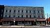 |
(#82000706) |
33-39 S. Main St. 42°40′56″N 89°01′17″W / 42.682222°N 89.021389°W |
Janesville | |
| 48 | Fulton Congregational Church | 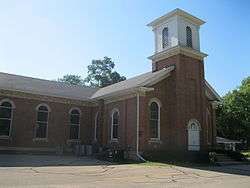 |
(#76000077) |
Fulton St. 42°48′21″N 89°07′44″W / 42.805833°N 89.128889°W |
Fulton | |
| 49 | Fulton Street Historic District | 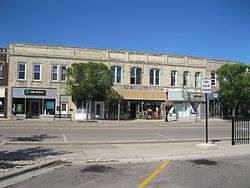 |
(#99000788) |
Along Fulton St., roughly bounded by Main and Albion Sts.; 11-21 Swift St. 42°50′03″N 89°04′13″W / 42.834167°N 89.070278°W |
Edgerton | |
| 50 | Gempeler Round Barn | Upload image | (#79000110) |
SW of Orfordville 42°39′50″N 89°19′50″W / 42.663889°N 89.330556°W |
Orfordville | |
| 51 | Gifford House | 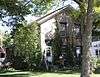 |
(#78003387) |
308 Vernal 42°46′51″N 88°57′36″W / 42.780833°N 88.96°W |
Milton | |
| 52 | Gilley-Tofsland Octagonal Barn | 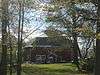 |
(#79000111) |
NW of Edgerton 42°50′40″N 89°10′30″W / 42.844444°N 89.175°W |
Edgerton | |
| 53 | Goodrich Blacksmith Shop |  |
(#78003382) |
28 S. Janesville St. 42°46′34″N 88°56′10″W / 42.776111°N 88.936111°W |
Milton | |
| 54 | Goodrich-Buten House |  |
(#78003385) |
528 E. Madison St. 42°46′38″N 88°56′22″W / 42.777222°N 88.939444°W |
Milton | |
| 55 | Ezra and Elizabeth Goodrich House |  |
(#15000425) |
742 E. Madison Ave. 42°46′38″N 88°56′17″W / 42.777177°N 88.938046°W |
Milton | |
| 56 | William H. and Edith Gray Farmstead |  |
(#15000377) |
313 E. High St. 42°46′23″N 88°56′46″W / 42.7730°N 88.9460°W |
Milton | |
| 57 | Reynolds and Lois Greenman House |  |
(#16000567) |
12 Merchant Row 42°46′59″N 88°57′44″W / 42.782945°N 88.962345°W |
Milton | |
| 58 | Grove Street Historic District |  |
(#11000531) |
103, 111, 112, 116, 119, 125, 126, 133 & 134 Grove St. 42°47′00″N 89°18′08″W / 42.783464°N 89.302222°W |
Evansville | |
| 59 | Hanchett Block |  |
(#80000185) |
307 State St. 42°29′56″N 89°02′08″W / 42.498889°N 89.035556°W |
Beloit | |
| 60 | Haven-Crandall House |  |
(#16000575) |
220 S. Janesville St. 42°46′29″N 88°56′12″W / 42.774837°N 88.936743°W |
Milton | |
| 61 | Hilton House Hotel |  |
(#03001128) |
434 E. Grand Ave. 42°29′58″N 89°02′02″W / 42.499444°N 89.033889°W |
Beloit | No longer standing |
| 62 | How-Beckman Mill |  |
(#77000049) |
11600 County Highway H 42°30′38″N 89°10′12″W / 42.510434°N 89.170053°W |
Beloit | |
| 63 | John and Martha Hugunin House |  |
(#05000534) |
2739 Beloit Ave. 42°38′23″N 89°00′40″W / 42.639692°N 89.011222°W |
Janesville | |
| 64 | Janesville Cotton Mill |  |
(#80000186) |
220 N. Franklin St. 42°41′02″N 89°01′39″W / 42.683889°N 89.0275°W |
Janesville | |
| 65 | Janesville High School |  |
(#99000760) |
408 S. Main St. 42°40′40″N 89°01′02″W / 42.677778°N 89.017222°W |
Janesville | Also known as Marshall Junior High School |
| 66 | Janesville Public Library | 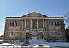 |
(#81000057) |
64 S. Main St. 42°40′53″N 89°01′15″W / 42.681389°N 89.020833°W |
Janesville | |
| 67 | Janesville Pumping Station | 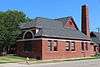 |
(#85000494) |
500 Blk. River St. 42°40′48″N 89°01′22″W / 42.68°N 89.022778°W |
Janesville | |
| 68 | Jefferson Avenue Historic District | 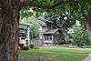 |
(#06000300) |
Bounded by Oakland, Garfield and Ruger Aves. and Forest Park Blvd. 42°41′10″N 89°00′40″W / 42.686111°N 89.011111°W |
Janesville | |
| 69 | John H. Jones House | 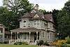 |
(#08000186) |
538 S. Main St. 42°40′36″N 89°00′56″W / 42.676667°N 89.015556°W |
Janesville | |
| 70 | Samuel S. Jones Cobblestone House |  |
(#78000133) |
E of Clinton on Milwaukee Rd. 42°33′57″N 88°49′02″W / 42.565833°N 88.817222°W |
Clinton | |
| 71 | Kinney Farmstead-Tay-e-he-Dah Site |  |
(#78000134) |
1612 E. Hotel Dr. 42°50′32″N 89°00′17″W / 42.842264°N 89.004621°W |
Edgerton | |
| 72 | Lappin-Hayes Block |  |
(#76000224) |
20 E. Milwaukee St. 42°40′58″N 89°01′21″W / 42.682778°N 89.0225°W |
Janesville | |
| 73 | LaPrairie Grange Hall No. 79 |  |
(#77000050) |
SE of Janesville on Town Hall Rd. 42°37′37″N 88°57′12″W / 42.626944°N 88.953333°W |
Janesville | |
| 74 | Lathrop-Munn Cobblestone House |  |
(#77000051) |
524 Bluff St. 42°30′03″N 89°02′31″W / 42.500833°N 89.041944°W |
Beloit | |
| 75 | Leonard—Leota Park |  |
(#12000610) |
20, 30, 40, 50, ca 60, 120, 121 Antes Dr., 321, 340, 359, 360, 363, 365, 395 Burr W. Jones Cir., Leonard Park Dr. 42°47′07″N 89°18′06″W / 42.785362°N 89.30164°W |
Evansville | |
| 76 | Look West Historic District |  |
(#87000506) |
Roughly bounded by Mineral Point Ave., N. Franklin and Race Sts., Laurel Ave., and N. Chatham St. 42°41′03″N 89°02′00″W / 42.684167°N 89.033333°W |
Janesville | Boundary increase (listed December 10, 1993): Roughly bounded by Laurel Ave. and N. Madison, W. Court and N. Palm Sts. |
| 77 | Lovejoy and Merrill-Nowlan Houses |  |
(#80000187) |
220 and 202 St. Lawrence Ave. 42°40′55″N 89°01′07″W / 42.681944°N 89.018611°W |
Janesville | |
| 78 | Masonic Temple |  |
(#15000458) |
508 Vernal Ave. 42°46′51″N 88°57′47″W / 42.780920°N 88.963056°W |
Milton | |
| 79 | Peter McEwan Warehouse |  |
(#78003384) |
711 E. High St. 42°46′22″N 88°56′19″W / 42.772778°N 88.938611°W |
Milton | |
| 80 | Merchant Row Historic District |  |
(#15000504) |
212, 216, 218-220, 228-230 Merchant Row & 553, 537, 541 Vernal Ave. 42°46′54″N 88°57′48″W / 42.781606°N 88.963216°W |
Milton | |
| 81 | Merrill Avenue Historic District |  |
(#93000028) |
103, 107, 111, 115 Merrill Ave. 42°30′34″N 89°02′13″W / 42.509444°N 89.036944°W |
Beloit | |
| 82 | Miller House |  |
(#80000399) |
SR 1 42°49′40″N 89°14′25″W / 42.827778°N 89.240278°W |
Evansville | |
| 83 | Milton College Historic District | 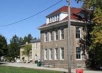 |
(#80000188) |
College St. 42°46′27″N 88°56′32″W / 42.774167°N 88.942222°W |
Milton | |
| 84 | Milton House | 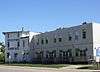 |
(#72000065) |
18 S. Janesville St. 42°46′37″N 88°56′11″W / 42.776944°N 88.936389°W |
Milton | |
| 85 | Moran's Saloon | 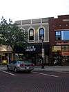 |
(#83003417) |
312 State St. 42°29′57″N 89°02′09″W / 42.499167°N 89.035833°W |
Beloit | |
| 86 | Mouth of the Yahara Archeological District | 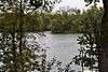 |
(#75000079) |
Address Restricted |
Fulton | |
| 87 | Murray-George House |  |
(#85002125) |
SR P 42°30′33″N 88°56′18″W / 42.509167°N 88.938333°W |
Beloit | |
| 88 | Peter Myers Pork Packing Plant and Willard Coleman Building |  |
(#83003418) |
117-123 N. Main St. 42°41′03″N 89°01′26″W / 42.684167°N 89.023889°W |
Janesville | |
| 89 | Myers-Newhoff House |  |
(#79000277) |
121 N. Parker Dr. 42°41′05″N 89°01′22″W / 42.684722°N 89.022778°W |
Janesville | |
| 90 | Near East Side Historic District |  |
(#83003419) |
Roughly bounded by Pleasant, Clary Sts., Wisconsin and E. Grand Aves. 42°30′10″N 89°01′40″W / 42.502778°N 89.027778°W |
Beloit | |
| 91 | Elbert Neese House |  |
(#83003420) |
1302 Bushnell St 42°30′04″N 89°01′15″W / 42.501111°N 89.020833°W |
Beloit | |
| 92 | North Main Street Historic District |  |
(#80000189) |
N. Main St. and N. Parker Dr. 42°41′02″N 89°01′23″W / 42.683889°N 89.023056°W |
Janesville | |
| 93 | Sterling North House |  |
(#96001579) |
409 W. Rollin St. 42°50′14″N 89°04′04″W / 42.837222°N 89.067778°W |
Edgerton | |
| 94 | Clark Nye House |  |
(#83003422) |
2501 Spring Creek Rd. 42°31′34″N 89°04′45″W / 42.526111°N 89.079167°W |
Beloit | |
| 95 | Old Fourth Ward Historic District |  |
(#90000789) |
Roughly bounded by Washington St., Center Ave., Court St., Franklin St., and Monterey Park 42°40′24″N 89°01′45″W / 42.673333°N 89.029167°W |
Janesville | |
| 96 | Orfordville Depot |  |
(#88002004) |
Beloit St. 42°37′41″N 89°15′22″W / 42.628056°N 89.256111°W |
Orfordville | |
| 97 | John and Margaret Owen House |  |
(#16000568) |
33 2nd St. 42°46′54″N 88°57′38″W / 42.781647°N 88.960547°W |
Milton | |
| 98 | William J. Owen Store |  |
(#82000707) |
220 Depot St. 42°40′11″N 89°12′40″W / 42.669722°N 89.211111°W |
Footville | |
| 99 | J. L. Pangborn House |  |
(#85001664) |
300 Allen St. 42°33′20″N 88°51′47″W / 42.555556°N 88.863056°W |
Clinton | |
| 100 | Parkview Historic District |  |
(#15000505) |
644-655 College St. & 247-319 Parkview Dr. 42°46′27″N 88°56′22″W / 42.774176°N 88.939473°W |
Milton | |
| 101 | Payne-Craig House |  |
(#87000990) |
2200 W. Memorial Dr. 42°41′44″N 89°02′52″W / 42.695556°N 89.047778°W |
Janesville | |
| 102 | Pearsons Hall of Science |  |
(#80000190) |
Beloit College campus 42°30′13″N 89°01′53″W / 42.503611°N 89.031389°W |
Beloit | |
| 103 | Pomeroy and Pelton Tobacco Warehouse |  |
(#98000848) |
1 W. Fulton St. 42°50′00″N 89°04′10″W / 42.833333°N 89.069444°W |
Edgerton | Also known as Dickinson Tobacco Warehouse |
| 104 | J. K. Porter Farmstead |  |
(#80000400) |
SR 1 42°50′09″N 89°13′35″W / 42.835833°N 89.226389°W |
Evansville | |
| 105 | Prospect Hill Historic District |  |
(#92001558) |
Roughly bounded by Eisenhower, Prospect and Atwood Aves., Milwaukee St., Parker Dr. and Centerway 42°41′10″N 89°01′16″W / 42.686111°N 89.021111°W |
Janesville | |
| 106 | Brewster Randall House |  |
(#84003782) |
1412 Ruger Ave. 42°41′10″N 89°00′19″W / 42.686111°N 89.005278°W |
Janesville | |
| 107 | Rasey House |  |
(#74000123) |
517 Prospect St. 42°30′05″N 89°01′50″W / 42.501389°N 89.030556°W |
Beloit | |
| 108 | Charles Rau House |  |
(#83003423) |
757 Euclid Ave. 42°30′01″N 89°02′56″W / 42.500278°N 89.048889°W |
Beloit | |
| 109 | Richardson Grout House |  |
(#80000402) |
SR 1 42°49′06″N 89°12′41″W / 42.818333°N 89.211389°W |
Evansville | |
| 110 | Hamilton Richardson House |  |
(#78000135) |
429 Prospect Ave. 42°41′14″N 89°01′13″W / 42.687222°N 89.020278°W |
Janesville | |
| 111 | Richardson-Brinkman Cobblestone House |  |
(#77000052) |
607 W. Milwaukee Rd. 42°33′27″N 88°51′58″W / 42.5575°N 88.866111°W |
Clinton | |
| 112 | Rindfleisch Building |  |
(#83003424) |
512 E. Grand Ave. 42°29′58″N 89°02′00″W / 42.499444°N 89.033333°W |
Beloit | |
| 113 | Risum Round Barn | Upload image | (#79000112) |
Southwest of Orfordville 42°35′55″N 89°17′35″W / 42.598611°N 89.293056°W |
Orfordville | |
| 114 | John C. and Mary Robinson Farmstead |  |
(#09001221) |
18002 W. County Trunk Highway C 42°47′14″N 89°21′26″W / 42.787339°N 89.357269°W |
Union | |
| 115 | St. John's Lutheran Church |  |
(#12000521) |
312 S. 3rd St. 42°46′34″N 89°18′21″W / 42.775992°N 89.305706°W |
Evansville | |
| 116 | Seventh Day Baptist Church |  |
(#16000569) |
720 E. Madison Ave. 42°46′37″N 88°56′15″W / 42.777015°N 88.937606°W |
Milton | |
| 117 | Shopiere Congregational Church |  |
(#76000078) |
Buss Rd., near Shopiere Rd. 42°34′14″N 88°56′17″W / 42.570556°N 88.938056°W |
Shopiere | |
| 118 | Stephen Slaymaker House |  |
(#83003425) |
348 Euclid Ave. 42°29′59″N 89°02′32″W / 42.499722°N 89.042222°W |
Beloit | |
| 119 | Samuel Smiley House |  |
(#82001849) |
SE of Orfordville on WI 213 42°35′59″N 89°12′25″W / 42.599722°N 89.206944°W |
Orfordville | |
| 120 | John Smith House |  |
(#85001663) |
312 Pleasant St. 42°33′24″N 88°52′04″W / 42.556667°N 88.867778°W |
Clinton | |
| 121 | South First Street Residential Historic District |  |
(#11000532) |
341, 348, 349, 402, 408, 409, 412, 419, 433, 439 & 443, S. 1st St. 42°46′29″N 89°18′03″W / 42.774722°N 89.300833°W |
Evansville | NRHP # 11000532 |
| 122 | South Main Street Historic District |  |
(#90000820) |
Roughly S. Main St. from Milwaukee St. to Rock Co. Courthouse grounds and E. Court St. from Parker Dr. to Rock R. 42°40′55″N 89°01′17″W / 42.681944°N 89.021389°W |
Janesville | |
| 123 | St. Paul's Episcopal Church |  |
(#78000136) |
212 W. Grand Ave. 42°30′05″N 89°02′22″W / 42.501389°N 89.039444°W |
Beloit | |
| 124 | Stark-Clint House | 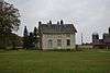 |
(#85002124) |
Creek Rd. 42°35′04″N 88°55′32″W / 42.584444°N 88.925556°W |
Tiffany | |
| 125 | Harrison Stebbins House | 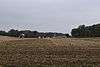 |
(#80000401) |
SR 1 42°49′36″N 89°12′55″W / 42.826667°N 89.215278°W |
Evansville | Demolished in 2013[6] |
| 126 | Soloman J. Strang House | 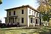 |
(#82000708) |
231 North Gilbert 42°40′25″N 89°12′32″W / 42.673611°N 89.208889°W |
Footville | |
| 127 | Strong Building | 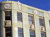 |
(#83003426) |
400-408 E. Grand Ave. 42°29′58″N 89°02′07″W / 42.499444°N 89.035278°W |
Beloit | |
| 128 | Strong Partridge Mound Group |  |
(#94000057) |
1750 Arrowhead Dr. 42°31′09″N 89°00′37″W / 42.519167°N 89.010278°W |
Beloit | |
| 129 | John and Eleanor Strunk House |  |
(#08000184) |
2306 N. Parker Dr. 42°42′38″N 89°01′59″W / 42.710556°N 89.033056°W |
Janesville | |
| 130 | Tallman House | 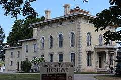 |
(#70000085) |
440 N. Jackson St. 42°41′10″N 89°01′53″W / 42.686111°N 89.031389°W |
Janesville | |
| 131 | A. E. Taylor House |  |
(#85001662) |
318 Durand St. 42°33′25″N 88°51′51″W / 42.556944°N 88.864167°W |
Clinton | |
| 132 | Turtleville Iron Bridge | .jpg) |
(#77000053) |
N of Beloit on Lathers Rd. 42°33′56″N 88°57′52″W / 42.565556°N 88.964444°W |
Beloit | |
| 133 | West Luther Valley Lutheran Church |  |
(#80000191) |
SW of Orfordville on W. Church Rd. 42°36′26″N 89°19′35″W / 42.607222°N 89.326389°W |
Orfordville | |
| 134 | West Milwaukee Street Historic District |  |
(#90000790) |
Roughly bounded by Wall, River, Court, and Academy Sts. 42°40′52″N 89°01′33″W / 42.681111°N 89.025833°W |
Janesville | |
| 135 | Whiton-Parker House |  |
(#15001056) |
1000 E. Milwaukee St. 42°41′17″N 89°00′45″W / 42.687966°N 89.012434°W |
Janesville | |
| 136 | Frances Willard Schoolhouse |  |
(#77000054) |
Craig Ave. 42°41′29″N 89°00′19″W / 42.691389°N 89.005278°W |
Janesville | |
| 137 | Wyman-Rye Farmstead |  |
(#77000055) |
N of Clinton on Wyman-Rye Dr. 42°35′28″N 88°52′18″W / 42.591111°N 88.871667°W |
Clinton | |
| 138 | Florence Yates House |  |
(#83003427) |
1614 Emerson St. 42°30′16″N 89°00′59″W / 42.504444°N 89.016389°W |
Beloit |
Formerly listed
| [3] | Name on the Register | Image | Date listed | Date removed | Location | City or town | Summary |
|---|---|---|---|---|---|---|---|
| 1 | Belle Cottage | Upload image | (#79000107) | 1837 Center Ave. |
Janesville | Gothic revival-styled house clad in local cobblestones, built by George Josiah Kellog in 1854. A.k.a. Damrow House. Demolished February 27, 1987.[7] | |
| 2 | Carlton Hotel | Upload image | (#88002173) | 14 N. Henry St. |
Edgerton | 3-story German Renaissance Revival hotel designed by Frank H. Kemp and built in 1898. Destroyed by fire in 1991.[8] | |
| 3 | Dean-Armstrong-Englund Octagonal Barn | Upload image | (#79003769) | |
Milton | Built in 1893.[9]:3 | |
| 4 | Dougan Round Barn | 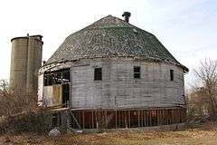 |
(#79000108) | 444 West Colley Rd. |
Beloit | Demolished in 2012.[10] | |
| 5 | J.B. Dow House and Carpenter Douglas Barn | Upload image | (#83003415) | 910 Board St. |
Beloit | The Dow house was a mix of Colonial Revival and Queen Anne styles, built in 1905. Dow was a realtor, lawyer and insurance salesman. Damaged by fire September 1996, demolished.[11] The 1847 barn is clad in cobblestone with limestone quoins.[12] | |
| 6 | Elijah Goodrich Wheat Warehouse | Upload image | (#78003389) | 602 E. Madison St. |
Milton | ||
| 7 | Leedle Mill Truss Bridge | 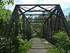 |
(#80000398) | SR 1 |
Evansville | ||
| 8 | Myers Opera House | Upload image | (#77001583) | 118 E. Milwaukee St. |
Janesville | Demolished in 1978. | |
| 9 | Wisconsin School for the Blind-Music Building | Upload image | (#87000440) | 1700 W. State St. |
Janesville | ||
| 10 | Wright-Amato House | Upload image | (#71001095) | 923 Mineral Point Ave. |
Janesville |
See also
| Wikimedia Commons has media related to National Register of Historic Places in Rock County, Wisconsin. |
- List of National Historic Landmarks in Wisconsin
- National Register of Historic Places listings in Wisconsin
References
- ↑ The latitude and longitude information provided is primarily from the National Register Information System, and has been found to be fairly accurate for about 99% of listings. For 1%, the location info may be way off. We seek to correct the coordinate information wherever it is found to be erroneous. Please leave a note in the Discussion page for this article if you believe any specific location is incorrect.
- ↑ "National Register of Historic Places: Weekly List Actions". National Park Service, United States Department of the Interior. Retrieved on December 2, 2016.
- 1 2 Numbers represent an ordering by significant words. Various colorings, defined here, differentiate National Historic Landmarks and historic districts from other NRHP buildings, structures, sites or objects.
- ↑ National Park Service (2008-04-24). "National Register Information System". National Register of Historic Places. National Park Service.
- ↑ The eight-digit number below each date is the number assigned to each location in the National Register Information System database, which can be viewed by clicking the number.
- ↑ Reed, Larry (December 7, 2013). "The Historic Stebbins House: R.I.P.". Retrieved October 16, 2016.
- ↑ "George Josiah Kellogg House (Belle Cottage)". Architecture and History Inventory. Wisconsin Historical Society. Retrieved 2014-09-02.
- ↑ "Carlton Hotel". Architecture and History Inventory. Wisconsin Historical Society. Retrieved 2014-09-02.
- ↑ Nancy Belle Douglas (November 10, 1978). "National Register of Historic Places Multiple Property Documentation: Centric Barns in Rock County TR" (PDF). National Park Service.
- ↑ http://www.beloitdailynews.com/news/historic-dougan-round-barn-demolished/article_92a45bf4-8a33-11e1-854c-001a4bcf887a.html
- ↑ "J. B. Dow House". Architecture and History Inventory. Wisconsin Historical Society. Retrieved 2014-09-02.
- ↑ "Carpenter-Douglas Barn". Architecture and History Inventory. Wisconsin Historical Society. Retrieved 2014-09-02.
External links
- Janesville's Benton Avenue Historic District: A Guide
- Janesville's Columbus Circle Historic District : A Guide
- Janesville's Court House Hill Historic District: A Guide
- Janesville's Look West Historic District: A Guide
- Main & Milwaukee, Janesville's Downtown Historic Districts: A Guide
- Janesville's Old Fourth Ward Historic District: A Guide
- Janesville's Prospect Hill & Conrad Cottages Historic Districts: A Guide
| Topics | |
|---|---|
| Lists by states |
|
| Lists by insular areas | |
| Lists by associated states | |
| Other areas | |
| |
Municipalities and communities of Rock County, Wisconsin, United States | ||
|---|---|---|
| Cities | | |
| Villages | ||
| Towns | ||
| CDP | ||
| Unincorporated communities |
| |
| Ghost towns | ||
| Footnotes | ‡This populated place also has portions in an adjacent county or counties | |
This article is issued from Wikipedia - version of the 10/23/2016. The text is available under the Creative Commons Attribution/Share Alike but additional terms may apply for the media files.