National Register of Historic Places listings in Sanders County, Montana

Location of Sanders County in Montana
This is a list of the National Register of Historic Places listings in Sanders County, Montana. It is intended to be a complete list of the properties and districts on the National Register of Historic Places in Sanders County, Montana, United States. The locations of National Register properties and districts for which the latitude and longitude coordinates are included below, may be seen in a map.[1]
There are 21 properties and districts listed on the National Register in the county.
- This National Park Service list is complete through NPS recent listings posted December 16, 2016.[2]
Listings county-wide
| [3] |
Name on the Register |
Image |
Date listed[4] |
Location |
City or town |
Description |
|---|
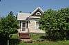
| 1 |
Ainsworth House |
Upload image |
000000001986-10-07-0000October 7, 1986
(#86002771) |
911 Maiden Ln.
47°35′43″N 115°21′19″W / 47.595278°N 115.355278°W / 47.595278; -115.355278 (Ainsworth House) |
Thompson Falls |
|
| 2 |
Bedard House |
Upload image |
000000001986-10-07-0000October 7, 1986
(#86002783) |
207 Spruce St.
47°35′50″N 115°20′43″W / 47.597222°N 115.345278°W / 47.597222; -115.345278 (Bedard House) |
Thompson Falls |
|
| 3 |
Bull River Guard Station |
Upload image |
000000001990-06-27-0000June 27, 1990
(#90000990) |
On the banks of the Bull River near its confluence with the E. Fork Bull River in the Kootenai National Forest
48°06′24″N 115°46′40″W / 48.106667°N 115.777778°W / 48.106667; -115.777778 (Bull River Guard Station) |
Noxon |
|
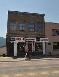
| 4 |
Gem Saloon |
|
000000001986-10-07-0000October 7, 1986
(#86002767) |
808 Main St.
47°35′40″N 115°20′45″W / 47.594444°N 115.345833°W / 47.594444; -115.345833 (Gem Saloon) |
Thompson Falls |
|
| 5 |
Grandchamp House |
|
000000001986-10-07-0000October 7, 1986
(#86002776) |
1012 Preston Ave.
47°35′51″N 115°21′10″W / 47.5975°N 115.352778°W / 47.5975; -115.352778 (Grandchamp House) |
Thompson Falls |
|
| 6 |
Griffen House |
Upload image |
000000001986-10-07-0000October 7, 1986
(#86002779) |
205 Gallatin St.
47°35′53″N 115°21′04″W / 47.598056°N 115.351111°W / 47.598056; -115.351111 (Griffen House) |
Thompson Falls |
|
| 7 |
House at 112 Park Street |
Upload image |
000000001986-10-07-0000October 7, 1986
(#86002778) |
112 Park St.
47°35′51″N 115°21′07″W / 47.5975°N 115.351944°W / 47.5975; -115.351944 (House at 112 Park Street) |
Thompson Falls |
|
| 8 |
House at 916 Preston Avenue |
Upload image |
000000001986-10-07-0000October 7, 1986
(#86002777) |
916 Preston Ave.
47°35′49″N 115°21′07″W / 47.596944°N 115.351944°W / 47.596944; -115.351944 (House at 916 Preston Avenue) |
Thompson Falls |
|
| 9 |
Hoyt House |
|
000000001986-10-07-0000October 7, 1986
(#86002780) |
204 Gallatin St.
47°35′52″N 115°20′59″W / 47.597778°N 115.349722°W / 47.597778; -115.349722 (Hoyt House) |
Thompson Falls |
|
| 10 |
IOOF Lodge |
|
000000001986-10-07-0000October 7, 1986
(#86002761) |
520 Main St.
47°35′35″N 115°20′31″W / 47.593056°N 115.341944°W / 47.593056; -115.341944 (IOOF Lodge) |
Thompson Falls |
|
| 11 |
Norby House |
Upload image |
000000001986-10-07-0000October 7, 1986
(#86002775) |
13 Pond St.
47°35′48″N 115°21′19″W / 47.596667°N 115.355278°W / 47.596667; -115.355278 (Norby House) |
Thompson Falls |
|
| 12 |
Northern Pacific Warehouse |
Upload image |
000000001986-10-07-0000October 7, 1986
(#86002785) |
Bounded by Preston Ave. and Main St. along the Burlington Northern right-of-way
47°35′42″N 115°20′33″W / 47.595°N 115.3425°W / 47.595; -115.3425 (Northern Pacific Warehouse) |
Thompson Falls |
|
| 13 |
Preston House |
|
000000001986-10-07-0000October 7, 1986
(#86002784) |
205 Ferry St.
47°35′45″N 115°20′30″W / 47.595833°N 115.341667°W / 47.595833; -115.341667 (Preston House) |
Thompson Falls |
|
| 14 |
Rinard House |
Upload image |
000000001986-10-07-0000October 7, 1986
(#86002782) |
210 Jefferson St.
47°35′50″N 115°20′50″W / 47.597222°N 115.347222°W / 47.597222; -115.347222 (Rinard House) |
Thompson Falls |
|
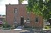
| 15 |
Sanders County Jail |
|
000000001986-10-07-0000October 7, 1986
(#86002774) |
Madison and Maiden Lane
47°35′42″N 115°21′00″W / 47.595°N 115.35°W / 47.595; -115.35 (Sanders County Jail) |
Thompson Falls |
|
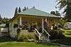
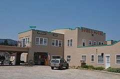
| 16 |
Symes Hotel |
|
000000001998-11-12-0000November 12, 1998
(#98001363) |
209 N. Wall St.
47°36′37″N 114°40′16″W / 47.610278°N 114.671111°W / 47.610278; -114.671111 (Symes Hotel) |
Hot Springs |
|
| 17 |
Thayer House |
Upload image |
000000001986-12-22-0000December 22, 1986
(#86002781) |
109 Jefferson St.
47°35′49″N 115°20′54″W / 47.596944°N 115.348333°W / 47.596944; -115.348333 (Thayer House) |
Thompson Falls |
|
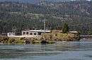
| 18 |
Thompson Falls Hydroelectric Dam Historic District |
|
000000001986-10-07-0000October 7, 1986
(#86002756) |
Alternate U.S. Route 10 at the Clark Fork River within the northwestern part of Thompson Falls
47°35′38″N 115°21′25″W / 47.593889°N 115.356944°W / 47.593889; -115.356944 (Thompson Falls Hydroelectric Dam Historic District) |
Thompson Falls |
|
| 19 |
Tourist Hotel |
Upload image |
000000001986-10-07-0000October 7, 1986
(#86002765) |
101 Main St.
47°35′40″N 115°20′41″W / 47.594444°N 115.344722°W / 47.594444; -115.344722 (Tourist Hotel) |
Thompson Falls |
|
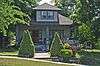
| 20 |
Ward Hotel |
|
000000001986-12-22-0000December 22, 1986
(#86002769) |
919 Main St.
47°35′41″N 115°20′48″W / 47.594722°N 115.346667°W / 47.594722; -115.346667 (Ward Hotel) |
Thompson Falls |
|
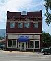
| 21 |
Weber's Store |
Upload image |
000000001986-10-07-0000October 7, 1986
(#86002763) |
510 Main St.
47°35′37″N 115°20′34″W / 47.593611°N 115.342778°W / 47.593611; -115.342778 (Weber's Store) |
Thompson Falls |
|
See also
References
- ↑ The latitude and longitude information provided in this table was derived originally from the National Register Information System, which has been found to be fairly accurate for about 99% of listings. For about 1% of NRIS original coordinates, experience has shown that one or both coordinates are typos or otherwise extremely far off; some corrections may have been made. A more subtle problem causes many locations to be off by up to 150 yards, depending on location in the country: most NRIS coordinates were derived from tracing out latitude and longitudes off of USGS topographical quadrant maps created under the North American Datum of 1927, which differs from the current, highly accurate WGS84 GPS system used by most on-line maps. Chicago is about right, but NRIS longitudes in Washington are higher by about 4.5 seconds, and are lower by about 2.0 seconds in Maine. Latitudes differ by about 1.0 second in Florida. Some locations in this table may have been corrected to current GPS standards.
- ↑ "National Register of Historic Places: Weekly List Actions". National Park Service, United States Department of the Interior. Retrieved on December 16, 2016.
- ↑ Numbers represent an ordering by significant words. Various colorings, defined here, differentiate National Historic Landmarks and historic districts from other NRHP buildings, structures, sites or objects.
- ↑ The eight-digit number below each date is the number assigned to each location in the National Register Information System database, which can be viewed by clicking the number.
|
|---|
|
| Topics | |
|---|
|
| Lists by states | |
|---|
|
| Lists by insular areas | |
|---|
|
| Lists by associated states | |
|---|
|
| Other areas | |
|---|
|
-
 Portal Portal
-
 WikiProject WikiProject
|