| [3] |
Name on the Register[4] |
Image |
Date listed[5] |
Location |
City or town |
Description |
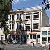
|---|
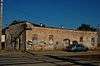
| 1 |
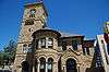
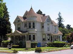
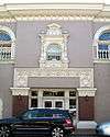
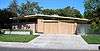
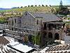
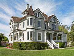
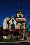
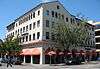
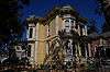
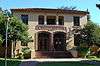
Agnews Insane Asylum |
|
000000001997-08-13-0000August 13, 1997
(#97000829) |
4000 Lafayette Ave.
37°23′38″N 121°57′10″W / 37.393889°N 121.952778°W / 37.393889; -121.952778 (Agnews Insane Asylum) |
Santa Clara |
|
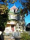
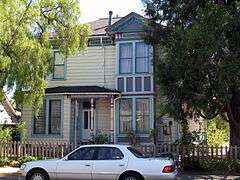
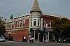
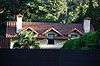
| 2 |
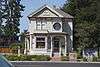
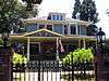
John Colpitts Ainsley House No. 3 |
|
000000002005-10-03-0000October 3, 2005
(#05001086) |
300 Grant St.
37°17′26″N 121°56′37″W / 37.290556°N 121.943611°W / 37.290556; -121.943611 (John Colpitts Ainsley House No. 3) |
Campbell |
|
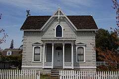
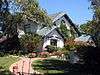
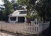
| 3 |
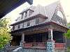
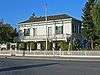
Theophilus Allen House |
|
000000001999-05-20-0000May 20, 1999
(#99000580) |
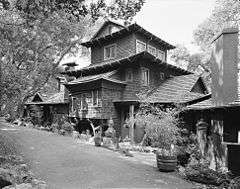
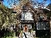
601 Melville Ave.
37°26′37″N 122°08′53″W / 37.44356°N 122.14809°W / 37.44356; -122.14809 (Theophilus Allen House) |
Palo Alto |
|
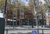
| 4 |
Alviso Historic District |
|
000000001973-10-09-0000October 9, 1973
(#73000449) |
Generally bounded by the Alviso Marina County Park, Guadalupe River/Alviso Slough, Moffat St. and El Dorado St.[6]
37°25′30″N 121°58′00″W / 37.425°N 121.966667°W / 37.425; -121.966667 (Alviso Historic District) |
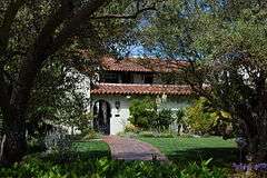
Alviso |
|
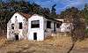
| 5 |
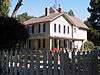
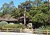
Jose Maria Alviso Adobe |
|
000000001997-10-07-0000October 7, 1997
(#97001190) |
92 Piedmont Rd.
37°26′17″N 121°52′08″W / 37.438056°N 121.868889°W / 37.438056; -121.868889 (Jose Maria Alviso Adobe) |
Milpitas |
|
| 6 |
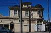
Ashworth-Remillard House |
|
000000001976-12-12-0000December 12, 1976
(#76000529) |
755 Story Rd.
37°19′43″N 121°51′34″W / 37.328611°N 121.859444°W / 37.328611; -121.859444 (Ashworth-Remillard House) |
San Jose |
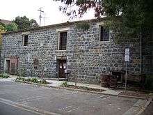
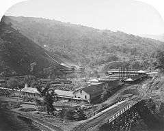
|
| 7 |
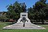
Building at 27-29 Fountain Alley |
|
000000001982-03-02-0000March 2, 1982
(#82002265) |
27-29 Fountain Alley
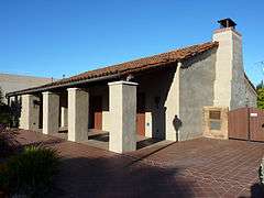
37°20′16″N 121°54′46″W / 37.337778°N 121.912778°W / 37.337778; -121.912778 (Building at 27-29 Fountain Alley) |
San Jose |
|
| 8 |
Campbell Union Grammar School |
|
000000001979-07-20-0000July 20, 1979
(#79000544) |
11 E. Campbell Ave.
37°17′16″N 121°56′52″W / 37.287778°N 121.947778°W / 37.287778; -121.947778 (Campbell Union Grammar School) |
Campbell |
|
| 9 |
Campbell Union High School Historic District |
|
000000001989-08-17-0000August 17, 1989
(#89001048) |
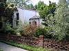
1 W. Campbell Ave.
37°17′13″N 121°57′14″W / 37.286994°N 121.953864°W / 37.286994; -121.953864 (Campbell Union High School Historic District) |
Campbell |
|
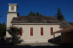
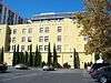
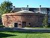
| 10 |
Christian Church of Gilroy |
|
000000001982-04-01-0000April 1, 1982
(#82002261) |
160 5th St.
37°00′28″N 121°34′14″W / 37.007778°N 121.570556°W / 37.007778; -121.570556 (Christian Church of Gilroy) |
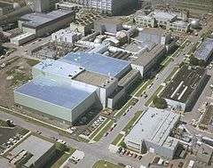
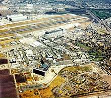
Gilroy |
|
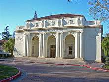
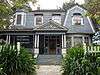
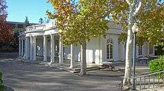
| 11 |
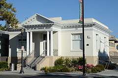
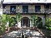
Civic Art Gallery |
|
000000001973-01-29-0000January 29, 1973
(#73000453) |
110 Market St.
37°20′01″N 121°53′21″W / 37.333611°N 121.889167°W / 37.333611; -121.889167 (Civic Art Gallery) |
San Jose |
|
| 12 |
Coyote Creek Archeological District |
Upload image |
000000001971-10-14-0000October 14, 1971
(#71000192) |
Address Restricted
|
Gilroy Hot Springs |
|
| 13 |
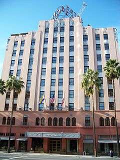
De Anza Hotel |
|
000000001982-01-21-0000January 21, 1982
(#82002266) |
233 W. Santa Clara St.
37°20′04″N 121°53′38″W / 37.334444°N 121.893889°W / 37.334444; -121.893889 (De Anza Hotel) |
San Jose |
|
| 14 |
Pedro de Lemos House |
|
000000001980-01-10-0000January 10, 1980
(#80000863) |
100-110 Waverley Oaks
37°26′01″N 122°08′24″W / 37.433515°N 122.140031°W / 37.433515; -122.140031 (Pedro de Lemos House) |
Palo Alto |
|
| 15 |
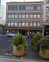
Dohrmann Building |
|
000000001986-02-20-0000February 20, 1986
(#86000264) |
325 S. First St.
37°19′52″N 121°53′09″W / 37.331111°N 121.885833°W / 37.331111; -121.885833 (Dohrmann Building) |
San Jose |
|
| 16 |
T. B. Downing House |
|
000000001973-10-30-0000October 30, 1973
(#73000452) |
706 Cowper St.
37°26′48″N 122°09′24″W / 37.44655°N 122.156727°W / 37.44655; -122.156727 (T. B. Downing House) |
Palo Alto |
|
| 17 |
Dunker House |
|
000000001982-02-19-0000February 19, 1982
(#82002264) |
420 Maple St.
37°27′25″N 122°08′59″W / 37.456924°N 122.149678°W / 37.456924; -122.149678 (Dunker House) |
Palo Alto |
|
| 18 |
East San Jose Carnegie Library |
|
000000001990-12-10-0000December 10, 1990
(#90001813) |
1102 E. Santa Clara St.
37°20′49″N 121°52′03″W / 37.346944°N 121.8675°W / 37.346944; -121.8675 (East San Jose Carnegie Library) |
San Jose |
|
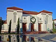
| 19 |
First Unitarian Universalist Church |
|
000000001977-11-17-0000November 17, 1977
(#77000343) |
160 N. 3rd St.
37°20′23″N 121°53′20″W / 37.339722°N 121.888889°W / 37.339722; -121.888889 (First Unitarian Universalist Church) |
San Jose |
|
| 20 |
Forbes Mill Annex |
|
000000001978-07-31-0000July 31, 1978
(#78000776) |
75 Church St.
37°13′20″N 121°58′50″W / 37.222277°N 121.980515°W / 37.222277; -121.980515 (Forbes Mill Annex) |
Los Gatos |
|
| 21 |
Fraternal Hall Building |
|
000000001990-02-15-0000February 15, 1990
(#90000119) |
140 University Ave. and 514 High St.
37°26′40″N 122°09′45″W / 37.444429°N 122.162628°W / 37.444429; -122.162628 (Fraternal Hall Building) |
Palo Alto |
|
| 22 |
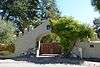
Arthur Monroe Free House |
|
000000002002-04-26-0000April 26, 2002
(#02000384) |
66 S. 14th St.
37°20′32″N 121°52′31″W / 37.342222°N 121.875278°W / 37.342222; -121.875278 (Arthur Monroe Free House) |
San Jose |
|
| 23 |
Galindo-Leigh House |
|
000000001980-08-22-0000August 22, 1980
(#80000857) |
140 S. Peter Dr.
37°17′06″N 121°55′21″W / 37.285°N 121.9225°W / 37.285; -121.9225 (Galindo-Leigh House) |
Campbell |
|
| 24 |
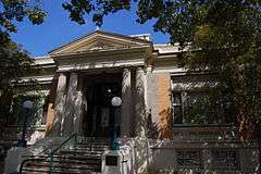
Gilroy Free Library |
|
000000001988-06-23-0000June 23, 1988
(#88000923) |
195 Fifth St.
37°00′29″N 121°34′18″W / 37.007925°N 121.571651°W / 37.007925; -121.571651 (Gilroy Free Library) |
Gilroy |
|
| 25 |
Gilroy Yamato Hot Springs |
Upload image |
000000001995-08-21-0000August 21, 1995
(#95000996) |
9.5 miles (15.3 km) northeast of the junction of New Ave. and Roop Rd.
37°06′30″N 121°28′39″W / 37.108333°N 121.4775°W / 37.108333; -121.4775 (Gilroy Yamato Hot Springs) |
Gilroy |
|
| 26 |
Green Gables |
|
000000002005-07-28-0000July 28, 2005
(#04000863) |
Channing Ave., Ivy Ln., Greer Rd., Wildwood Ln.
37°26′45″N 122°07′27″W / 37.445833°N 122.124167°W / 37.445833; -122.124167 (Green Gables) |
Palo Alto |
community of Eichler homes
|
| 27 |
Greenmeadow |
|
000000002005-07-28-0000July 28, 2005
(#04000862) |
Nelson Dr., El Capitan Pl., Adobe Pl., Creekside Dr.
37°24′53″N 122°06′45″W / 37.414772°N 122.112569°W / 37.414772; -122.112569 (Greenmeadow) |
Palo Alto |
community of Eichler homes
|
| 28 |
Willard Griffin House and Carriage House |
|
000000001977-04-13-0000April 13, 1977
(#77000342) |
12345 S. El Monte Ave.
37°21′43″N 122°07′30″W / 37.361892°N 122.125008°W / 37.361892; -122.125008 (Willard Griffin House and Carriage House) |
Los Altos |
|
| 29 |
Hakone Historic District |
|
000000002013-04-23-0000April 23, 2013
(#13000181) |
21000 Big Basin Way
37°15′15″N 122°02′22″W / 37.25403°N 122.039503°W / 37.25403; -122.039503 (Hakone Historic District) |
Saratoga |
|
| 30 |
Capt. James A. Hamilton House |
|
000000001980-06-09-0000June 9, 1980
(#80000864) |
2295 S. Bascom Ave.
37°16′54″N 121°55′52″W / 37.281667°N 121.931111°W / 37.281667; -121.931111 (Capt. James A. Hamilton House) |
San Jose |
|
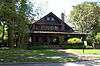
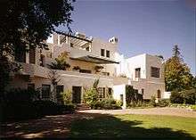
| 31 |
Hanna-Honeycomb House |
|
000000001978-11-07-0000November 7, 1978
(#78000780) |
737 Frenchman's Rd.
37°25′00″N 122°09′45″W / 37.416667°N 122.1625°W / 37.416667; -122.1625 (Hanna-Honeycomb House) |
Stanford |
1937 house by Frank Lloyd Wright
|
| 32 |
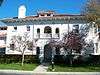
Hayes Mansion |
|
000000001975-08-01-0000August 1, 1975
(#75000481) |
200 Edenvale Ave.
37°15′45″N 121°49′11″W / 37.2625°N 121.819722°W / 37.2625; -121.819722 (Hayes Mansion) |
San Jose |
|
| 33 |
Hensley Historic District |
|
000000001983-06-21-0000June 21, 1983
(#83001238) |
Roughly bounded by Julian, 1st, 7th, and Empire Sts.
37°20′40″N 121°53′29″W / 37.344444°N 121.891389°W / 37.344444; -121.891389 (Hensley Historic District) |
San Jose |
|
| 34 |
Hewlett-Packard House and Garage |
|
000000002007-04-20-0000April 20, 2007
(#07000307) |
367 Addison Ave.
37°26′35″N 122°09′17″W / 37.44299°N 122.154613°W / 37.44299; -122.154613 (Hewlett-Packard House and Garage) |
Palo Alto |
|
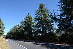
| 35 |
Highway 152 Tree Row |
|
000000002007-07-03-0000July 3, 2007
(#07000635) |
California State Route 152 between Uvas Creek Bridge and Santa Teresa Blvd
37°00′43″N 121°36′47″W / 37.011909°N 121.613045°W / 37.011909; -121.613045 (Highway 152 Tree Row) |
Gilroy |
|
| 36 |
Edgar Holloway House |
|
000000001982-01-28-0000January 28, 1982
(#82002262) |
7539 Eigleberry St.
37°00′31″N 121°34′16″W / 37.008696°N 121.571175°W / 37.008696; -121.571175 (Edgar Holloway House) |
Gilroy |
|
| 37 |
Lou Henry Hoover House |
|
000000001978-01-30-0000January 30, 1978
(#78000786) |
623 Mirada Rd.
37°25′05″N 122°10′04″W / 37.418056°N 122.167778°W / 37.418056; -122.167778 (Lou Henry Hoover House) |
Stanford |
|
| 38 |
Hostess House |
|
000000001976-07-30-0000July 30, 1976
(#76000528) |
University Ave. at El Camino Real
37°26′35″N 122°09′56″W / 37.443066°N 122.165524°W / 37.443066; -122.165524 (Hostess House) |
Palo Alto |
|
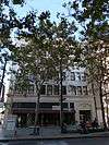
| 39 |
Hotel Montgomery |
|
000000002006-04-20-0000April 20, 2006
(#06000328) |
211 SW First St.
37°19′57″N 121°53′15″W / 37.3325°N 121.8875°W / 37.3325; -121.8875 (Hotel Montgomery) |
San Jose |
|
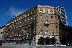
| 40 |
Hotel Sainte Claire |
|
000000001980-06-03-0000June 3, 1980
(#80000865) |
302 and 320 S. Market St.
37°20′13″N 121°52′58″W / 37.336944°N 121.882778°W / 37.336944; -121.882778 (Hotel Sainte Claire) |
San Jose |
|
| 41 |
Warner Hutton House |
|
000000002006-03-17-0000March 17, 2006
(#06000189) |
13777a Fruitvale Ave.
37°16′05″N 122°00′52″W / 37.268172°N 122.014317°W / 37.268172; -122.014317 (Warner Hutton House) |
Saratoga |
|
| 42 |
Kee House |
|
000000001985-04-11-0000April 11, 1985
(#85000715) |
2310 Yale St.
37°25′27″N 122°08′47″W / 37.424167°N 122.146389°W / 37.424167; -122.146389 (Kee House) |
Palo Alto |
1889 Eastlake-style house
|
| 43 |
Kotani-En Garden |
Upload image |
000000001976-11-07-0000November 7, 1976
(#76000527) |
15891 Ravine Road[7]
37°14′14″N 122°00′41″W / 37.237098°N 122.011435°W / 37.237098; -122.011435 (Kotani-En Garden) |
Los Gatos |
|
| 44 |
Andrew J. Landrum House |
|
000000001982-02-19-0000February 19, 1982
(#82002271) |
1219 Santa Clara St.
37°20′50″N 121°56′52″W / 37.347222°N 121.947778°W / 37.347222; -121.947778 (Andrew J. Landrum House) |
Santa Clara |
|
| 45 |
Lantarnam Hall |
Upload image |
000000001985-12-19-0000December 19, 1985
(#85003189) |
12335 Stonebrook Ct.
37°21′24″N 122°07′31″W / 37.356777°N 122.125373°W / 37.356777; -122.125373 (Lantarnam Hall) |
Los Altos Hills |
|
| 46 |
Le Petit Trianon |
|
000000001972-11-15-0000November 15, 1972
(#72001552) |
De Anza College campus
37°19′15″N 122°02′50″W / 37.320828°N 122.047222°W / 37.320828; -122.047222 (Le Petit Trianon) |
Cupertino |
|
| 47 |
Leib Carriage House |
|
000000001980-06-02-0000June 2, 1980
(#80000866) |
60 N. Keeble Ave.
37°19′59″N 121°54′29″W / 37.333056°N 121.908056°W / 37.333056; -121.908056 (Leib Carriage House) |
San Jose |
|
| 48 |
James Lick Mill |
|
000000001982-03-02-0000March 2, 1982
(#82002272) |
305 Montague Expwy.
37°23′59″N 121°56′30″W / 37.399722°N 121.941667°W / 37.399722; -121.941667 (James Lick Mill) |
Santa Clara |
|
| 49 |
Live Oak Creamery |
|
000000001982-03-11-0000March 11, 1982
(#82002263) |
88 Martin St.
37°00′30″N 121°34′05″W / 37.008322°N 121.568147°W / 37.008322; -121.568147 (Live Oak Creamery) |
Gilroy |
|
| 50 |
Los Gatos Historic Commercial District |
|
000000001991-09-13-0000September 13, 1991
(#91001382) |
1-24 N. Santa Cruz Ave., 9-15 University Ave. and 14-198 W. Main St.
37°13′19″N 121°58′58″W / 37.221944°N 121.982778°W / 37.221944; -121.982778 (Los Gatos Historic Commercial District) |
Los Gatos |
|
| 51 |
MacFarland House |
|
000000002006-07-21-0000July 21, 2006
(#06000659) |
775 Santa Ynez St.
37°25′01″N 122°10′07″W / 37.416944°N 122.168611°W / 37.416944; -122.168611 (MacFarland House) |
Stanford |
|
| 52 |
Malaguerra Winery |
|
000000001980-10-23-0000October 23, 1980
(#80000858) |
N. of Morgan Hill on Burnett Ave.
37°10′09″N 121°39′19″W / 37.169191°N 121.6554°W / 37.169191; -121.6554 (Malaguerra Winery) |
Morgan Hill |
|
| 53 |
Paul Masson Mountain Winery |
|
000000001983-06-09-0000June 9, 1983
(#83001239) |
Pierce Rd.
37°15′37″N 122°03′53″W / 37.260161°N 122.064791°W / 37.260161; -122.064791 (Paul Masson Mountain Winery) |
Saratoga |
|
| 54 |
McCullagh-Jones House |
|
000000001974-10-29-0000October 29, 1974
(#74000558) |
18000 Overlook Rd.
37°13′37″N 121°59′37″W / 37.226987°N 121.993615°W / 37.226987; -121.993615 (McCullagh-Jones House) |
Los Gatos |
|
| 55 |
Miller Red Barn |
Upload image |
000000002016-09-26-0000September 26, 2016
(#16000665) |
7049 Miller Ave.
36°59′54″N 121°35′18″W / 36.998288°N 121.588385°W / 36.998288; -121.588385 (Miller Red Barn) |
Gilroy |
|
| 56 |
Miller-Melone Ranch |
|
000000001993-04-01-0000April 1, 1993
(#93000260) |
12795 Saratoga-Sunnyvale Rd.
37°16′57″N 122°01′58″W / 37.282499°N 122.032915°W / 37.282499; -122.032915 (Miller-Melone Ranch) |
Saratoga |
|
| 57 |
Milpitas Grammar School |
|
000000001993-07-22-0000July 22, 1993
(#93000667) |
160 N. Main St.
37°25′59″N 121°54′21″W / 37.433056°N 121.905833°W / 37.433056; -121.905833 (Milpitas Grammar School) |
Milpitas |
|
| 58 |
Moir Building |
|
000000001982-10-29-0000October 29, 1982
(#82000991) |
227-247 N. 1st St.
37°20′23″N 121°53′32″W / 37.339722°N 121.892222°W / 37.339722; -121.892222 (Moir Building) |
San Jose |
|
| 59 |
Charles Copeland Morse House |
|
000000001977-04-13-0000April 13, 1977
(#77000347) |
981 Fremont St.
37°21′08″N 121°56′41″W / 37.352222°N 121.944722°W / 37.352222; -121.944722 (Charles Copeland Morse House) |
Santa Clara |
|
| 60 |
Mountain View Adobe |
|
000000002002-10-28-0000October 28, 2002
(#02001256) |
157 Moffett Blvd.
37°23′45″N 122°04′37″W / 37.395833°N 122.076944°W / 37.395833; -122.076944 (Mountain View Adobe) |
Mountain View |
|
| 61 |
New Almaden |
|
000000001966-10-15-0000October 15, 1966
(#66000236) |
14 miles (23 km) south of San Jose on CR G8
37°10′48″N 121°50′08″W / 37.18°N 121.835556°W / 37.18; -121.835556 (New Almaden) |
San Jose |
|
| 62 |
Norris House |
|
000000001980-07-24-0000July 24, 1980
(#80000859) |
1247 Cowper St.
37°26′33″N 122°08′57″W / 37.442461°N 122.149281°W / 37.442461; -122.149281 (Norris House) |
Palo Alto |
|
| 63 |
Frank Norris Cabin |
|
000000001966-10-15-0000October 15, 1966
(#66000235) |
10 miles (16 km) west of Gilroy off CA 152
37°02′11″N 121°42′45″W / 37.036389°N 121.7125°W / 37.036389; -121.7125 (Frank Norris Cabin) |
Gilroy |
|
| 64 |
Old City Hall |
|
000000001975-04-16-0000April 16, 1975
(#75000480) |
7410 Monterey St.
37°00′26″N 121°34′07″W / 37.007122°N 121.568544°W / 37.007122; -121.568544 (Old City Hall) |
Gilroy |
|
| 65 |
Palo Alto Medical Clinic |
|
000000002010-06-21-0000June 21, 2010
(#10000357) |
300 Homer Ave.
37°26′37″N 122°09′26″W / 37.443663°N 122.157252°W / 37.443663; -122.157252 (Palo Alto Medical Clinic) |
Palo Alto |
|
| 66 |
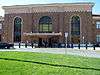
Palo Alto Southern Pacific Railroad Depot |
|
000000001996-04-18-0000April 18, 1996
(#96000425) |
95 University Ave.
37°26′37″N 122°09′55″W / 37.443492°N 122.165245°W / 37.443492; -122.165245 (Palo Alto Southern Pacific Railroad Depot) |
Palo Alto |
|
| 67 |
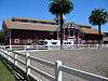
Palo Alto Stock Farm Horse Barn |
|
000000001985-12-12-0000December 12, 1985
(#85003325) |
Fremont Rd.
37°25′29″N 122°11′00″W / 37.424722°N 122.183333°W / 37.424722; -122.183333 (Palo Alto Stock Farm Horse Barn) |
Stanford |
|
| 68 |
Luis Maria Peralta Adobe |
|
000000001973-10-15-0000October 15, 1973
(#73000454) |
184 W. St. John St.
37°20′11″N 121°53′36″W / 37.336389°N 121.893333°W / 37.336389; -121.893333 (Luis Maria Peralta Adobe) |
San Jose |
|
| 69 |
Pettigrew House |
|
000000001980-11-25-0000November 25, 1980
(#80000860) |
1336 Cowpers St.
37°26′29″N 122°08′51″W / 37.441389°N 122.1475°W / 37.441389; -122.1475 (Pettigrew House) |
Palo Alto |
|
| 70 |
Picchetti Brothers Winery |
|
000000001979-05-10-0000May 10, 1979
(#79000545) |
Southwest of Cupertino at 13100 Montebello Rd.
37°17′40″N 122°05′26″W / 37.29451°N 122.090561°W / 37.29451; -122.090561 (Picchetti Brothers Winery) |
Cupertino |
|
| 71 |
Poverty Flat Site |
Upload image |
000000001972-02-23-0000February 23, 1972
(#72000254) |
Address Restricted
|
Morgan Hill |
|
| 72 |
Professorville Historic District |
|
000000001980-10-03-0000October 3, 1980
(#80000861) |
Roughly bounded by Embarcadero Rd., Addison Ave., Emerson and Cowper Sts.
37°26′29″N 122°09′05″W / 37.441389°N 122.151389°W / 37.441389; -122.151389 (Professorville Historic District) |
Palo Alto |
|
| 73 |
Ramona Street Architectural District |
|
000000001986-03-27-0000March 27, 1986
(#86000592) |
518-581 Ramona St. and 255-267 Hamilton Ave.
37°26′42″N 122°09′42″W / 37.444889°N 122.161555°W / 37.444889; -122.161555 (Ramona Street Architectural District) |
Palo Alto |
|
| 74 |
Henry A. Rengstorff House |
|
000000001978-06-13-0000June 13, 1978
(#78000778) |
3070 N. Shoreline Blvd.
37°25′54″N 122°05′13″W / 37.431608°N 122.086991°W / 37.431608; -122.086991 (Henry A. Rengstorff House) |
Mountain View |
|
| 75 |
Ernest & Emily Renzel House |
|
000000002010-09-23-0000September 23, 2010
(#10000773) |
120 Arroyo Way
37°20′32″N 121°52′18″W / 37.342222°N 121.871667°W / 37.342222; -121.871667 (Ernest & Emily Renzel House) |
San Jose |
|
| 76 |
Rhoades Ranch |
Upload image |
000000002013-04-17-0000April 17, 2013
(#13000158) |
2290-A Cochrane Road
37°09′51″N 121°37′54″W / 37.164256°N 121.631753°W / 37.164256; -121.631753 (Rhoades Ranch) |
Morgan Hill |
|
| 77 |
Roberto-Sunol Adobe |
|
000000001977-03-17-0000March 17, 1977
(#77000344) |
770 Lincoln Ave.
37°18′59″N 121°54′22″W / 37.316389°N 121.906111°W / 37.316389; -121.906111 (Roberto-Sunol Adobe) |
San Jose |
|
| 78 |
Roma Bakery |
|
000000001982-01-21-0000January 21, 1982
(#82002267) |
655 Almaden Ave.
37°20′33″N 121°53′07″W / 37.3425°N 121.885278°W / 37.3425; -121.885278 (Roma Bakery) |
San Jose |
|
| 79 |
Ross House |
|
000000001982-10-29-0000October 29, 1982
(#82000992) |
693 S. 2nd St.
37°19′35″N 121°52′51″W / 37.326389°N 121.880833°W / 37.326389; -121.880833 (Ross House) |
San Jose |
|
| 80 |
St. James Square Historic District |
|
000000001979-11-27-0000November 27, 1979
(#79000546) |
Roughly bounded by N. 1st, N. 4th, E. St. James, and E. St. John Sts.
37°20′20″N 121°53′25″W / 37.338889°N 121.890278°W / 37.338889; -121.890278 (St. James Square Historic District) |
San Jose |
|
| 81 |
St. Joseph's Roman Catholic Church |
|
000000001977-08-26-0000August 26, 1977
(#77000345) |
Market and San Fernando Sts.
37°20′03″N 121°53′22″W / 37.334167°N 121.889444°W / 37.334167; -121.889444 (St. Joseph's Roman Catholic Church) |
San Jose |
|
| 82 |
San Jose Central Fire Station |
Upload image |
000000002015-01-07-0000January 7, 2015
(#14001113) |
201 N. Market St.
37°20′19″N 121°53′40″W / 37.3387°N 121.8945°W / 37.3387; -121.8945 (San Jose Central Fire Station) |
San Jose |
|
| 83 |
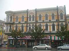
San Jose Downtown Historic District |
|
000000001983-05-26-0000May 26, 1983
(#83003822) |
E. Santa Clara, South First, Second, Third and E. San Fernando Sts.
37°20′10″N 121°53′15″W / 37.336111°N 121.8875°W / 37.336111; -121.8875 (San Jose Downtown Historic District) |
San Jose |
|
| 84 |
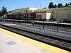
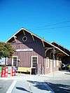
Santa Clara Depot |
|
000000001985-02-28-0000February 28, 1985
(#85000359) |
1 Railroad Ave.
37°21′11″N 121°56′06″W / 37.353056°N 121.935°W / 37.353056; -121.935 (Santa Clara Depot) |
Santa Clara |
|
| 85 |
Santa Clara Verein |
|
000000001984-01-19-0000January 19, 1984
(#84001199) |
1082 Alviso St.
37°21′05″N 121°56′29″W / 37.351389°N 121.941389°W / 37.351389; -121.941389 (Santa Clara Verein) |
Santa Clara |
Demolished in 1991
|
| 86 |
Saratoga Foothill Club |
|
000000002005-02-27-0000February 27, 2005
(#05000069) |
20399 Park Place
37°15′33″N 122°01′48″W / 37.259055°N 122.029959°W / 37.259055; -122.029959 (Saratoga Foothill Club) |
Saratoga |
1915 Arts and Crafts-style clubhouse designed by Julia Morgan
|
| 87 |
Saratoga Village Library |
|
000000002007-01-17-0000January 17, 2007
(#06001238) |
14410 Oak St.
37°15′28″N 122°01′53″W / 37.257911°N 122.03129°W / 37.257911; -122.03129 (Saratoga Village Library) |
Saratoga |
now a used book store benefiting the Saratoga Library
|
| 88 |
Paul Shoup House |
|
000000002011-09-23-0000September 23, 2011
(#11000696) |
500 University Ave.
37°22′25″N 122°07′07″W / 37.373611°N 122.118611°W / 37.373611; -122.118611 (Paul Shoup House) |
Los Altos |
|
| 89 |
Southern Pacific Depot |
|
000000001993-04-01-0000April 1, 1993
(#93000274) |
65 Cahill St.
37°19′49″N 121°54′06″W / 37.330278°N 121.901667°W / 37.330278; -121.901667 (Southern Pacific Depot) |
San Jose |
|
| 90 |
Spillman Engineering 3-Abreast Carousel |
Upload image |
000000002000-04-13-0000April 13, 2000
(#00000366) |
139 B Eastridge Mall
37°19′33″N 121°48′47″W / 37.325833°N 121.813056°W / 37.325833; -121.813056 (Spillman Engineering 3-Abreast Carousel) |
San Jose |
|
| 91 |
John Adam Squire House |
|
000000001972-03-06-0000March 6, 1972
(#72000255) |
900 University Ave.
37°27′11″N 122°09′14″W / 37.453185°N 122.153755°W / 37.453185; -122.153755 (John Adam Squire House) |
Palo Alto |
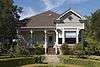
|
| 92 |
John Steinbeck House |
Upload image |
000000001989-12-28-0000December 28, 1989
(#89002117) |
16250 Greenwood Ln.
37°13′55″N 122°00′07″W / 37.23206°N 122.002011°W / 37.23206; -122.002011 (John Steinbeck House) |
Monte Sereno |
|
| 93 |
Troy Laundry |
Upload image |
000000001982-01-28-0000January 28, 1982
(#82002268) |
722 Almaden Ave.
37°19′26″N 121°53′04″W / 37.323889°N 121.884444°W / 37.323889; -121.884444 (Troy Laundry) |
San Jose |
no longer exists; Troy Apartments now occupy this location
|
| 94 |
Twohy Building |
|
000000002003-10-06-0000October 6, 2003
(#03000989) |
210 S. First St.
37°19′59″N 121°53′12″W / 37.333056°N 121.886667°W / 37.333056; -121.886667 (Twohy Building) |
San Jose |
|
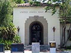
| 95 |
U.S. Post Office |
|
000000001981-04-05-0000April 5, 1981
(#81000175) |
380 Hamilton Ave.
37°26′45″N 122°09′33″W / 37.445911°N 122.159141°W / 37.445911; -122.159141 (U.S. Post Office) |
Palo Alto |
|
| 96 |
Unitary Plan Wind Tunnel |
|
000000001985-10-03-0000October 3, 1985
(#85002799) |
Ames Research Center
37°25′03″N 122°03′35″W / 37.4175°N 122.059722°W / 37.4175; -122.059722 (Unitary Plan Wind Tunnel) |
Moffett Field |
|
| 97 |
US Naval Air Station Sunnyvale, California, Historic District |
|
000000001994-02-24-0000February 24, 1994
(#94000045) |
Moffett Federal Airfield
37°24′46″N 122°03′13″W / 37.412778°N 122.053611°W / 37.412778; -122.053611 (US Naval Air Station Sunnyvale, California, Historic District) |
Sunnyvale |
NASA Ames Historic Properties[8]
|
| 98 |
Villa Mira Monte |
|
000000001978-05-25-0000May 25, 1978
(#78000777) |
17860 Monterey Rd.
37°08′05″N 121°39′26″W / 37.134811°N 121.657309°W / 37.134811; -121.657309 (Villa Mira Monte) |
Morgan Hill |
|
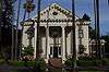
| 99 |
Villa Montalvo |
|
000000001978-05-01-0000May 1, 1978
(#78000784) |
14800 Montalvo Rd.
37°14′38″N 122°01′52″W / 37.243875°N 122.03106°W / 37.243875; -122.03106 (Villa Montalvo) |
Saratoga |
|
| 100 |
We and Our Neighbors Clubhouse |
|
000000001978-12-20-0000December 20, 1978
(#78000781) |
South of San Jose at 15460 Union Ave.
37°14′37″N 121°55′52″W / 37.243714°N 121.931072°W / 37.243714; -121.931072 (We and Our Neighbors Clubhouse) |
San Jose |
|
| 101 |
Welch-Hurst |
|
000000001978-09-18-0000September 18, 1978
(#78000785) |
15800 Sanborn Rd.
37°14′22″N 122°04′22″W / 37.239349°N 122.072681°W / 37.239349; -122.072681 (Welch-Hurst) |
Saratoga |
most recently known as the Sanborn Park Hostel; closed in March 2010[9]
|
| 102 |
Wheeler Hospital |
|
000000001990-09-13-0000September 13, 1990
(#90001442) |
650 Fifth St.
37°00′23″N 121°34′38″W / 37.006254°N 121.577311°W / 37.006254; -121.577311 (Wheeler Hospital) |
Gilroy |
|
| 103 |
Wilson House |
|
000000001980-01-02-0000January 2, 1980
(#80000862) |
860 University St.
37°27′09″N 122°09′16″W / 37.452563°N 122.154431°W / 37.452563; -122.154431 (Wilson House) |
Palo Alto |
|
| 104 |
Winchester House |
|
000000001974-08-07-0000August 7, 1974
(#74000559) |
525 S. Winchester Blvd.
37°19′05″N 121°57′00″W / 37.318056°N 121.95°W / 37.318056; -121.95 (Winchester House) |
San Jose |
Also known as Winchester Mystery House
|
| 105 |
Woman's Club of Palo Alto |
Upload image |
000000002015-01-07-0000January 7, 2015
(#14001114) |
475 Homer Ave.
37°26′45″N 122°09′20″W / 37.4458°N 122.1556°W / 37.4458; -122.1556 (Woman's Club of Palo Alto) |
Palo Alto |
|
| 106 |
Woodhills |
|
000000001978-12-20-0000December 20, 1978
(#78000773) |
South of Cupertino on Prospect Rd.
37°17′12″N 122°03′35″W / 37.28667°N 122.059759°W / 37.28667; -122.059759 (Woodhills) |
Cupertino |
Also known as Fremont Older House
|
| 107 |
Earl and Virginia Young House |
|
000000002009-01-08-0000January 8, 2009
(#08001279) |
1888 White Oaks Road
37°15′39″N 121°56′55″W / 37.260833°N 121.948611°W / 37.260833; -121.948611 (Earl and Virginia Young House) |
Campbell |
|
| 108 |
Yung See San Fong House |
|
000000001983-09-08-0000September 8, 1983
(#83001240) |
16660 Cypress Way
37°12′58″N 121°57′36″W / 37.216111°N 121.96°W / 37.216111; -121.96 (Yung See San Fong House) |
Los Gatos |
|


.jpg)


%2C_Prospect_Rd.%2C_Cupertino%2C_CA_9-16-2012_2-23-48_PM.JPG)