National Register of Historic Places listings in Smith County, Texas
List of Registered Historic Places in Smith County, Texas
This is intended to be a complete list of properties and districts listed on the National Register of Historic Places in Smith County, Texas. The locations of National Register properties and districts (at least for all showing latitude and longitude coordinates below) may be seen in a map by clicking on "Map of all coordinates".[1]
- This National Park Service list is complete through NPS recent listings posted December 2, 2016.[2]
| [3] | Name on the Register | Image | Date listed[4] | Location | City or town | Description |
|---|---|---|---|---|---|---|
| 1 | Azalea Residential Historic District | 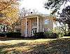 |
(#03000559) |
Roughly bounded by S. Robertson Av., Sunnybrook Dr., Fair Ln., Old Bullard Rd., College Av., W. 4th St., Highland Av.. 32°19′40″N 95°18′06″W / 32.327778°N 95.301667°W |
Tyler | |
| 2 | Blackstone Building |  |
(#02000645) |
315 N. Broadway 32°21′12″N 95°18′02″W / 32.35343°N 95.30045°W |
Tyler | |
| 3 | Brick Streets Neighborhood Historic District | Upload image | (#04000379) |
Roughly bounded by South Broadway, W. Dobbs St., S. Kennedy Ave., S. Vine Ave., Interior Property Lines, S. College Ave. 32°20′33″N 95°18′16″W / 32.3425°N 95.304444°W |
Tyler | |
| 4 | Carnegie Public Library | 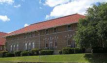 |
(#79003007) |
125 S. College St. 32°21′00″N 95°18′07″W / 32.35°N 95.301944°W |
Tyler | |
| 5 | Charnwood Residential Historic District | Upload image | (#99001023) |
Roughly bounded by E Houston, RR tracks, E Wells, S Donnybrook, E Dobbs, and S Broadway 32°20′28″N 95°17′50″W / 32.341111°N 95.297222°W |
Tyler | |
| 6 | Cotton Belt Building | 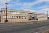 |
(#05001405) |
1517 W. Front St. 32°20′49″N 95°19′03″W / 32.34686°N 95.31762°W |
Tyler | |
| 7 | Crescent Laundry |  |
(#02000644) |
312-320 E. Ferguson St. 32°21′07″N 95°17′51″W / 32.35189°N 95.29761°W |
Tyler | |
| 8 | Col. John Dewberry House | 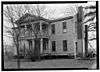 |
(#71000963) |
1 mi (1.6 km). N of Teaselville on FM 346 32°09′32″N 95°24′17″W / 32.15898°N 95.40460°W |
Teaselville | |
| 9 | Donnybrook Duplex Residential Historic District | Upload image | (#02000649) |
Roughly bounded by E. 6th St., Donnybrook Ave., E. 8th St., and S. Wall 32°19′42″N 95°17′48″W / 32.328333°N 95.296667°W |
Tyler | |
| 10 | John B. and Ketura (Kettie) Douglas House | 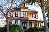 |
(#96001565) |
318 S. Fannin Ave. 32°20′51″N 95°17′54″W / 32.34742°N 95.29825°W |
Tyler | |
| 11 | East Ferguson Residential Historic District | 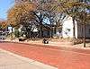 |
(#02000647) |
423-513 E. Ferguson St. 32°21′04″N 95°17′45″W / 32.351111°N 95.295833°W |
Tyler | |
| 12 | Elks Club Building | 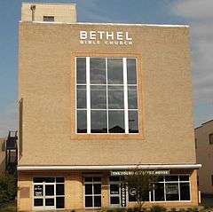 |
(#02000648) |
202 S. Broadway 32°20′58″N 95°18′01″W / 32.34941°N 95.30039°W |
Tyler | |
| 13 | D.R. Glass Library at Texas College | Upload image | (#07000128) |
2404 N. Grand Ave. 32°22′25″N 95°18′44″W / 32.373611°N 95.312222°W |
Tyler | |
| 14 | Goodman-LeGrand House | 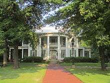 |
(#76002066) |
624 N. Broadway 32°21′24″N 95°18′05″W / 32.356667°N 95.301389°W |
Tyler | |
| 15 | Jenkins-Harvey Super Service Station and Garage | 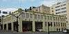 |
(#02000646) |
124 S. College 32°20′59″N 95°18′06″W / 32.34978°N 95.30158°W |
Tyler | |
| 16 | Martin Hall at Texas College | Upload image | (#05001404) |
2404 N. Grand Ave. 32°22′33″N 95°18′42″W / 32.375833°N 95.311667°W |
Tyler | |
| 17 | Marvin Methodist Episcopal Church, South | 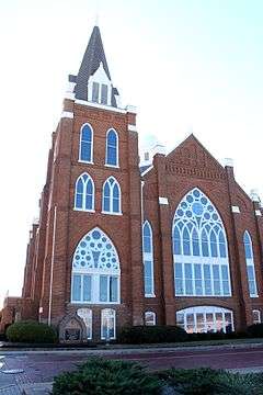 |
(#00001385) |
300 W. Erwin St. 32°21′01″N 95°18′11″W / 32.350278°N 95.303056°W |
Tyler | |
| 18 | Moore Grocery Co. Building | 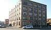 |
(#02000991) |
408 N. Broadway 32°21′14″N 95°18′03″W / 32.35392°N 95.30082°W |
Tyler | |
| 19 | People's National Bank Building | 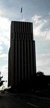 |
(#02000896) |
102 N. College Ave. 32°21′03″N 95°18′06″W / 32.350833°N 95.301667°W |
Tyler | |
| 20 | President's House at Texas College | Upload image | (#07000131) |
2404 N. Grand Ave. 32°22′27″N 95°18′40″W / 32.374167°N 95.311111°W |
Tyler | |
| 21 | Ramey House | 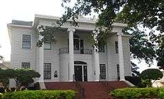 |
(#82001738) |
605 S. Broadway 32°20′37″N 95°18′04″W / 32.343566°N 95.30108°W |
Tyler | |
| 22 | Short-Line Residential Historic District | 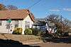 |
(#02000897) |
Roughly bounded by West Ln., N. Ellis, Short St., and an unnamed alley to the east 32°21′14″N 95°18′26″W / 32.353889°N 95.307222°W |
Tyler | |
| 23 | Smith County Jail, 1881 | 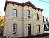 |
(#96000937) |
309 Erwin St. 32°21′02″N 95°17′53″W / 32.350587°N 95.297999°W |
Tyler | |
| 24 | St. James Colored Methodist Episcopal Church | 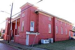 |
(#04000887) |
408 N. Border Ave. 32°21′15″N 95°18′23″W / 32.35404°N 95.30640°W |
Tyler | |
| 25 | St. John's AF & AM Lodge | 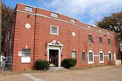 |
(#05001403) |
323 W. Front St. 32°20′50″N 95°18′14″W / 32.34726°N 95.30387°W |
Tyler | |
| 26 | St. Louis Southwestern Railway (Cotton Belt) Passenger Depot | 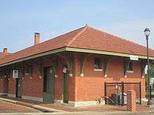 |
(#01000873) |
100 blk. E. Oakwood St., at N. Spring St. 32°21′17″N 95°17′56″W / 32.35478°N 95.29891°W |
Tyler | |
| 27 | Tyler City Hall | 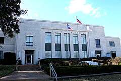 |
(#07000129) |
212 N. Bonner Ave. 32°21′07″N 95°18′21″W / 32.351944°N 95.305833°W |
Tyler | |
| 28 | Tyler Grocery Company |  |
(#02000993) |
416 N. Broadway 32°21′15″N 95°18′04″W / 32.354167°N 95.301111°W |
Tyler | |
| 29 | Tyler Hydraulic-Fill Dam | Upload image | (#77001543) |
W of Tyler off TX 31 32°19′52″N 95°22′07″W / 32.331111°N 95.368611°W |
Tyler | |
| 30 | Tyler US Post Office and Courthouse | 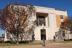 |
(#01000433) |
211 W. Ferguson St. 32°21′07″N 95°18′09″W / 32.35191°N 95.30254°W |
Tyler | |
| 31 | Whitaker-McClendon House |  |
(#82004522) |
806 W. Houston St. 32°20′36″N 95°18′34″W / 32.34334°N 95.30936°W |
Tyler | |
| 32 | Williams-Anderson House |  |
(#02000995) |
1313 W. Claude St. 32°21′09″N 95°18′54″W / 32.35259°N 95.31511°W |
Tyler |
See also
| Wikimedia Commons has media related to National Register of Historic Places in Smith County, Texas. |
References
- ↑ The latitude and longitude information provided in this table was derived originally from the National Register Information System, which has been found to be fairly accurate for about 99% of listings. For about 1% of NRIS original coordinates, experience has shown that one or both coordinates are typos or otherwise extremely far off; some corrections may have been made. A more subtle problem causes many locations to be off by up to 150 yards, depending on location in the country: most NRIS coordinates were derived from tracing out latitude and longitudes off of USGS topographical quadrant maps created under the North American Datum of 1927, which differs from the current, highly accurate WGS84 GPS system used by most on-line maps. Chicago is about right, but NRIS longitudes in Washington are higher by about 4.5 seconds, and are lower by about 2.0 seconds in Maine. Latitudes differ by about 1.0 second in Florida. Some locations in this table may have been corrected to current GPS standards.
- ↑ "National Register of Historic Places: Weekly List Actions". National Park Service, United States Department of the Interior. Retrieved on December 2, 2016.
- ↑ Numbers represent an ordering by significant words. Various colorings, defined here, differentiate National Historic Landmarks and historic districts from other NRHP buildings, structures, sites or objects.
- ↑ The eight-digit number below each date is the number assigned to each location in the National Register Information System database, which can be viewed by clicking the number.
| Topics | |
|---|---|
| Lists by states |
|
| Lists by insular areas | |
| Lists by associated states | |
| Other areas | |
| |
This article is issued from Wikipedia - version of the 12/2/2016. The text is available under the Creative Commons Attribution/Share Alike but additional terms may apply for the media files.