| [3] |
Name on the Register[4] |
Image |
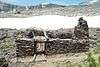
Date listed[5] |
Location |
City or town |
Description |
|---|
| 1 |
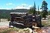
Baker Highway Maintenance Station |
Upload image |
000000002004-09-02-0000September 2, 2004
(#04000928) |
33950 CA 108
38°19′49″N 119°45′20″W / 38.330278°N 119.755556°W / 38.330278; -119.755556 (Baker Highway Maintenance Station) |
Strawberry |
|
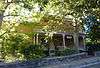
| 2 |
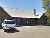
Cady House |
|
000000001982-02-25-0000February 25, 1982
(#82002281) |
72 N. Norlin St.
37°59′09″N 120°23′05″W / 37.985833°N 120.384722°W / 37.985833; -120.384722 (Cady House) |
Sonora |
|
| 3 |
Chinaman Mortar Site |
Upload image |
000000001975-06-20-0000June 20, 1975
(#75000492) |
Address Restricted
|
Strawberry |
|
| 4 |
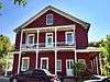
City Hotel |
|
000000001983-06-30-0000June 30, 1983
(#83001248) |
145 S. Washington St.
37°59′01″N 120°22′51″W / 37.983611°N 120.380833°W / 37.983611; -120.380833 (City Hotel) |
Sonora |
|
| 5 |
Columbia Historic District |
|
000000001966-10-15-0000October 15, 1966
(#66000242) |
4 mi (6.4 km). northwest of Sonora on CA 49
Coordinates missing |
Sonora |
|
| 6 |
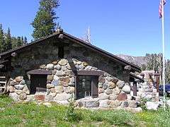
Cooper Cabin |
Upload image |
000000002009-01-09-0000January 9, 2009
(#08001314) |
Address Restricted, Emigrant Wilderness, Stanislaus National Forest
|
Strawberry |
|
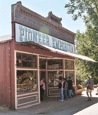
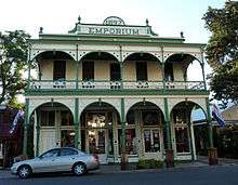
| 7 |
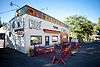
Emporium |
|
000000001978-02-17-0000February 17, 1978
(#78000817) |
735 Main St.
37°57′10″N 120°25′22″W / 37.952778°N 120.422778°W / 37.952778; -120.422778 (Emporium) |
Jamestown |
|
| 8 |
Frog Creek Cabin |
Upload image |
000000002014-07-18-0000July 18, 2014
(#14000414) |
South shore Lake Eleanor, along Frog Creek
37°58′59″N 119°50′37″W / 37.983126°N 119.843492°W / 37.983126; -119.843492 (Frog Creek Cabin) |
Yosemite |
|
| 9 |
Gamble Building and Miner's Bean Kettle |
|
000000001991-03-22-0000March 22, 1991
(#91000335) |
17544 CA 120
37°49′25″N 120°15′25″W / 37.823611°N 120.256944°W / 37.823611; -120.256944 (Gamble Building and Miner's Bean Kettle) |
Big Oak Flat |
|
| 10 |
Glen Aulin High Sierra Camp |
Upload image |
000000002014-07-18-0000July 18, 2014
(#14000415) |
At confluence of Tuolumne River and Alkali Creek
37°54′32″N 119°25′08″W / 37.908812°N 119.418772°W / 37.908812; -119.418772 (Glen Aulin High Sierra Camp) |
Yosemite |
|
| 11 |
Great Sierra Mine Historic Site |
|
000000001978-05-24-0000May 24, 1978
(#78000382) |
W of Lee Vining in Yosemite National Park
37°55′39″N 119°16′05″W / 37.9275°N 119.268056°W / 37.9275; -119.268056 (Great Sierra Mine Historic Site) |
Lee Vining |
|
| 12 |
Great Sierra Wagon Road |
Upload image |
000000001978-08-25-0000August 25, 1978
(#78000373) |
N of Yosemite Village
37°50′32″N 119°43′20″W / 37.842222°N 119.722222°W / 37.842222; -119.722222 (Great Sierra Wagon Road) |
Yosemite Valley |
|
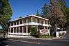
| 13 |
Groveland Hotel |
|
000000001994-05-06-0000May 6, 1994
(#94000428) |
18767 Main St. (CA 120)
37°50′22″N 120°13′42″W / 37.839444°N 120.228333°W / 37.839444; -120.228333 (Groveland Hotel) |
Groveland |
|
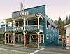
| 14 |
Hotel Charlotte |
|
000000001994-09-26-0000September 26, 1994
(#94001162) |
18736 Main St. (CA 120)
37°50′21″N 120°13′45″W / 37.839167°N 120.229167°W / 37.839167; -120.229167 (Hotel Charlotte) |
Groveland |
|
| 15 |
Lake Vernon Snow Survey Shelter |
Upload image |
000000002014-07-18-0000July 18, 2014
(#14000416) |
Terminus of Lake Vernon Tr.
38°01′10″N 119°42′55″W / 38.019422°N 119.715244°W / 38.019422; -119.715244 (Lake Vernon Snow Survey Shelter) |
Yosemite |
|
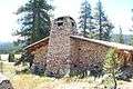
| 16 |
Leighton Encampment |
Upload image |
000000002013-04-09-0000April 9, 2013
(#13000142) |
Roughly 12 mi. SW. of Pinecrest
38°07′33″N 119°46′47″W / 38.125885°N 119.77972°W / 38.125885; -119.77972 (Leighton Encampment) |
Pinecrest |
Also known as Yellowhammer Camp
|
| 17 |
May Lake High Sierra Camp |
Upload image |
000000002014-07-18-0000July 18, 2014
(#14000417) |
Eastern shore of May Lake
37°50′42″N 119°29′28″W / 37.844924°N 119.490996°W / 37.844924; -119.490996 (May Lake High Sierra Camp) |
Yosemite |
|
| 18 |
McCauley Cabin |
|
000000001977-03-08-0000March 8, 1977
(#77000359) |
W of Lee Vining at Tuolumne Meadows
37°52′40″N 119°22′01″W / 37.877778°N 119.366944°W / 37.877778; -119.366944 (McCauley Cabin) |
Lee Vining |
|
| 19 |
Niagara Camp |
Upload image |
000000001975-06-06-0000June 6, 1975
(#75000494) |
NE of Tuolumne in Stanislaus National Forest
38°00′19″N 120°00′09″W / 38.005278°N 120.0025°W / 38.005278; -120.0025 (Niagara Camp) |
Tuolumne |
|
| 20 |
Parsons Memorial Lodge |
|
000000001979-04-30-0000April 30, 1979
(#79000283) |
Tuolumne Meadows
37°52′42″N 119°22′00″W / 37.878333°N 119.366667°W / 37.878333; -119.366667 (Parsons Memorial Lodge) |
Yosemite National Park |
|
| 21 |
Quail Site |
Upload image |
000000001975-03-10-0000March 10, 1975
(#75000491) |
Address Restricted
|
Long Barn |
|
| 22 |
Sachse Spring Snow Survey Shelter |
Upload image |
000000002014-07-18-0000July 18, 2014
(#14000418) |
Off of Kibbie Ridge Tr. near Sachse Spring
38°04′51″N 119°50′34″W / 38.080825°N 119.842905°W / 38.080825; -119.842905 (Sachse Spring Snow Survey Shelter) |
Yosemite |
|
| 23 |
Soda Springs Cabin |
|
000000001979-04-19-0000April 19, 1979
(#79000282) |
SW of Lee Vining
37°52′44″N 119°21′56″W / 37.878889°N 119.365556°W / 37.878889; -119.365556 (Soda Springs Cabin) |
Lee Vining |
|
| 24 |
Sonora Youth Center |
|
000000002009-10-08-0000October 8, 2009
(#09000807) |
732 S. Barretta St.
37°58′31″N 120°22′37″W / 37.975394°N 120.377003°W / 37.975394; -120.377003 (Sonora Youth Center) |
Sonora |
|
| 25 |
Sugg House |
|
000000001984-09-13-0000September 13, 1984
(#84001210) |
37 Theall St.
37°59′02″N 120°22′49″W / 37.983889°N 120.380278°W / 37.983889; -120.380278 (Sugg House) |
Sonora |
|
| 26 |
Stanislaus Branch, California Forest and Range Experiment Station |
Upload image |
000000002009-01-15-0000January 15, 2009
(#08001315) |
Forest Rd. 4N13B
Coordinates missing |
Strawberry |
|
| 27 |
Tioga Pass Entrance Station |
|
000000001978-12-14-0000December 14, 1978
(#78000372) |
SW of Lee Vining in Yosemite National Park
37°54′39″N 119°15′27″W / 37.910833°N 119.2575°W / 37.910833; -119.2575 (Tioga Pass Entrance Station) |
Lee Vining |
|
| 28 |
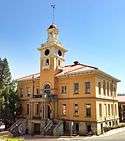
Tuolumne County Courthouse |
|
000000001981-09-17-0000September 17, 1981
(#81000182) |
41 W. Yaney Ave.
37°59′08″N 120°22′59″W / 37.985556°N 120.383056°W / 37.985556; -120.383056 (Tuolumne County Courthouse) |
Sonora |
|
| 29 |
Tuolumne County Jail |
|
000000001978-11-07-0000November 7, 1978
(#78000822) |
156 W. Bradford St.
37°59′02″N 120°23′04″W / 37.983889°N 120.384444°W / 37.983889; -120.384444 (Tuolumne County Jail) |
Sonora |
|
| 30 |
Tuolumne Meadows |
|
000000001978-11-30-0000November 30, 1978
(#78000371) |
SW of Lee Vining in Yosemite National Park
37°52′17″N 119°22′20″W / 37.871389°N 119.372222°W / 37.871389; -119.372222 (Tuolumne Meadows) |
Lee Vining |
|
| 31 |
Tuolumne Meadows High Sierra Camp |
Upload image |
000000002014-07-18-0000July 18, 2014
(#14000419) |
Along north banks of Dana Fork of Tuolumne River, east of Tuolumne Meadows
37°52′39″N 119°19′58″W / 37.877426°N 119.332655°W / 37.877426; -119.332655 (Tuolumne Meadows High Sierra Camp) |
Yosemite |
|
| 32 |
Tuolumne Meadows Ranger Stations and Comfort Stations |
|
000000001978-12-18-0000December 18, 1978
(#78000370) |
SW of Lee Vining in Yosemite National Park
37°52′24″N 119°21′16″W / 37.873333°N 119.354444°W / 37.873333; -119.354444 (Tuolumne Meadows Ranger Stations and Comfort Stations) |
Lee Vining |
|
| 33 |
Watts & Tannahill Company Store |
|
000000001995-03-31-0000March 31, 1995
(#95000265) |
18761 Main St. (CA 120)
37°50′21″N 120°13′43″W / 37.839167°N 120.228611°W / 37.839167; -120.228611 (Watts & Tannahill Company Store) |
Groveland |
|
| 34 |
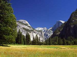
Yosemite Valley |
|
000000002006-12-14-0000December 14, 2006
(#04001159) |
Yosemite National Park
37°43′43″N 119°36′07″W / 37.728611°N 119.601944°W / 37.728611; -119.601944 (Yosemite Valley) |
Yosemite |
|