National Register of Historic Places listings in Washington Parish, Louisiana
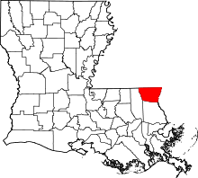
Location of Washington Parish in Louisiana
This is a list of the National Register of Historic Places listings in Washington Parish, Louisiana.
This is intended to be a complete list of the properties on the National Register of Historic Places in Washington Parish, Louisiana, United States. The locations of National Register properties for which the latitude and longitude coordinates are included below, may be seen in a map.[1]
There are 17 properties listed on the National Register in the parish.
- This National Park Service list is complete through NPS recent listings posted December 16, 2016.[2]
Current listings
| [3] |
Name on the Register[4] |
Image |
Date listed[5] |
Location |
City or town |
Description |
|---|
| 1 |
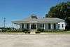
Robert H. Babington House |
Upload image |
000000001979-12-06-0000December 6, 1979
(#79001097) |
608 Main St.
30°50′55″N 90°09′27″W / 30.848611°N 90.1575°W / 30.848611; -90.1575 (Robert H. Babington House) |
Franklinton |
|
| 2 |
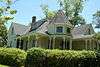
Thomas M. Babington House |
|
000000001995-07-21-0000July 21, 1995
(#95000899) |
828 Main St.
30°50′45″N 90°09′28″W / 30.845833°N 90.157778°W / 30.845833; -90.157778 (Thomas M. Babington House) |
Franklinton |
|
| 3 |
Bogalusa City Hall |
Upload image |
000000001979-07-26-0000July 26, 1979
(#79001095) |
214 Arkans Hall Ave.
30°47′09″N 89°51′36″W / 30.785833°N 89.86°W / 30.785833; -89.86 (Bogalusa City Hall) |
Bogalusa |
|
| 4 |
Bogalusa Railroad Station |
Upload image |
000000001980-05-01-0000May 1, 1980
(#80001767) |
400 Austin St.
30°47′24″N 89°51′38″W / 30.79°N 89.860556°W / 30.79; -89.860556 (Bogalusa Railroad Station) |
Bogalusa |
|
| 5 |
Brumfield Homestead |
Upload image |
000000002014-09-24-0000September 24, 2014
(#14000693) |
47082 T.C. Brumfield Rd.
30°54′35″N 90°06′33″W / 30.9097°N 90.1092°W / 30.9097; -90.1092 (Brumfield Homestead) |
Franklinton |
|
| 6 |
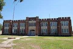
Franklinton High School |
|
000000001998-08-06-0000August 6, 1998
(#98000988) |
617 Main St.
30°50′58″N 90°09′29″W / 30.849444°N 90.158056°W / 30.849444; -90.158056 (Franklinton High School) |
Franklinton |
|
| 7 |
Greenlaw House |
|
000000001998-08-06-0000August 6, 1998
(#98000987) |
613 10th Ave.
30°51′00″N 90°09′26″W / 30.85°N 90.157222°W / 30.85; -90.157222 (Greenlaw House) |
Franklinton |
|
| 8 |
Robert "Bob" Hicks House |
Upload image |
000000002015-01-20-0000January 20, 2015
(#14001174) |
924 E. Robert "Bob" Hicks (formerly 9th) St.
30°46′15″N 89°50′48″W / 30.7708°N 89.8468°W / 30.7708; -89.8468 (Robert "Bob" Hicks House) |
Bogalusa |
Home of a prominent local Civil Rights leader of the 1960s.
|
| 9 |
Knight Cabin |
Upload image |
000000001979-01-23-0000January 23, 1979
(#79001098) |
Washington Parish Fairgrounds
30°51′18″N 90°09′59″W / 30.855°N 90.166389°W / 30.855; -90.166389 (Knight Cabin) |
Franklinton |
|
| 10 |
Nehemiah Magee House |
Upload image |
000000001982-08-12-0000August 12, 1982
(#82002802) |
Southwest of Mt. Hermon
30°56′35″N 90°19′53″W / 30.943056°N 90.331389°W / 30.943056; -90.331389 (Nehemiah Magee House) |
Mount Hermon |
|
| 11 |
Robert D. Magee House |
Upload image |
000000001982-08-11-0000August 11, 1982
(#82002801) |
West of Angie off Louisiana Highway 438
30°59′02″N 89°55′59″W / 30.983889°N 89.933056°W / 30.983889; -89.933056 (Robert D. Magee House) |
Angie |
|
| 12 |
Bouey Moore Homestead |
Upload image |
000000002009-12-08-0000December 8, 2009
(#09001059) |
19068 Moore Rd.
30°47′48″N 89°59′32″W / 30.796642°N 89.992322°W / 30.796642; -89.992322 (Bouey Moore Homestead) |
Franklinton |
|
| 13 |
Sullivan House |
Upload image |
000000001979-07-27-0000July 27, 1979
(#79001096) |
223 S. Border Dr.
30°46′48″N 89°52′08″W / 30.78°N 89.868889°W / 30.78; -89.868889 (Sullivan House) |
Bogalusa |
|
| 14 |
Sylvest House |
|
000000001979-01-23-0000January 23, 1979
(#79001099) |
Washington Parish Fairgrounds
30°51′18″N 90°09′58″W / 30.855°N 90.166111°W / 30.855; -90.166111 (Sylvest House) |
Franklinton |
|
| 15 |
US Post Office |
Upload image |
000000001983-01-27-0000January 27, 1983
(#83000552) |
305 Avenue B
30°46′43″N 89°52′00″W / 30.778611°N 89.866667°W / 30.778611; -89.866667 (US Post Office) |
Bogalusa |
|
| 16 |
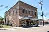
D.A. Varnado and Son Store |
|
000000002001-07-25-0000July 25, 2001
(#01000763) |
936 Pearl St.
30°50′38″N 90°09′15″W / 30.843889°N 90.154167°W / 30.843889; -90.154167 (D.A. Varnado and Son Store) |
Franklinton |
|
| 17 |
Warren House |
Upload image |
000000001998-12-04-0000December 4, 1998
(#98001442) |
29296 Louisiana Highway 25, N.
30°57′02″N 90°10′39″W / 30.950556°N 90.1775°W / 30.950556; -90.1775 (Warren House) |
Franklinton |
|
See also
References
- ↑ The latitude and longitude information provided in this table was derived originally from the National Register Information System, which has been found to be fairly accurate for about 99% of listings. For about 1% of NRIS original coordinates, experience has shown that one or both coordinates are typos or otherwise extremely far off; some corrections may have been made. A more subtle problem causes many locations to be off by up to 150 yards, depending on location in the country: most NRIS coordinates were derived from tracing out latitude and longitudes off of USGS topographical quadrant maps created under the North American Datum of 1927, which differs from the current, highly accurate WGS84 GPS system used by most on-line maps. Chicago is about right, but NRIS longitudes in Washington are higher by about 4.5 seconds, and are lower by about 2.0 seconds in Maine. Latitudes differ by about 1.0 second in Florida. Some locations in this table may have been corrected to current GPS standards.
- ↑ "National Register of Historic Places: Weekly List Actions". National Park Service, United States Department of the Interior. Retrieved on December 16, 2016.
- ↑ Numbers represent an ordering by significant words. Various colorings, defined here, differentiate National Historic Landmarks and historic districts from other NRHP buildings, structures, sites or objects.
- ↑ National Park Service (2009-03-13). "National Register Information System". National Register of Historic Places. National Park Service.
- ↑ The eight-digit number below each date is the number assigned to each location in the National Register Information System database, which can be viewed by clicking the number.
|
|---|
|
| Topics | |
|---|
|
| Lists by states | |
|---|
|
| Lists by insular areas | |
|---|
|
| Lists by associated states | |
|---|
|
| Other areas | |
|---|
|
-
 Portal Portal
-
 WikiProject WikiProject
|