Newcastle East, New South Wales
| Newcastle East Newcastle, New South Wales | |||||||||||||
|---|---|---|---|---|---|---|---|---|---|---|---|---|---|
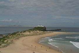 Nobbys Head shown from Fort ScratchleyNote1 | |||||||||||||
| Coordinates | 32°55′45″S 151°47′15.5″E / 32.92917°S 151.787639°ECoordinates: 32°55′45″S 151°47′15.5″E / 32.92917°S 151.787639°E | ||||||||||||
| Population | 975 (2006 census)[1] | ||||||||||||
| • Density | 8,552/km2 (22,150/sq mi) Note2 | ||||||||||||
| Postcode(s) | 2300 | ||||||||||||
| Area | 0.4 km2 (0.2 sq mi)Note3 | ||||||||||||
| Location | 0 km (0 mi) E of Newcastle | ||||||||||||
| LGA(s) | City of Newcastle | ||||||||||||
| Region | Hunter | ||||||||||||
| County | Northumberland | ||||||||||||
| Parish | Newcastle | ||||||||||||
| State electorate(s) | Newcastle | ||||||||||||
| Federal Division(s) | Newcastle | ||||||||||||
| |||||||||||||
Newcastle East is an inner city suburb of Newcastle, New South Wales, Australia, located immediately east of Newcastle's central business district at the mouth of the Hunter River.[2] The suburb includes Fort Scratchley, Newcastle Ocean Baths and Newcastle Beach.[3] Formerly a site of heavy industry and railway yards, the suburb now contains the large Foreshore Park, and historic terraced housing.
Beaches

Newcastle East is home to two of Newcastle's beaches, Nobbys Beach and Newcastle Beach, both of which have surf lifesaving clubs and are patrolled by lifesavers. In June 2007, the bulk carrier MV Pasha Bulker grounded itself off Nobbys Beach in a storm. Between Newcastle and Nobbys beaches lie the Newcastle Ocean Baths.
Fort Scratchley
Fort Scratchley is a fort atop a knoll overlooking Nobbys Beach. It was designed by Lt. Col. Peter Scratchley and built between 1881 and 1886. While its original purpose was to protect the colony against a feared Russian invasion, its most prominent role came during World War II when the guns at the fort fired upon a Japanese submarine which shelled the city in 1942. The military role of the fort came to an end in 1972 and it now houses the Newcastle Region Maritime and Military Museum.[4] Damage from the Japanese Navy attack during World War II can still be seen on the front of some of the buildings in East End. Today Fort Scratchley is a great place to visit when in Newcastle, with sweeping views of the city and coastline and helpful volunteers to guide you through the displays of military artefacts and take you back in time as you tour the tunnels. Fort Scratchley also has a library of military books kindly donated that members of the Fort Scratchley Historical Society can borrow for research.
Notes
- ^ Although Nobbys Head is arguably the best known landmark in Newcastle East, technically it isn't in the suburb.[2]
- ^ The density figure presented represents the density in the populated section of the suburb. (see Note 3)
- ^ Most of the suburb (approximately 72%) is occupied by coastal roads and beaches, Foreshore Park and the Fort Scratchley maritime and military museum. Only 28% of the suburb is continuously populated.
References
- ↑ Australian Bureau of Statistics (25 October 2007). "Newcastle East (State Suburb)". 2006 Census QuickStats. Retrieved 2008-01-27.
- 1 2 "Newcastle East". Land and Property Management Authority - Spatial Information eXchange. New South Wales Land and Property Information. Retrieved 2008-05-14.
- ↑ "Newcastle East Heritage Walk". Visit Newcastle.com.au. Retrieved 2008-01-27.
- ↑ "Newcastle". The Sydney Morning Herald. 2004-02-08. Retrieved 2008-01-27.