North Palm Beach, Florida
| North Palm Beach, Florida | |
|---|---|
| Village | |
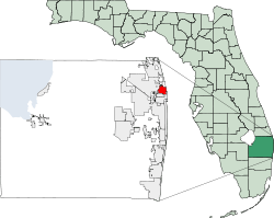
 Location of North Palm Beach in Palm Beach County, Florida | |
| Coordinates: 26°49′6″N 80°3′49″W / 26.81833°N 80.06361°WCoordinates: 26°49′6″N 80°3′49″W / 26.81833°N 80.06361°W | |
| Country |
|
| State |
|
| County | Palm Beach |
| Government | |
| • Type | Council-Manager |
| • Village Council |
Mayor David Norris Vice Mayor Doug Bush President Pro-tem Darryl Aubrey Councilman Robert Gebbia Councilman Mark Mullinax |
| • Village Manager | James Kelly |
| Area | |
| • Total | 5.8 sq mi (15.0 km2) |
| • Land | 3.6 sq mi (9.2 km2) |
| • Water | 2.2 sq mi (5.8 km2) |
| Elevation | 10 ft (3 m) |
| Population (2010) | |
| • Total | 12,015 |
| • Density | 3,337.50/sq mi (1,305.98/km2) |
| Time zone | Eastern (EST) (UTC-5) |
| • Summer (DST) | EDT (UTC-4) |
| ZIP codes | 33403, 33408, 33410 |
| Area code(s) | 561 |
| FIPS code | 12-49600[1] |
| GNIS feature ID | 0287845[2] |
| Website | Village of North Palm Beach |
North Palm Beach is an incorporated village in Palm Beach County, Florida, United States. The population was 12,015 at the 2010 census. The village won an award from the National Association of Home Builders as best planned community of 1956. The North Palm Beach Country Club is home to a Jack Nicklaus Signature golf course.
History
In 1954 for $5.5 million John D. MacArthur bought 2,600 acres (11 km2) of land in northern Palm Beach County that had been owned originally by Harry Seymour Kelsey and later by Sir Harry Oakes. The land included most of today's North Palm Beach as well as Lake Park, Palm Beach Gardens and Palm Beach Shores.[3] MacArthur then began developing what is now North Palm Beach, which sat on former mangrove swamps and farm land. The area was punctuated only by Monet Road and Johnson Dairy Road to the north and south and US 1 and Prosperity Farms Road to the east and west.
Full-scale development and incorporation as a village occurred nearly simultaneously in 1956, with extensive dredging creating waterfront cul-de-sacs, and the development of a new east-west artery, Lighthouse Drive, connecting Old Dixie Highway and the newly aligned US 1. US 1 was widened and became the main office and civic corridor. Sir Harry Oakes' castle-like home on US 1 became the clubhouse for the North Palm Beach Country Club, which is located on the village island surrounded by the Inter-coastal Waterway reached by three bridges Lighthouse Drive bridge to the West, the Earmon River bridge to the south, and the Parker drawbridge to the north.
In 1958-1959, North Palm Beach elected Walter E. Thomas, Jr. as its first Mayor. Walter and his wife Jackie and four children (Ted, Larry, Jim, and Pam) were the 55th family to move into the Village, arriving in 1957.
Lake Park West Road was also extended from Old Dixie Highway to US 1 and was renamed Northlake Boulevard, becoming the village's main commercial corridor. The Twin City Mall, an enclosed shopping center, opened in 1970 at the corner of Northlake Boulevard and US 1 as Palm Beach County's second enclosed shopping mall. This Mall built onto the previous grocery store/strip mall completed in 1959. The mall contained a Sears, Jeffersons and GC Murphy's department stores, as well as the locally popular Karmelcorn and Orange Bowl eateries. The mall also sported one of the few movie theaters in the vicinity. The enclosed mall was demolished in the mid-1990s and has gradually been replaced by a mid-sized strip mall anchored by Publix.
In 2006, village resident Jack Nicklaus redesigned the village's golf course and it reopened in late 2006.
Geography
North Palm Beach is located at 26°49′06″N 80°03′49″W / 26.818239°N 80.063714°W.[4]
According to the United States Census Bureau, the village has a total area of 5.8 square miles (15 km2), of which 3.6 square miles (9.3 km2) is land and 2.2 square miles (5.7 km2) (38.62%) is water.
Demographics
| Historical population | |||
|---|---|---|---|
| Census | Pop. | %± | |
| 1960 | 2,684 | — | |
| 1970 | 9,035 | 236.6% | |
| 1980 | 11,344 | 25.6% | |
| 1990 | 11,343 | 0.0% | |
| 2000 | 12,064 | 6.4% | |
| 2010 | 12,015 | −0.4% | |
| Est. 2015 | 12,853 | [5] | 7.0% |
As of the census[1] of 2010, there were 12,015 people, 6,093 households, and 3,174 families residing in the village. The population density was 3,337.5 inhabitants per square mile (1,305.98/km²). There were 7,710 housing units at an average density of 2,057.1 per square mile (794.4/km²). The racial makeup of the village was 94.6% White, 2.7% African American, 0.1% Native American, 1.7% Asian, 0.02% Pacific Islander, Hispanic or Latino of White race were 4.9%. 0.9% from other races, and 1.3% from two or more races.
There were 6,093 households out of which 15.3% had children under the age of 18 living with them, 42.1% were married couples living together, 6.9% had a female householder with no husband present, and 47.9% were non-families. 39.2% of all households were made up of individuals and 18.3% had someone living alone who was 65 years of age or older. The average household size was 1.97 and the average family size was 2.63.
In the village the population was spread out with 14.0% under the age of 18, 3.9% from 18 to 24, 24.2% from 25 to 44, 26.8% from 45 to 64, and 30.8% who were 65 years of age or older. The median age was 50.4 years. For every 100 females there were 94.7 males. For every 100 females age 18 and over, there were 92.1 males.
The median income for a household in the village was $60,738, and the median income for a family was $82,713. Males had a median income of $53,061 versus $34,024 for females. The per capita income for the village was $45,524. About 3.7% of families and 7.0% of the population were below the poverty line, including 7.3% of those under age 18 and 4.6% of those age 65 or over.
As of 2010, speakers of English as a first language accounted for 92.78% of all residents, while Spanish consisted of 3.91%, French was at 1.32%, German made up 0.92%, Italian 0.66%, and Greek was the mother tongue of 0.39% of the population.[7]
Points of interest
- John D. MacArthur Beach State Park is located nearby.
Notable people
- Jeff Atwater - Chief Financial Officer of Florida
- Gardner Dickinson - PGA golfer
- Mike Douglas - Famous American entertainer
- Ryan Klesko - Retired Major League Baseball first baseman
- Jack Nicklaus - Golf legend and course architect
- Elin Nordegren - Swedish former model and the ex-wife of golfer Tiger Woods[8]
- Sir Harry Oakes - early developer of the area
- Chris Cline - Mining billionaire - Regarded by Bloomberg as New King Coal,[9]
References
- 1 2 "American FactFinder". United States Census Bureau. Retrieved 2008-01-31.
- ↑ "US Board on Geographic Names". United States Geological Survey. 2007-10-25. Retrieved 2008-01-31.
- ↑ McGoun, William E., Southeast Florida Pioneers: The Palm and Treasure Coasts, 1998, Sarasota: Pineapple Press, p. 167
- ↑ "US Gazetteer files: 2010, 2000, and 1990". United States Census Bureau. 2011-02-12. Retrieved 2011-04-23.
- ↑ "Annual Estimates of the Resident Population for Incorporated Places: April 1, 2010 to July 1, 2015". Retrieved July 2, 2016.
- ↑ "Census of Population and Housing". Census.gov. Retrieved June 4, 2015.
- ↑ "MLA Data Center Results of North Palm Beach, FL". Modern Language Association. Retrieved 2007-11-13.
- ↑ http://virtualglobetrotting.com/map/elin-nordegrens-house-2/
- ↑ Lippert, John (October 12, 2010). "New King Coal". Bloomberg Markets Magazine. Bloomberg L.P. Retrieved June 23, 2011.
Chris Cline became a billionaire by betting on a dirty fuel the world can’t get enough of. With maps of 675 square miles of his Illinois mines before him, Chris Cline recalls the moment he knew the coal in those mines would be worth billions of dollars.
External links
- Village of North Palm Beach Official website

