Nuristan Province
| Nuristan نورستان | |
|---|---|
| Province | |
|
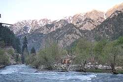
A river in Nuristan province | |
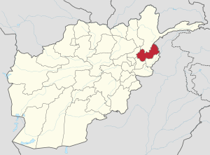 Map of Afghanistan with Nuristan highlighted | |
| Coordinates: 35°15′N 70°45′E / 35.25°N 70.75°ECoordinates: 35°15′N 70°45′E / 35.25°N 70.75°E | |
| Country |
|
| Provincial center | Parun |
| Government | |
| • Governor | Hafiz Abdul Qayyum |
| Area | |
| • Total | 9,225.0 km2 (3,561.8 sq mi) |
| Population [1] | |
| • Total | 140,900 |
| • Density | 15/km2 (40/sq mi) |
| Time zone | GMT+4:30 |
| ISO 3166 code | AF-NUR |
| Main languages | Nuristani |
Nuristan, also spelled Nurestan or Nooristan, (Nuristani/Pashto: نورستان) is one of the 34 provinces of Afghanistan, located in the eastern part of the country. It is divided into seven districts and has a population of about 140,900.[1] Parun serves as the provincial capital.
It was formerly known as Kafiristan (کافرستان, "land of the infidels") until the inhabitants were converted to Islam in 1895, and thence the region has become known as Nuristan ("land of light").[2]
The primary occupations are agriculture, animal husbandry, and day labor. Located on the southern slopes of the Hindu Kush mountains in the northeastern part of the country, Nuristan spans the basins of the Alingar, Pech, Landai Sin, and Kunar rivers. Nuristan is bordered on the south by Laghman and Kunar provinces, on the north by Badakhshan province, on the west by Panjshir province, and on the east by Khyber Pakhtunkhwa, Pakistan.
History
Early history
The surrounding area fell to Alexander the Great in 330 B.C. It later fell to Chandragupta Maurya. The Mauryas introduced Buddhism to the region, and were attempting to expand their empire to Central Asia until they faced local Greco-Bactrian forces. Seleucus is said to have reached a peace treaty with Chandragupta by giving control of the territory south of the Hindu Kush to the Mauryas upon intermarriage and 500 elephants.
Alexander took these away from the Indo-Aryans and established settlements of his own, but Seleucus Nicator gave them to Sandrocottus (Chandragupta), upon terms of intermarriage and of receiving in exchange 500 elephants.'[3]— Strabo, 64 BCE–24 CE
Some time after, as he was going to war with the generals of Alexander, a wild elephant of great bulk presented itself before him of its own accord, and, as if tamed down to gentleness, took him on its back, and became his guide in the war, and conspicuous in fields of battle. Sandrocottus, having thus acquired a throne, was in possession of India, when Seleucus was laying the foundations of his future greatness; who, after making a league with him, and settling his affairs in the east, proceeded to join in the war against Antigonus. As soon as the forces, therefore, of all the confederates were united, a battle was fought, in which Antigonus was slain, and his son Demetrius put to flight.[4]
Having consolidated power in the northwest, Chandragupta pushed east towards the Nanda Empire. Afghanistan's significant ancient tangible and intangible Buddhist heritage is recorded through wide-ranging archeological finds, including religious and artistic remnants. Buddhist doctrines are reported to have reached as far as Balkh even during the life of the Buddha (563 BCE to 483 BCE), as recorded by Xuanzang.
In this context a legend recorded by Xuanzang refers to the first two lay disciples of Buddha, Trapusa and Bhallika responsible for introducing Buddhism in that country. Originally these two were merchants of the kingdom of Balhika, as the name Bhalluka or Bhallika probably suggests the association of one with that country. They had gone to India for trade and had happened to be at Bodhgaya when the Buddha had just attained enlightenment.[5]
The region was historically known as Kafiristan (meaning "Land of the kafirs") because of its inhabitants: the Nuristani, an ethnically distinctive people who practiced a local polytheistic religion.[6] It was conquered by Emir Abdur Rahman Khan in the late 19th century and the Nuristani people began converting to Islam.
The Kafirs are thought to be the original inhabitants of the plains country of Afghanistan in what is now Nuristan. They were driven back into the mountain areas by the arrival of Islam in the country about 700AD. They are thought to be the descendents of the old native population that used to occupy the region, and they did not convert to Islam with the rest of the population, remaining pagan for several more centuries.[7]— Frank Clements, 2003
British missionaries wrote:
The Kafirs were largely independent until the late nineteenth century, when the region was attacked by the forces of Abdur Rahman and the population was more forcibly converted to Islam.[7]
The region was renamed Nuristan, meaning Land of the enlightened, a reflection of the "enlightening" of the pagan Nuristani by the "light-giving" of Islam.
Nuristan was once thought to have been a region through which Alexander the Great passed with a detachment of his army; thus the folk legend that the Nuristani people are descendants of Alexander (or "his generals").
Abdul Wakil Khan Nuristani is one of the most prominent figures in Nuristan's history. He fought against the British-led Punjabi army and drove them out of the eastern provinces of Afghanistan. He is buried on the same plateau where King Amanullah Khan is buried.
Recent history
Since the creation of Pakistan in 1947, Afghan politicians (particularly Mohammed Daoud Khan) have been focusing on re-annexing Khyber Pakhtunkhwa and the Federally Administered Tribal Areas of what is now Pakistan. This has led to militancy on both sides of the Durand Line.[8] In the meantime, Pakistani politicians have been focusing on connecting what is now Tajikistan with Pakistan. This requires weakening Afghan rule in Nuristan and Badakhshan provinces by secretly funding anti-Afghan rebel forces.
Nuristan was the scene of some of the heaviest guerrilla fightings during the 1980s Soviet war in Afghanistan. The province was influenced by Mawlawi Afzal's Islamic Revolutionary State of Afghanistan, which was supported by Pakistan nationalists and Saudi Arabia. It dissolved under the Islamic Emirate of Afghanistan (Taliban rule) in the late 1990s.[9]
Nuristan is one of the poorest and most remote provinces of Afghanistan. Few NGO's operate in Nuristan because of Taliban insurgency and lack of safe roads. The United States and the Afghan government are jointly working to solve these issues. Some road construction projects were launched linking Nangarej to Mandol and Chapa Dara to Titan Dara.[10] The Afghan government also worked on a direct road route to Laghman province, in order to reduce dependence on the road through restive Kunar province to the rest of Afghanistan. Other road projects were started aimed at improving the primitive road from Kamdesh to Barg-i Matal, and from Nangalam in Kunar province to the provincial center at Parun.
Since Nuristan is a highly ethnically homogeneous province, there are few incidents of inter-ethnic violence. However, there are instances of disputes among inhabitants, some of which continue for decades. Nuristan has suffered from its inaccessibility and lack of infrastructure. The government presence is under-developed, even compared to neighboring provinces. Nuristan's formal educational sector is weak, with few professional teachers. Due to its proximity to Pakistan, many of the inhabitants are actively involved in trade and commerce across the border.
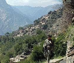
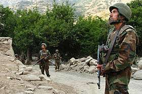
A map from the Afghan Ministry of the Interior produced in 2009 showed the western region of Nuristan to be under "enemy control". There have been numerous conflicts between anti-Afghanistan militants and U.S.-led Afghan security forces. In April 2008 members of the 3rd Special Forces Group led Afghan soldiers from the Commando Brigade into the Shok valley in an unsuccessful attempt to capture warlord Gulbuddin Hekmatyar. In July 2008 approximately 200 Taliban guerrillas attacked a NATO position just south of Nuristan, near the village of Wanat in the Waygal District, killing 9 U.S. soldiers.[11] In the following year, in early October, more than 350 anti-Afghanistan militants backed by members of the Hezb-e Islami Gulbuddin and other militia groups fought U.S.-led Afghan security forces in the Battle of Kamdesh at Camp Keating in Nuristan. The base was nearly overrun; more than 100 Taliban fighters, eight U.S. soldiers, and seven members of the Afghan security forces were killed during the fighting.[12][13][14][15] Four days after the battle, in early October 2009, U.S. forces withdrew from their four main bases in Nuristan, as part of a plan by General Stanley McChrystal to pull troops out of small outposts and relocate them closer to major towns.[16] The U.S. has pulled out from some areas in the past, but never from all four main bases.[17] A month after the U.S. pullout the Taliban was governing openly in Nuristan.[18] According to The Economist, Nuristan is "a place so tough that NATO abandoned it in 2010 after failing to subdue it."[19]
Politics and governance
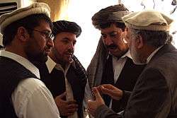
The current governor of the province is Hafiz Abdul Qayyum.[21] His predecessor was Jamaluddin Badar, who was sacked and convicted in Kabul for political corruption.[20] The town of Parun serves as the capital of Nuristan province.
All law enforcement activities throughout the province are controlled by the Afghan National Police (ANP). The border with neighboring Khyber Pakhtunkhwa is monitored by the Afghan Border Police (ABP). A provincial police chief is assigned to lead both the ANP and the ABP. The Police Chief represents the Ministry of the Interior in Kabul. The ANP and ABP are backed by the Afghan Armed Forces, including the NATO-led forces.
Healthcare
The percentage of households with clean drinking water increased from 2% in 2005 to 12% in 2011.[22] The percentage of births attended by a skilled birth attendant increased from 1% in 2005 to 22% in 2011.[22]
Education
In 2002 the first gender assessment of women's conditions in Nuristan was completed.[23] The overall literacy rate (6+ years of age) fell from 17.7% in 2005 to 17% in 2011.[22] The overall net enrolment rate (6–13 years of age) increased from 8.7% in 2005 to 45% in 2011.[22]
Demographics
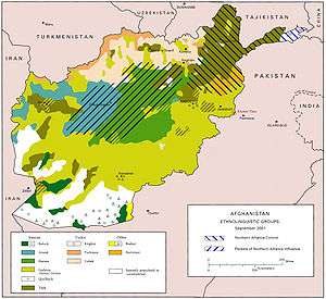
As of 2013, the total population of the province is about 140,900.[1] According to the Naval Postgraduate School, around 99.3% are Nuristanis and 0.6% Gujjars.[24][25]
Approximately 90% of the population speak the following Nuristani languages:[26]
The Pashayi languages is used by about 15% of the population.[26]
The main Nuristani tribes in the province are:
Pashto and Dari are used as second and third languages in the province.
Districts
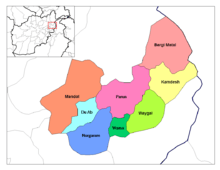
| District | Center | Population[1] | Area[27] | Notes |
|---|---|---|---|---|
| Barg-i Matal | 15,000 | |||
| Du Ab | 7,700 | Established in 2004, formerly part of Nuristan District and Mangol District | ||
| Kamdesh | Kamdesh | 24,500 | ||
| Mandol | 19,200 | Lost territory to Du Ab District in 2004 | ||
| Nurgram | 31,400 | Established in 2004, formerly part of Nuristan District and Wama District | ||
| Parun | Parun | 13,200 | Established in 2004, formerly part of Wama District | |
| Wama | 10,800 | Lost territory to Parun District and Nurgram District in 2004 | ||
| Waygal | 19,100 |
In popular culture
- Nuristan is the subject of the book A Short Walk in the Hindu Kush by the British travel writer Eric Newby.
- Nuristan was the location of three of the missions in Hitman 2: Silent Assassin.
- Rudyard Kipling's short story The Man Who Would Be King and the film inspired by it are set in pre-Islamic Nuristan.
Notable people from the province
See also
References
- 1 2 3 4 "Settled Population of Nooristan province by Civil Division, Urban, Rural and Sex-2012-13" (PDF). Islamic Republic of Afghanistan, Central Statistics Organization. Retrieved 2015-07-13.
- ↑ Klimberg, Max (October 1, 2004). "NURISTAN". Encyclopædia Iranica (Online ed.). United States: Columbia University.
- ↑ Nancy Hatch Dupree / Aḥmad ʻAlī Kuhzād (1972). "An Historical Guide to Kabul - The Name". American International School of Kabul. Retrieved 2010-09-18.
- ↑ Historiarum Philippicarum libri XLIV, XV.4.19
- ↑ Puri, Baij Nath (1987). Buddhism in central Asia. Motilal Banarsidass Publ. p. 352. ISBN 81-208-0372-8. Retrieved 2010-11-03.
- ↑ "Nangarhar Province". Understanding War. Retrieved 2014-10-21.
- 1 2 Conflict in Afghanistan: a historical encyclopedia by Frank Clements, Ludwig W. Adamec Edition: illustrated Published by ABC-CLIO, 2003 Page 139 ISBN 1-85109-402-4, ISBN 978-1-85109-402-8
- ↑ Bowersox, Gary W. (2004). The Gem Hunter: The Adventures of an American in Afghanistan. United States: GeoVision, Inc.,. p. 100. ISBN 0-9747-3231-1. Retrieved 2010-08-22.
To launch this plan, Bhutto recruited and trained a group of Afghans in the Bala-Hesar of Peshawar, in Pakistan's North-west Frontier Province. Among these young men were Massoud, Gulbuddin Hekmatyar, and other members of Jawanan-e Musulman. Massoud's mission to Bhutto was to create unrest in northern Afghanistan. It served Massoud's interests, which were apparently opposition to the Soviets and independence for Afghanistan. Later, after Massoud and Hekmatyar had a terrible falling-out over Massoud's opposition to terrorist tactics and methods, Massoud overthrew from Jawanan-e Musulman. He joined Rabani's newly created Afghan political party, Jamiat-i-Islami, in exile in Pakistan.
- ↑ Daan Van Der Schriek, ed. (May 26, 2005). "Nuristan: Insurgent Hideout in Afghanistan, Terrorism Monitor, Volume 3, Issue 10". Retrieved 2014-10-22.
- ↑ Nuristan governor, contractor, and Afghanistan engineer district sign partnership agreement at the Wayback Machine (archived July 8, 2007), Headquarters US Central Command, News Release, June 13, 2006
- ↑ "Taliban fighters storm US base". Al Jazeera. Retrieved 2008-07-16.
- ↑ Taliban govern openly in Nuristan, Bill Roggio, Long War Journal, 2009-11-12
- ↑ Taliban Claim to Seize American Arms, Robert Mackey, New York Times, 2009-11-12
- ↑ Eight U.S. Troops Die in Attack on Afghan Outpost, Joshua Partow, Washington Post, 2009-10-04
- ↑ Heavy US losses in Afghan battle, Martin Patience, BBC News, Kabul, 4 October 2009
- ↑ Kamdesh ambush played out like Wanat battle, Matthew Cox and Michelle Tan, Army Times, November 3, 2009
- ↑ "South Asia news, business and economy from India and Pakistan". Asia Times Online. 2009-10-29. Retrieved 2011-02-07.
- ↑ Taliban govern openly in Nuristan, Bill Roggio, Long War Journal, 2009-11-12
- ↑ "Pakistan's border badlands: Double games". The Economist. Jul 12, 2014. Retrieved 17 July 2014.
- 1 2 Zarghona Salehi, ed. (September 26, 2012). "Governor among 3 ex-Nuristan officials jailed". Pajhwok Afghan News. Retrieved 2014-10-22.
- ↑ Mahbob Shah Mahbob, ed. (April 22, 2014). "Nuristan's development completely neglected: Governor". Pajhwok Afghan News. Retrieved 2014-10-22.
- 1 2 3 4 Archive, Civil Military Fusion Centre
- ↑ "Wazhma Frogh". inclusivesecurity.org.
- ↑ "Nuristan Province" (PDF). Program for Culture & Conflict Studies. Naval Postgraduate School. Retrieved 2014-10-21.
- ↑ Nuristan Tribal Map on nps.edu
- 1 2 Nuristan provincial profile profile compiled by the National Area-Based Development Programme (NABDP) of the Ministry of Rural Rehabilitation and Development (MRRD)
- ↑ Afghanistan Geographic & Thematic Layers
Further reading
- Dupree, Nancy Hatch (1977): An Historical Guide to Afghanistan. 1st Edition: 1970. 2nd Edition. Revised and Enlarged. Afghan Tourist Organization. LINK
- Richard F. Strand. (1997–present) Richard Strand's Nuristan Site LINK. The most accurate and comprehensive source on Nuristan, by the world's leading scholar on the languages and ethnic groups of Nuristan.
- M. Klimburg. NURISTAN in Encyclopedia Iranica. LINK
- Edelberg, Lennart (1984) "Nuristani Buildings" Jutland Archaeological Society Publications, Vol. 18, 1984.
- Edelberg, Lennart & Schuyler Jones (1979) "Nuristan" Akademische Druck und Verlagsanstalt, Graz, Austria
- Jones, Schuyler (1992) "Afghanistan" Vol. 135 of the World Bibliographical Series, Clio Press, Oxford.
- Jones, Schuyler (1974) "Men of Influence in Nuristan: A Study of Social Control & Dispute Settlement in Waigal Valley, Afghanistan." Seminar Press, London & New York.
- Wilber, Donald N. (1968)Annotated Bibliography of Afghanistan. Human Relations Area Files, New Haven, Conn.
- Jones, Schuyler (1966) An Annotated Bibliography of Nuristan (Kafiristan) and the Kalash Kafirs of Chitral, Part One. Royal Danish Academy of Sciences & Letters, Vol. 41, No. 3.
- Kukhtina, Tatiyana I. (1965) Bibliografiya Afghanistana: Literatuyra na russkom yazyka. Nauka, Moscow.
- Akram, Mohammed (1947) Bibliographie de l'Afghanistan, I, ouvrages parus hors de l'Afghanistan. Centre de Documentation Universitaire, Paris.
- Robertson, Sir George S. (1900) The Kafirs of Hindu-Kush. LINK
External sources
| Wikimedia Commons has media related to Nuristan Province. |
| Wikivoyage has a travel guide for Nuristan. |
- Nuristan Province by the Naval Postgraduate School (NPS)
- Nuristan Province by the Institute for the Study of War (ISW)
 |
Badakhshan Province | |
| |
| Panjshir Province | |
|||
| ||||
| | ||||
| Laghman Province | Kunar Province |