Otaru
| Otaru 小樽市 | ||
|---|---|---|
| City | ||
|
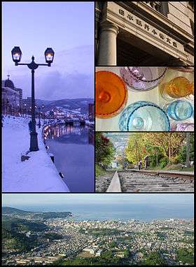
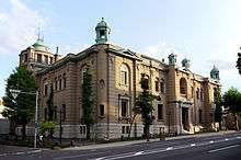
Top left: Otaru Canal Top right: The Bank of Japan Otaru Museum | ||
| ||
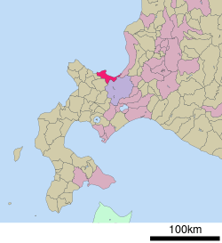 Location of Otaru in Hokkaido | ||
 Otaru
| ||
| Coordinates: 43°11′N 141°0′E / 43.183°N 141.000°ECoordinates: 43°11′N 141°0′E / 43.183°N 141.000°E | ||
| Country | Japan | |
| Region | Hokkaido | |
| Prefecture | Hokkaido (Shiribeshi Subprefecture) | |
| Government | ||
| • Mayor | Hideaki Morii (since May 2015) | |
| Area | ||
| • Total | 243.13 km2 (93.87 sq mi) | |
| Population (July 31, 2011) | ||
| • Total | 131,706 | |
| • Density | 541.71/km2 (1,403.0/sq mi) | |
| Time zone | Japan Standard Time (UTC+9) | |
| - Tree | Shirakaba (Siberian Silver Birch) | |
| - Flower | Azalea | |
| - Bird | Aobato (Japanese Green Pigeon) | |
| Phone number | 0134-32-4111 | |
| Address |
2-12-1 Hanazono, Otaru-shi, Hokkaido 047-8660 | |
| Website | City of Otaru | |

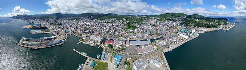
Otaru (小樽市 Otaru-shi) is a city and port in Shiribeshi Subprefecture, Hokkaido, Japan, northwest of Sapporo. The city faces the Ishikari Bay, and has long served as the main port of the bay. With its many historical buildings, Otaru is a popular tourist destination. Because it is a 25-minute drive from Sapporo, it has recently grown as a bedroom community.
As of 31 July, 2011, the city has an estimated population of 131,706 with 67,308 households and a population density of 541.71 persons per km² (1,403.0 persons per sq. mi.). The total area is 243.13 km2 (93.87 sq mi). Although it is the largest city in Shiribeshi Subprefecture, the subprefecture's capital is the more centrally located Kutchan.
Geography
Otaru is a port town on the coast of the Sea of Japan in northern Shiribeshi Subprefecture. The southern portion of the city is characterized by the steep slopes of various mountains, notably Tenguyama; and the altitude of the land sharply drops from the mountains to the sea. The land available between the coast and mountains has been almost completely developed, and the developed part of the city on the mountain slopes is called Saka-no-machi, or "Hill town", including hills named Funamizaka (Boat-view Hill) and Jigokuzaka (Hell Hill).
Neighboring cities and towns
Rivers
Some of the rivers in Otaru are: Hoshioki, Kiraichi, Zenibako, Hariusu, Asari, Katsunai, Shioya, Myoken, Irifune.
Climate
In the summer the weather, like all of western Hokkaido, is very warm and balmy, with a maximum temperature of around 25 °C (77 °F) and high humidity - not as hot as southern Japan. In the winter, however, Otaru is very snowy, receiving as much as 6.6 metres (260 in) of snow from November to March, when it snows almost constantly and sunshine levels are extremely low. The average maximum snow cover is 1.22 metres (48 in). Extreme temperatures have ranged from 34.9 °C (94.8 °F) on August 1, 2000 to −18.0 °C (−0.4 °F) on January 24, 1954, in which month the highest snowfall of 3.1 metres (122 in) occurred.[1] Monthly precipitation totals in a record dating back to 1943 have ranged from 379.8 millimetres (15.0 in) in August 1962 to 12.0 millimetres (0.5 in) in June 2007.[1]
| Climate data for Otaru (1981–2010) | |||||||||||||
|---|---|---|---|---|---|---|---|---|---|---|---|---|---|
| Month | Jan | Feb | Mar | Apr | May | Jun | Jul | Aug | Sep | Oct | Nov | Dec | Year |
| Average high °C (°F) | −0.7 (30.7) |
−0.1 (31.8) |
3.7 (38.7) |
10.8 (51.4) |
16.4 (61.5) |
20.1 (68.2) |
23.7 (74.7) |
25.6 (78.1) |
21.9 (71.4) |
15.7 (60.3) |
8.1 (46.6) |
1.7 (35.1) |
12.2 (54.0) |
| Daily mean °C (°F) | −3.3 (26.1) |
−2.9 (26.8) |
0.5 (32.9) |
6.5 (43.7) |
11.6 (52.9) |
15.7 (60.3) |
19.8 (67.6) |
21.7 (71.1) |
17.7 (63.9) |
11.5 (52.7) |
4.7 (40.5) |
−1 (30) |
8.54 (47.38) |
| Average low °C (°F) | −6.1 (21) |
−5.8 (21.6) |
−2.6 (27.3) |
2.6 (36.7) |
7.5 (45.5) |
12.1 (53.8) |
16.6 (61.9) |
18.4 (65.1) |
13.9 (57) |
7.6 (45.7) |
1.4 (34.5) |
−3.7 (25.3) |
5.2 (41.3) |
| Average precipitation mm (inches) | 142.3 (5.602) |
105.6 (4.157) |
86.2 (3.394) |
57.4 (2.26) |
56.1 (2.209) |
46.3 (1.823) |
79.3 (3.122) |
117.7 (4.634) |
125.6 (4.945) |
130.3 (5.13) |
146.8 (5.78) |
141.4 (5.567) |
1,235 (48.623) |
| Average snowfall cm (inches) | 194 (76.4) |
156 (61.4) |
107 (42.1) |
15 (5.9) |
0 (0) |
0 (0) |
0 (0) |
0 (0) |
0 (0) |
1 (0.4) |
45 (17.7) |
156 (61.4) |
674 (265.3) |
| Average precipitation days (≥ 0.5 mm) | 25.5 | 22.0 | 19.7 | 12.7 | 10.7 | 8.6 | 10.3 | 10.2 | 12.5 | 16.4 | 20.9 | 23.5 | 193 |
| Average snowy days | 29.4 | 25.5 | 22.3 | 6.0 | 0.1 | 0 | 0 | 0 | 0 | 0.8 | 13.6 | 28.0 | 125.7 |
| Average relative humidity (%) | 70 | 69 | 66 | 64 | 69 | 77 | 80 | 78 | 72 | 67 | 67 | 70 | 70.8 |
| Mean monthly sunshine hours | 66.2 | 78.1 | 129.8 | 176.4 | 200.6 | 184.0 | 164.2 | 171.6 | 164.5 | 145.9 | 82.4 | 63.4 | 1,627.1 |
| Source: Japan Meteorological Agency | |||||||||||||
History
The city was an Ainu habitation, and the name "Otaru" is recognised as being of Ainu origin, possibly meaning "River running through the sandy beach". The very small remaining part of the Temiya Cave contains carvings from the Zoku-Jōmon period of Ainu history, around A.D. 400. Otaru was recognised as a village by the bakufu in 1865, and in 1880 the first railway line in Hokkaido was opened with daily service between Otaru and Sapporo.
An Imperial decree in July 1899 established Otaru as an open port for trading with the United States and the United Kingdom.[2]
The city flourished well as the financial and business center in Hokkaido as well as the trade port with Japanese ruled southern Sakhalin until the 1920s. Otaru was redesignated as a city on August 1, 1922.
On December 26, 1924, a freight train loaded with 600 cases of dynamite exploded in Temiya Station, damaging the warehouse, the harbour facilities and the surrounding area. Local officials stated that at least 94 were killed and 200 injured in this disaster.
Since the 1950s, as the coal industry around the city went into a decline, the status of economic hub shifted from Otaru to Sapporo.
Transportation
- JR Hokkaido Station
- Hakodate Main Line : Ranshima - Shioya - Otaru - Minami-Otaru - Otaru-Chikkō - Asari - Zenibako
Education
Universities
National
Private
High schools
Public
- Hokkaido Otaru Choryo High School
- Hokkaido Otaru Ouyou High School
- Hokkaido Otaru Commercial High School
- Hokkaido Otaru Technical High School
- Hokkaido Otaru Fisheries High School
Private
- Futaba Gakuen High School
- Hokusho High School
- Otaru Meihou High School
Notable attractions
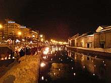
A canal adorned with Victorian-style street lamps runs through Otaru. The city attracts a large number of Japanese tourists as well as Russian visitors.
A popular attraction on the west side of the city is Nishin Goten (herring mansion). This large wooden building was built in 1897 and was once the house of Fukumatsu Tanaka, a magnate of the herring fishing industry. It was originally built in nearby Tomari village and moved from there in 1958. Visitors can clearly see the difference between the squalid conditions of the first floor sleeping quarters of 120 workers and the ground floor luxury of the magnate’s rooms.
Another notable building is the Sakaushi residence, constructed by Yoshiya Tanoue, a pupil of Frank Lloyd Wright.[3][4]
The Tomioka Catholic church is also a popular spot. Many of the buildings have been designated as landmark architecture[5]
In the nearby village of Asarigawa Onsen a new boutique resort catering for outdoor leisure activity is under development by the Wisbey brothers, scheduled for completion in 2017.
Otaru is well known for its beer, and Otaru Beer, next to the canal, is a popular restaurant with a medieval theme. Otaru is also known for the freshness of its sushi. The town also has substantial shopping arcades and bazaars, but fewer than nearby Sapporo.
Otaru's prominent industries are arts and crafts, such as studio glass and musical boxes.
Tenguyama
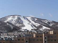
Otaru is an important port for Sapporo, and part of this hilly city is on the lower slopes of Tenguyama, a good place for skiing and other winter sports and one that is accessible via Otaru Tenguyama Ropeway.
Sister cities
-
 Nakhodka, Primorsky Krai, Russia[6]
 -
 Dunedin, New Zealand
 -
 Gangseo District, Seoul, South Korea
Notable people
- Seiji Aochi, ski jumper
- Yōko Asagami, voice actor
- Gennosuke Fuse, anatomist
- Sei Itō, author
- Chiaki Kawamata, author
- Yukie Kawamura, actress
- Masaki Kobayashi, film director
- Takiji Kobayashi, author
- Masaru Konuma, film director
- Kōtetsuyama Toyoya, sumo wrestler
- Natsuhiko Kyogoku, author
- Motosaburo Masuyama, statistician
- Hideharu Miyahira, ski jumper
- Nobuko Miyamoto, actress
- Tetsuya Mizuguchi, video game designer
- Takiko Mizunoe, actress
- Maki Murakami, manga artist
- Hideo Murota, actor
- Nobuo Nakamura, actor
- Tetsuya Okabe, Alpine ski racer
- Yoko Takahashi, fighter
- Miyoshi Umeki, Academy Award winning actress and standards singer
- Hirokazu Yagi, ski jumper
- Akiko Yamanaka, politician
- Ichiro Yamaguchi, musician (Sakanaction)
- Sawao Yamanaka, musician (The Pillows)
- Kazumi Yamashita, manga artist
See also
References
- 1 2 "観測史上1~10位の値(年間を通じての値)". Data.jma.go.jp. Retrieved 2014-08-20.
- ↑ US Department of State. (1906). A digest of international law as embodied in diplomatic discussions, treaties and other international agreements (John Bassett Moore, ed.), Vol. 5, p. 759.
- ↑ http://www.otaru-works.com/
- ↑ http://www.city.otaru.lg.jp.e.go.hp.transer.com/simin/gakushu_sports/kenzo/f_s/f_s74.html
- ↑ http://www.city.otaru.lg.jp.e.go.hp.transer.com/simin/gakushu_sports/kenzo/f_s/f_s70.html
- ↑ Sister Cities of Otaru
External links
| Wikimedia Commons has media related to Otaru. |
-
 Otaru travel guide from Wikivoyage
 - Official website (Japanese)
- Japan National Tourist Organization's Otaru page (English)