Otowi Historic District
|
Otowi Historic District | |
|
Buildings at Otowi Crossing | |
  | |
| Nearest city | Santa Fe, New Mexico |
|---|---|
| Area | 29 acres (12 ha) |
| Built | 1886 |
| Built by | Union Bridge Company |
| Architectural style | Pueblo |
| NRHP Reference # | 75001170[1] |
| Added to NRHP | December 4, 1975 |
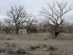
The Otowi Historic District is a 29-acre (12 ha) historic district in northern Santa Fe County, New Mexico, having four contributing buildings and three contributing structures that was listed on the National Register of Historic Places in 1975.[1]
Otowi (Tewa, p'otsuivi, “gap where water sinks”)[2] is a place on the west bank of the Rio Grande at the head of White Rock Canyon. Established in 1886 with the name White Rock Canon, it was little more than a station and river crossing on the D&RGW’s Santa Fe Branch, the narrow-gauge railroad popularly known as the Chili Line.
In 1923, nearby Los Alamos Ranch School requested a post office here using the ranch name. But a place near Las Vegas already had that name, so three other names were submitted and the U.S. Post Office Department chose Otowi. A single-lane, suspension road bridge was built in 1924. The railroad was removed and the post office closed in 1941. When Los Alamos Ranch School was taken over by the U.S. Government in 1943 to become the secret Los Alamos nuclear physics laboratory, virtually all of the traffic serving the town and laboratory travelled on New Mexico State Road 4 (now renumbered NM 502), crossing the river at Otowi.
This place is the setting for Peggy Pond Church’s historical memoir, The House at Otowi Bridge, (1960) which chronicles the life of Edith Warner from 1921 to 1951. She was postmistress and shopkeeper in the early years, and later the hostess of tea rooms which became popular with scientists from the Manhattan Project.
See also
References
- 1 2 National Park Service (2010-07-09). "National Register Information System". National Register of Historic Places. National Park Service.
- ↑ http://www.ghosttowns.com/states/nm/otowi
| Topics | |
|---|---|
| Lists by states |
|
| Lists by insular areas | |
| Lists by associated states | |
| Other areas | |
| |
Coordinates: 35°52′28.9″N 106°8′30.5″W / 35.874694°N 106.141806°W