Paw Paw, Illinois
| Village of Paw Paw | |
| Village | |
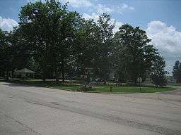 Chicago Road as it enters the village of Paw Paw. | |
| Country | United States |
|---|---|
| State | Illinois |
| County | Lee |
| Coordinates | 41°41′16″N 88°58′57″W / 41.68778°N 88.98250°WCoordinates: 41°41′16″N 88°58′57″W / 41.68778°N 88.98250°W |
| Area | 0.59 sq mi (1.53 km2) |
| - land | 0.59 sq mi (2 km2) |
| - water | 0.00 sq mi (0 km2), 0% |
| Population | 870 (2010) |
| Density | 1,506.2/sq mi (581.5/km2) |
| Timezone | CST (UTC-6) |
| - summer (DST) | CDT (UTC-5) |
| Postal code | 61353 |
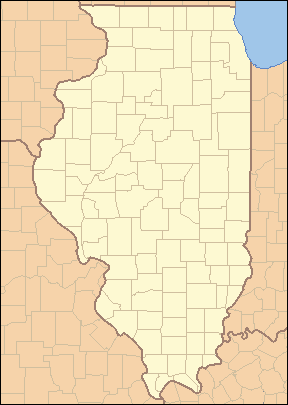 Location of Paw Paw within Illinois | |
 Location of Illinois in the United States | |
Paw Paw is a village in Lee County, Illinois, United States. As of the 2010 census, the village was home to 870 people, up from 852 at the 2000 census. It was settled in the mid 19th century and by 1878 the village had a railroad connection. Paw Paw is home to a house which is listed on the U.S. National Register of Historic Places and was the recipient of a 2005 federal grant to construct a water tower.
History
In 1829, [there appears to be something missing here as the sentence later refers to a trail that is not previously mentioned] present-day Chicago Road was part of the Frink and Walker stagecoach line from Galena, Illinois to Chicago, though the Potawatomi Indians were the first to use the trail. The tribe didn't turn over the area to the U.S. government until 1833. Frink and Walker also held the mail contract for the area's settlers. The route became popular and garnered a mention in the work of writer Margaret Fuller.[1]
Paw Paw's first permanent resident was David A. Town in 1834, a native of Vermont, Town settled on the south east side of a 2,000-acre (8 km2) wooded grove. The first cabin was built the next spring by Edward Butterfield on the site of present-day Paw Paw. This first house also held the village's first store and would eventually become the first structure in town to burn. During its earliest days the town was sectioned off into East, West and South Paw Paw, all of which became known as simply Paw Paw. In 1837, the village got its first postmaster, William Rodgers. Before Rodgers the nearest post office was 20 miles away in Somonauk. In 1839, a new road was constructed which allowed mail to be carried from Paw Paw to Princeton. The first stage coach station (known as a "Tavern") was built along Chicago Road and operated by Isaac Balding. Balding operated the station until the railroad came to town several years later.[2]
Though settlement in present-day Paw Paw began during the 1830s, by 1847 there were probably no more than 50 people in the village. The name Paw Paw was derived from a nearby grove of Pawpaw trees on the edge of a 2,000-acre (8 km2) forest. American general Winfield Scott is credited with being the first person of European ancestry to discover the area. The area that Paw Paw is located in was home to more than one stand of Paw Paw trees, thus more than one settlement took the name Paw Paw. To avoid confusion the townspeople renamed the village Wyoming Township. The new name came from the Wyoming Valley in Pennsylvania, where many of Paw Paw's earliest settlers originated.[1] The Wyoming Valley was the scene of a massacre during the American Revolution in which over 300 American settlers were killed by Native Americans allied with the British.[1] Many of Paw Paw's early settlers shared surnames with those who are listed as having been involved in the fighting and massacre.[1]
In 1850, Wyoming Township experienced a growth spurt despite being passed over for the coveted railroad link, by this time there were several businesses and a school. By 1878, the village finally got a railroad connection, was home to two newspapers, three churches and was christened, officially, as Paw Paw.[1] The village was officially established in 1882 and is celebrating its 125th anniversary in 2007.[3]
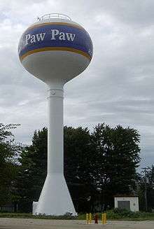
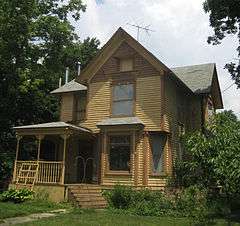
In 2005, the village received some U.S. federal government attention. On May 22 of that year, a local Queen Anne style house, the Stephen Wright House was listed on the U.S. National Register of Historic Places, it is the only property with that designation in Paw Paw.[4] The same year the village was the recipient of an US$192,000 United States Environmental Protection Agency earmark to construct an elevated water tower.[5]
Demographics
| Historical population | |||
|---|---|---|---|
| Census | Pop. | %± | |
| 1880 | 476 | — | |
| 1900 | 765 | — | |
| 1910 | 709 | −7.3% | |
| 1920 | 665 | −6.2% | |
| 1930 | 559 | −15.9% | |
| 1940 | 523 | −6.4% | |
| 1950 | 594 | 13.6% | |
| 1960 | 725 | 22.1% | |
| 1970 | 846 | 16.7% | |
| 1980 | 839 | −0.8% | |
| 1990 | 791 | −5.7% | |
| 2000 | 852 | 7.7% | |
| 2010 | 870 | 2.1% | |
| Est. 2015 | 821 | [6] | −5.6% |
As of the census[8] of 2000, there were 852 people, 342 households, and 228 families residing in the village. The population density was 1,506.2 people per square mile (577.1/km²). There were 359 housing units at an average density of 634.7 per square mile (243.2/km²). The racial makeup of the village was 98.71% White, 0.12% Native American, 0.35% Asian, and 0.82% from two or more races. Hispanic or Latino of any race were 1.17% of the population.
There were 342 households out of which 31.3% had children under the age of 18 living with them, 54.1% were married couples living together, 7.9% had a woman householder with no husband present, and 33.3% were non-families. 30.4% of all households were made up of individuals and 15.5% had someone living alone who was 65 years of age or older. The average household size was 2.49 and the average family size was 3.09.
In the village the population was spread out with 27.7% under the age of 18, 6.9% from 18 to 24, 27.1% from 25 to 44, 23.1% from 45 to 64, and 15.1% who were 65 years of age or older. The median age was 38 years. For every 100 women there were 99.5 men. For every 100 women age 18 and over, there were 97.4 men.
The median income for a household in the village was $37,563, and the median income for a family was $47,500. Men had a median income of $36,833 versus $22,000 for women. The per capita income for the village was $17,461. About 2.9% of families and 5.9% of the population were below the poverty line, including 10.7% of those under age 18 and 5.9% of those age 65 or over.
Geography
Paw Paw is located at 41°41′16″N 88°58′57″W / 41.68778°N 88.98250°W (41.687856, -88.982577).[9]
According to the 2010 census, Paw Paw has a total area of 0.59 square miles (1.53 km2), all land.[10] The village is located within close reach of an exit on and off Interstate 39.
Climate
Humid continental climate is a climatic region typified by large seasonal temperature differences, with warm to hot (and often humid) summers and cold (sometimes severely cold) winters. The Köppen Climate Classification subtype for this climate is "Dfa". (Hot Summer Continental Climate).[11]
| Climate data for Paw Paw, Illinois | |||||||||||||
|---|---|---|---|---|---|---|---|---|---|---|---|---|---|
| Month | Jan | Feb | Mar | Apr | May | Jun | Jul | Aug | Sep | Oct | Nov | Dec | Year |
| Average high °C (°F) | −3 (27) |
−1 (31) |
7 (44) |
15 (59) |
21 (70) |
27 (80) |
28 (83) |
27 (80) |
23 (74) |
17 (62) |
8 (46) |
0 (32) |
14 (57) |
| Average low °C (°F) | −18 (0) |
−10 (14) |
−4 (25) |
2 (36) |
8 (47) |
14 (57) |
16 (61) |
15 (59) |
11 (51) |
4 (39) |
−2 (29) |
−9 (16) |
3 (37) |
| Average precipitation mm (inches) | 41 (1.6) |
33 (1.3) |
61 (2.4) |
86 (3.4) |
99 (3.9) |
109 (4.3) |
91 (3.6) |
91 (3.6) |
94 (3.7) |
74 (2.9) |
61 (2.4) |
48 (1.9) |
886 (34.9) |
| Average precipitation days | 8 | 7 | 9 | 10 | 11 | 10 | 8 | 9 | 8 | 8 | 8 | 8 | 104 |
| Source: Weatherbase [12] | |||||||||||||
Education
Public education in Paw Paw is overseen by Unit 271 school district. The district operates Paw Paw Junior and Senior High School as well as an elementary school. Both schools are located in the village of Paw Paw.[13]
Notable people
- George Bristow, outfielder for the Cleveland Spiders
- Robben Wright Fleming, educator
- Jesse Harper, football coach
- Carol Hart, World-famous surgeon
Notes
- 1 2 3 4 5 Zeimetz, Lisa. "Stephen Wright House," (PDF), National Register of Historic Places Nomination Form, 1 April 2005, HAARGIS Database, Illinois Historic Preservation Agency. Retrieved 28 June 2007.
- ↑ "Paw Paw," Lee County Historical Society, The History of Lee County. Retrieved 28 June 2007. History paragraph reference.
- ↑ "Paw Paw 125th anniversary DVD completed," Ottawa Times 25 June 2007. Retrieved 28 June 2007.
- ↑ National Park Service (2010-07-09). "National Register Information System". National Register of Historic Places. National Park Service.
- ↑ "Paw Paw, Illinois earmarks," The White House Office of Management and Budget, 26 February 2007. Retrieved 28 June 2007.
- ↑ "Annual Estimates of the Resident Population for Incorporated Places: April 1, 2010 to July 1, 2015". Retrieved July 2, 2016.
- ↑ "Census of Population and Housing". Census.gov. Archived from the original on May 11, 2015. Retrieved June 4, 2015.
- ↑ "American FactFinder". United States Census Bureau. Retrieved 2008-01-31.
- ↑ "US Gazetteer files: 2010, 2000, and 1990". United States Census Bureau. 2011-02-12. Retrieved 2011-04-23.
- ↑ "G001 - Geographic Identifiers - 2010 Census Summary File 1". United States Census Bureau. Retrieved 2015-12-25.
- ↑ Climate Summary
- ↑ "Weatherbase.com". Weatherbase. 2013. Retrieved on June 5, 2013.
- ↑ Paw Paw Community Unit School District 271, Official site. Retrieved 28 June 2007.
Municipalities and communities of Lee County, Illinois, United States | ||
|---|---|---|
| Cities | ||
| Villages | ||
| Townships | ||
| Unincorporated communities |
| |
| Footnotes | ‡This populated place also has portions in an adjacent county or counties | |