Petit Manan Light
 | |
 | |
| Location | Petit Manan Island, Maine |
|---|---|
| Coordinates | 44°22′3.29″N 67°51′51.7″W / 44.3675806°N 67.864361°WCoordinates: 44°22′3.29″N 67°51′51.7″W / 44.3675806°N 67.864361°W |
| Year first constructed | 1817 |
| Year first lit | 1855 (current structure) |
| Automated | 1972 |
| Tower shape | Conical Granite Tower |
| Markings / pattern | Natural Granite |
| Focal height | 123 feet (37 m) |
| Original lens | Second Order Fresnel lens |
| Current lens | VRB-25 |
| Range | 19 nautical miles (35 km; 22 mi) |
| Characteristic | Fl W 10s |
| Fog signal | HORN: 1 every 30s |
| USCG number | |
|
Petit Manan Light Station | |
| Nearest city | Milbridge, Maine |
| Built | 1855 |
| Architect | US Army Corps. of Engineers |
| Architectural style | Late Victorian |
| NRHP Reference # | 87001879[3] |
| Added to NRHP | October 30, 1987 |
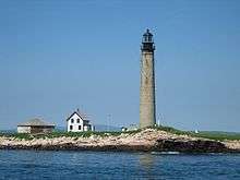
Petit Manan Light is a lighthouse on Petit Manan Island, Maine. The island is at the end of a series of ledges extending out from Petit Manan Point, between Dyer Bay and Pigeon Hill Bay, that projects into the Gulf of Maine.
Description
The Petit Manan light station consists of a light tower, keeper's house, boathouse, and other outbuildings. The tower is a circular granite stone structure, 109 feet (33 m) in height and 20 feet (6.1 m) in diameter at its base. Atop this is mounted a two-story twelve-sided lantern house, placing the light's focal plan at 123 feet (37 m). The inside of the tower is lined with brick, and has iron stairs. The keeper's house is a two-story wood frame structure. Accompanying outbuildings include a rain shed (possibly built in 1868), paint shed (1876), generator building (1887), and boathouse (probably built 1868, and enlarged 1900).[4]
History
It was first established in 1817 as a small stone lighthouse. The present structure was built in 1855, and the keeper's house in 1875. The original lens was an enormous second order Fresnel which is now on display at the Maine Lighthouse Museum in Rockland, Maine.[5] Being in a very exposed position, it has suffered storm damage from time to time. In 1856 a storm knocked out some of its blocks. In 1869, it swayed enough that the weights that turn the lens fell, damaging the staircase. Finally, in 1887, iron tie rods were installed to stabilize it.[1] The light was automated in 1972, at which time the Fresnel lens was removed.[4] The light was out of service for two months in 2001 after a nor'easter damaged its submarine power cable; as a result it was converted to solar power later that year.[5]
The light station is part of the Petit Manan Wildlife Refuge and is not open to the public. There is a colony of breeding puffins on the island. There are boat tours to the island.[1]
It is the second tallest light tower in Maine and is very similar to the Boon Island Light which is slightly taller and was built in the same year. Petit Manan Light was listed on the National Register of Historic Places as Petit Manan Light Station on October 30, 1987.[3]
See also
References
- 1 2 3 "Historic Light Station Information and Photography: Maine". United States Coast Guard Historian's Office. 2009-08-06.
- ↑ United States Coast Guard (2009). Light List, Volume I, Atlantic Coast, St. Croix River, Maine to Shrewsbury River, New Jersey. p. 18.
- 1 2 National Park Service (2009-03-13). "National Register Information System". National Register of Historic Places. National Park Service.
- 1 2 "NRHP nomination for Petit Manan Light" (PDF). National Park Service. Retrieved 2015-12-06.
- 1 2 Rowlett, Russ (2009-08-06). "Lighthouses of the United States: Eastern Maine". The Lighthouse Directory. University of North Carolina at Chapel Hill.

| Topics | |
|---|---|
| Lists by states |
|
| Lists by insular areas | |
| Lists by associated states | |
| Other areas | |
| |