Picayune, Mississippi
| Picayune, Mississippi | |
|---|---|
| City | |
|
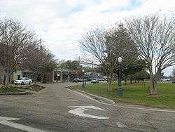
Downtown Picayune | |
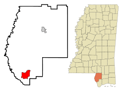 Location of Picayune, Mississippi | |
 Picayune, Mississippi Location in the United States | |
| Coordinates: 30°31′41″N 89°40′49″W / 30.52806°N 89.68028°WCoordinates: 30°31′41″N 89°40′49″W / 30.52806°N 89.68028°W | |
| Country | United States |
| State | Mississippi |
| County | Pearl River |
| Area | |
| • Total | 11.8 sq mi (30.6 km2) |
| • Land | 11.8 sq mi (30.5 km2) |
| • Water | 0.0 sq mi (0.1 km2) |
| Elevation | 73 ft (22 m) |
| Population (2010) | |
| • Total | 10,878 |
| • Density | 921.8/sq mi (345.8/km2) |
| Time zone | Central (CST) (UTC-6) |
| • Summer (DST) | CDT (UTC-5) |
| ZIP code | 39466 |
| Area code(s) | 601 |
| FIPS code | 28-57160 |
| GNIS feature ID | 0675698 |
| Website | http://www.picayune.ms.us/, http://www.maroontide.com/ |
Picayune is the largest city in Pearl River County, Mississippi. The population was 10,878 at the 2010 census. Picayune was added to the New Orleans metropolitan area in 2014.[1] Picayune is located approximately 45 miles (72 km) from New Orleans, Hattiesburg and Gulfport-Biloxi. The Stennis Space Center is 10 miles (16 km) away.
History
Picayune was founded in 1904, named by Eliza Jane Poitevent Nicholson, the owner and publisher of the New Orleans Daily Picayune, a newspaper named for the Spanish coin.
Hurricane Katrina
While Picayune received extensive damage from Hurricane Katrina, it was not as severe as in other nearby cities. This has caused it to become the permanent home for many who relocated from the New Orleans area and from the Mississippi Gulf Coast – who were seeking a safer home site with easy commuting to those areas.
The bulk of the Katrina damage in Picayune was caused by high winds. This resulted in widespread roof, window, and fence damage. The wind also caused hundreds, if not thousands, of downed trees – and power outages of up to several months.
Geography
According to the United States Census Bureau, the city has a total area of 11.8 square miles (31 km2), of which 11.8 square miles (31 km2) is land and 0.04 square miles (0.10 km2) (7.34%) is water.
Demographics
| Historical population | |||
|---|---|---|---|
| Census | Pop. | %± | |
| 1910 | 846 | — | |
| 1920 | 2,479 | 193.0% | |
| 1930 | 4,698 | 89.5% | |
| 1940 | 5,129 | 9.2% | |
| 1950 | 6,707 | 30.8% | |
| 1960 | 7,834 | 16.8% | |
| 1970 | 10,467 | 33.6% | |
| 1980 | 10,361 | −1.0% | |
| 1990 | 10,633 | 2.6% | |
| 2000 | 10,535 | −0.9% | |
| 2010 | 10,878 | 3.3% | |
| Est. 2015 | 10,675 | [2] | −1.9% |
As of the census[4] of 2000, there were 10,535 people, 4,100 households, and 2,865 families residing in the city. The population density was 895.6 people per square mile (345.9/km²). There were 4,568 housing units at an average density of 388.3 per square mile (150.0/km²). The racial makeup of the city was 62.02% White, 35.92% African American, 0.38% Native American, 0.30% Asian, 0.05% Pacific Islander, 0.18% from other races, and 1.15% from two or more races. Hispanic or Latino of any race were 1.15% of the population.
There were 4,100 households out of which 31.8% had a children under the age of 18 living with them, 45.0% were married couples living together, 20.8% had a female householder with no husband present, and 30.1% were non-families. 26.4% of all households were made up of individuals and 11.8% had someone living alone who was 65 years of age or older. The average household size was 2.54 and the average family size was 3.06.
In the city the population was spread out with 27.0% under the age of 18, 9.4% from 18 to 24, 25.5% from 25 to 44, 23.0% from 45 to 64, and 15.1% who were 65 years of age or older. The median age was 36 years. For every 100 females there were 82.8 males. For every 100 females age 18 and over, there were 79.2 males.
The median income for a household in the city is $26,958, and the median income for a family was $33,260. Males had a median income of $31,438 versus $20,035 for females. The per capita income for the city was $15,798. About 18.9% of families and 20.8% of the population were below the poverty line, including 28.2% of those under age 18 and 17.6% of those age 65 or over.
Education
The City of Picayune is served by the Picayune School District.
Picayune Junior High School serves as the middle school for grades 7 and 8.[5] Picayune Memorial High School is the local high school. The school's mascot is the Maroon Tide.
The Center of Alternate Education is also located in Picayune.
Elementary schools
- Nicholson Elementary
- Roseland Park Elementary
- South Side Elementary
- West Side Elementary
Library
The Margaret Reed Crosby Memorial Library serves Picayune and is the headquarters of the Pearl River County Library System.
Media
Newspaper
Picayune's local newspaper is the Picayune Item.
Radio
The local radio station is WRJW 1320-AM.
Infrastructure
Transportation
Amtrak's Crescent train connects Picayune with the cities of New York, Philadelphia, Baltimore, Washington, Charlotte, Atlanta, Birmingham, and New Orleans. The Amtrak station is situated at 100 South U.S. Route 11. There is daily service in each direction.
U.S. 11 is the main highway through Picayune. Interstate 59 (via Interstate 10) connects Picayune with New Orleans, LA, to the south and Hattiesburg, MS, Meridian, MS, and Birmingham, AL, to the north.
Mississippi Highway 43 is the main connection to and from the east, connecting to Interstate 10 near Kiln, MS.
Picayune Municipal Airport (KMJD) has a 5,000 ft (1,500 m) runway and is a popular destination for private fixed-wing and rotary aircraft visiting the New Orleans area. Rental car, taxi and limousine services are available.
Railroads
Major highways
Notable people
- Jonathan Bender, former professional basketball player.
- Jon Heidenreich, former professional football player and wrestler.
- T. J. House, professional baseball player.
- Rhyne Hughes, professional baseball player.
- Sammy Martin, professional football player.
- Michael Holloway Perronne, writer.
Points of interest
References
| Wikimedia Commons has media related to Picayune, Mississippi. |
- ↑ http://www.whitehouse.gov/sites/default/files/omb/bulletins/2013/b13-01.pdf
- ↑ "Annual Estimates of the Resident Population for Incorporated Places: April 1, 2010 to July 1, 2015". Retrieved July 2, 2016.
- ↑ "Census of Population and Housing". Census.gov. Retrieved June 4, 2015.
- ↑ "American FactFinder". United States Census Bureau. Retrieved 2008-01-31.
- ↑ https://www.edline.net/pages/pcu_pjh
Municipalities and communities of Pearl River County, Mississippi, United States | ||
|---|---|---|
| Cities | 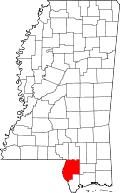 | |
| CDPs |
| |
| Other unincorporated communities | ||
| Footnotes | ‡This populated place also has portions in an adjacent county or counties | |
.svg.png)