Poinciana, Florida
| Poinciana, Florida | |
|---|---|
| CDP | |
 Location in Osceola and Polk counties in the state of Florida | |
| Coordinates: 28°9′21″N 81°28′35″W / 28.15583°N 81.47639°WCoordinates: 28°9′21″N 81°28′35″W / 28.15583°N 81.47639°W | |
| Country |
|
| State |
|
| County | Polk/Osceola |
| Area | |
| • Total | 35.3 sq mi (91.5 km2) |
| • Land | 35.1 sq mi (90.9 km2) |
| • Water | 0.2 sq mi (0.6 km2) |
| Elevation | 66 ft (20 m) |
| Population (2010) | |
| • Total | 53,193 |
| • Density | 1,500/sq mi (580/km2) |
| Time zone | Eastern (EST) (UTC-5) |
| • Summer (DST) | EDT (UTC-4) |
| ZIP code | 34758, 34759 |
| Area code(s) | 407, 321, 863 |
| FIPS code | 12-57900[1] |
| GNIS feature ID | 1853279[2] |
Poinciana is a settlement and census-designated place (CDP) in Osceola and Polk counties in the U.S. state of Florida. It lies southwest of Kissimmee and approximately 14 miles (23 km) east of Haines City. As of the 2010 United States Census, the CDP had a population of 53,193.[3]
As of April 2012 the population of the 10 Villages which make up the Association of Poinciana Villages (APV), which covers a wider area than the CDP, was reported as 69,857.[4] According to the latest census reports the adjoining tracts outside the CDP represent an additional 29,914 persons. Depending on the definition, the greater Poinciana Area represents a population of between 53,193 and 83,107. This puts Poinciana as one of the fastest growth areas for Central Florida over the past decade.
Transportation
U.S. Highway 17/92 (here part of the Orange Blossom Trail) runs through the north of Poinciana.
Local bus service is provided to Kissimmee and Haines City by the Lynx network. Poinciana is planned to be the southern terminus of the SunRail system.
The Poinciana Parkway (State Road 538), a toll road to connect Poinciana more directly to Interstate 4, was opened on April 30, 2016.
Geography
Poinciana is located at 28°9′21″N 81°28′35″W / 28.15583°N 81.47639°W (28.155768, -81.476502).[5]
According to the United States Census Bureau, the CDP has a total area of 35.3 square miles (91 km2), of which 35.1 square miles (91 km2) is land and 0.2 square miles (0.52 km2), or 0.68%, is water.
Subdivisions
Poinciana was planned as a Planned Unit Development (PUD). Most of the PUD was developed in 10 Villages, which form the Association of Poinciana Villages (APV). Four of the villages are in Osceola County and six are in Polk County.[4] Located on approximately 47,000 acres (190 km²), the villages are a deed-restricted community, governed by a homeowner association, the APV. Solivita (Village 10), one of the Villages within Polk County, is a 55+ community, and comprises two Community Development Districts, Poinciana CDD and Poinciana West CDD.[6]
Neighbor subdivisions such as Waterford, Little Creek, Brighton Lakes, Oak Hammock Preserve, Crescent Lakes, Trafalgar, Doral, Isles of Bellalago, Cypress Cove, Cypress Woods, Deerwood, Wilderness, Bellalago, etc. are outside the CDP. Many of these subdivisions were defined in the original Poinciana boundary PUD but were developed as separate communities outside the APV.
History
Poinciana was planned in the 1960s. The original developer was Gulf American Corporation. Poinciana was conceived as a retirement destination, and the first homes were built in 1973 around the Poinciana Golf and Racquet Club. Since the mid-1980s the developer has been AV Homes (formerly Avatar Holdings).[7] By 1994 the population had only risen to about 8,000, but since then growth has been rapid.
Notable person
Pro wrestler Rikishi resides in Poinciana.
Demographics
| Historical population | |||
|---|---|---|---|
| Census | Pop. | %± | |
| 2000 | 13,647 | — | |
| 2010 | 53,193 | 289.8% | |
| source:[8] | |||
As of the census[1] of 2010 there were 53,193 residing in the CDP. The racial makeup of the CDP was 22.6% White non-Hispanic, 21.3% African American, 0.2% Native American, 1.7% Asian, 0.20% Pacific Islander, 0.7% from other races, and 2.2% from two or more races. Hispanic or Latino of any race were 51.2% of the population.
In addition there were 29,914 residing in the non-CDP neighborhoods. Poinciana is 35.8% Puerto Rican and is considered the "Little Puerto Rico" of Florida.
For census 2000 there were 4,153 households out of which 50.3% had children under the age of 18 living with them, 65.5% were married couples living together, 15.4% had a female householder with no husband present, and 14.2% were non-families. 10.5% of all households were made up of individuals and 3.7% had someone living alone who was 65 years of age or older. The average household size was 3.29 and the average family size was 3.49. This information will be updated for census 2010 when it becomes available.
In the 2010 Census CDP the population was spread out with 29.27% under the age of 18, and 70.73% age 18 and over. The non CDP population was 27.4% under age of 18 and 72.6% over.
In 2000 the median income for a household in the CDP was $37,172, and the median income for a family was $37,688. Males had a median income of $26,860 versus $20,934 for females. The per capita income for the CDP was $12,590. About 12.0% of families and 12.8% of the population were below the poverty line, including 17.9% of those under age 18 and 12.3% of those age 65 or over. Likewise, 2010 income information will be updated when it become available.
Education
- Osceola County
- Pre-Kindergarten Schools
- Liberty High School (Pre-K)
- Poinciana 247 Pre-K & V.P.K. (Private School)
- Reedy Creek Elementary (Pre-K)
- Elementary Schools
- Bellalago Academy (K-8) (District managed charter school)
- Renaissance Charter School at Poinciana (K-8)
- Chestnut Elementary (CES)
- Deerwood Elementary (DWE)
- Koa Elementary
- Poinciana Academy Of Fine Arts (PAFA)
- Reedy Creek Elementary (RCES)
- Mater Brighton Lakes Academy
- Middle Schools
- Bellalago Academy
- Discovery Intermediate (DIS)
- Horizon Middle (HMS)
- Mater Brighton Lakes Academy (MBLA)
- High Schools
- Poinciana High (PHS)
- New Dimensions (NDHS) (public charter high school)
- Liberty High (LHS):
- Pre-Kindergarten Schools
- Polk County
- Elementary Schools
- Palmetto Elementary (pre Kindergarten-4th grade)
- Laurel Elementary (Up to 4th grade)
- Middle Schools
- Lake Marion Creek Middle School (5-8) (LMC)
- Elementary Schools
Libraries
- School District of Osceola County
- Polk County Public Schools
- Poinciana Branch Library - Osceola library system
See also
References
- 1 2 "American FactFinder". United States Census Bureau. Retrieved 2008-01-31.
- ↑ "US Board on Geographic Names". United States Geological Survey. 2007-10-25. Retrieved 2008-01-31.
- ↑ "Race, Hispanic or Latino, Age, and Housing Occupancy: 2010 Census Redistricting Data (Public Law 94-171) Summary File (QT-PL), Poinciana CDP, Florida". U.S. Census Bureau, American FactFinder 2. Retrieved August 5, 2011.
- 1 2 "Association of Poinciana Villages: Masterboard". Retrieved 2013-02-01.
- ↑ "US Gazetteer files: 2010, 2000, and 1990". United States Census Bureau. 2011-02-12. Retrieved 2011-04-23.
- ↑ Poinciana CDD 2012 District Improvement Plan
- ↑ AV Homes: Investor Relations
- ↑ "CENSUS OF POPULATION AND HOUSING (1790-2010)". U.S. Census Bureau. Retrieved 2010-07-17.
External links
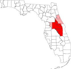
Municipalities and communities of Osceola County, Florida, United States | ||
|---|---|---|
| Cities | 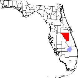 | |
| CDPs | ||
| Unincorporated communities |
| |
| Footnotes | ‡This populated place also has portions in an adjacent county or counties | |
Municipalities and communities of Polk County, Florida, United States | ||
|---|---|---|
| Cities | 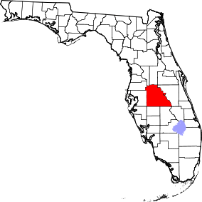 | |
| Towns | ||
| Village | ||
| CDPs | ||
| Unincorporated communities | ||
| Ghost town | ||
| Footnotes | ‡This populated place also has portions in an adjacent county or counties | |
| Attractions |
|  |
|---|---|---|
| Colleges and universities | ||
| Media |
| |
| Airports | ||
| Counties | ||
| Cities and towns 25k+ | ||
| Cities and towns 10k–25k | ||
‡ This populated place is included in the Orlando–Deltona–Daytona Beach, FL Combined Statistical Area. See also: | ||