Popocatépetl
| Popocatépetl | |
|---|---|
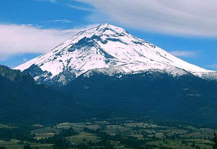 Popocatépetl from Amecameca (looking south-east) | |
| Highest point | |
| Elevation | 5,426 m (17,802 ft) [1] |
| Prominence | 3,020 m (9,910 ft) [2][3] |
| Isolation | 143 kilometres (89 mi) |
| Listing | |
| Coordinates | 19°01′20″N 98°37′40″W / 19.02222°N 98.62778°WCoordinates: 19°01′20″N 98°37′40″W / 19.02222°N 98.62778°W |
| Geography | |
 Popocatépetl Mexico | |
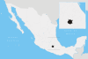
| Location | Mexico-Puebla-Morelos, Mexico |
| Geology | |
| Mountain type | Stratovolcano |
| Last eruption |
2005 to 2016 (ongoing)[4] |
| Climbing | |
| Easiest route | rock/snow climb |
Popocatépetl (Spanish pronunciation: [popokaˈtepetɬ]; Nahuatl: Popōcatepētl [popoːkaˈtepeːt͡ɬ]) is an active volcano, located in the states of Puebla, Mexico, and Morelos, in Central Mexico, and lies in the eastern half of the Trans-Mexican volcanic belt. At 5,426 m (17,802 ft)[4] it is the second highest peak in Mexico, after Citlaltépetl (Pico de Orizaba) at 5,636 m (18,491 ft).
It is linked to the Iztaccihuatl volcano to the north by the high saddle known as the Paso de Cortés.[5]
Popocatépetl is 70 km (43 mi) southeast of Mexico City, from where it can be seen regularly, depending on atmospheric conditions. Until recently, the volcano was one of three tall peaks in Mexico to contain glaciers,[6] the others being Iztaccihuatl and Pico de Orizaba. In the 1990s, the glaciers such as Glaciar Norte (North Glacier) greatly decreased in size, partly due to warmer temperatures but largely due to increased volcanic activity.[7] By early 2001, Popocatépetl's glaciers were gone; ice remained on the volcano, but no longer displayed the characteristic features of glaciers such as crevasses.[8][9][10]
Lava erupting from Popocatépetl has historically been predominantly andesitic, but it has also erupted large volumes of dacite.[11] Magma produced in the current cycle of activity tends to be a mixture of the two.[12]
Toponymy
The name Popocatépetl comes from the Nahuatl words popōca [poˈpoːka] 'it smokes' and tepētl [ˈtepeːt͡ɬ] 'mountain', meaning Smoking Mountain. The volcano is also referred to by Mexicans as El Popo. The alternate nickname Don Goyo comes from the mountain's association in the lore of the region with San Gregorio (St. Gregory), "Goyo" being a nickname-like short form of Gregorio.[13]
Geology
The stratovolcano contains a steep-walled, 400 m × 600 m (1,300 ft × 2,000 ft) wide crater. The generally symmetrical volcano is modified by the sharp-peaked Ventorrillo on the NW, a remnant of an earlier volcano. At least three previous major cones were destroyed by gravitational failure during the Pleistocene, producing massive debris avalanche deposits covering broad areas south of the volcano. The modern volcano was constructed to the south of the late-Pleistocene to Holocene El Fraile cone.[4] Three major plinian eruptions, the most recent of which took place about 800 AD, have occurred from Popocatépetl since the mid Holocene, accompanied by pyroclastic flows and voluminous lahars that swept basins below the volcano.[4]
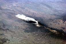

According to paleomagnetic studies, the volcano is about 730,000 years old. The elevation at the peak is 5,450 m (17,880 ft). The volcano is cone shaped with a diameter of 25 km (16 mi) at its base. The crater is elliptical with an orientation northeast-southwest. The walls of the crater vary from 600 to 840 m (1,970 to 2,760 ft) in height. Popocatépetl is currently active after being dormant for about half of last century. In 1991 the volcano's activity increased and since 1993 smoke can be seen constantly emanating from the crater.
Eruptions
Popocatépetl is the most active volcano in Mexico, having had more than 15 major eruptions since the arrival of the Spanish in 1519.
A violent VEI-6 eruption in the mid-to late first century CE may have caused the massive migrations that settled Teotihuacan, according to DNA analysis of teeth and bones.[14]
A major eruption occurred in 1947.
On December 21, 1994, the volcano spewed gas and ash which was carried as far as 25 km (16 mi) away by prevailing winds. The activity prompted the evacuation of nearby towns and scientists to begin monitoring for an eruption.[13]
In December 2000, tens of thousands of people were evacuated by the government based on the warnings of scientists. The volcano then made its largest display in 1,200 years.[9][10][15][16]
On December 25, 2005, the volcano's crater produced an explosion which ejected a large column of smoke and ash about 3 km (1.9 mi) into the atmosphere and expulsion of lava.
In January and February 2012, scientists observed increased volcanic activity at Popocatépetl. On January 25, 2012, an ash explosion occurred on the mountain causing much dust and ash to contaminate the atmosphere around it.[13]
On April 19, 2012, there were reports of superheated rock fragments being hurled into the air by the volcano. Ash and water vapor plumes were reported 15 times over 24 hours.[17]
On Wednesday May 8, 2013, at 7:28 pm local time, Popocatépetl erupted again with a high amplitude tremor that lasted and was recorded for 3.5 hours. It began with plumes of ash that rose 3 km into the air and began drifting W at first, but later began to drift ESE covering areas of the villages of San Juan Tianguismanalco, San Pedro Benito Juárez and the City of Puebla in smoke and ash. Explosions from the volcano itself subsequently ejected fragments of fiery volcanic rock to distances of 700 m from the crater.[18][19]
On July 4, 2013, due to several eruptions of steam and ash for at least 24 hours, at least six U.S. airlines canceled more than 40 flights into and out of Mexico City and Toluca airports that day.[20]
During 27 August–September 2014, CENAPRED reported explosions accompanied by steam-and-gas emissions with minor ash and ash plumes that rose 800-3,000 m above Popocatépetl’s crater and drifted W, SW, and WSW. On most nights incandescence was observed, increasing during times with larger emissions. On 1 September partial visibility due to cloud cover was reported. On 29 and 31 August the Washington VAAC reported discrete ash emissions.[21]
On January 7, 2015, CENAPRED reported that ash from recent explosions coats the snow on the volcano's upper slopes.
On March 28, 2016, an ash column 2,000 metres high was released, prompting the establishment of a 12-kilometer “security ring” around the summit.[22] On 3 April 2016, Popocatépetl erupted, spewing lava, ash and rock. [23]
Eruptions have continued in August 2016, with four discrete blasts on August 17.[24] There has been related activity at two volcanoes in Guatemala: Santa Maria's Santiaguito and also at Fuego.
This volcano is monitored by the Deep Earth Carbon Degassing Project.
History
The first Spanish ascent of the volcano was made by an expedition led by Diego de Ordaz in 1519.[25]:182 The early-16th-century monasteries on the slopes of the mountain are a World Heritage Site.
Picture gallery
 Popocatepetl from the north, viewed from Paso de Cortés
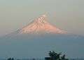 Popocatepetl at sunrise, looking west, from Puebla
 Popocatepetl at sunrise from Mexico City
 Popocatepetl viewed from Paso de Cortés
 Replica of “Grandeza Azteca” (Aztec greatness) by painter Jesús Helguera, depicting the legend of Popocatepetl.
See also
References
- ↑ Sources vary widely, on the elevation of Popocatépetl, with most giving a value at or slightly above 5,400 m. The 5,426 m figure given here is from the Smithsonian Institution-Global Volcanism Program.
- ↑ "Mexico Ultras" Peaklist.org. The prominence value given here of 3,020 m is based on a summit elevation of 5,400 m for Popocatépetl. Retrieved 2012-01-29.
- ↑ "Volcán Popocatépetl, Mexico" The prominence value given here of 3,020 m is interpolated from a summit elevation of 5,400 m for Popocatépetl. Peakbagger.com. Retrieved 2012-01-29.
- 1 2 3 4 "Popocatépetl". Global Volcanism Program. Smithsonian Institution. Retrieved 2008-12-18.
- ↑ John H. Beaman. The Timberlines of Iztaccihuatl and Popocatépetl, Mexico. Ecology Vol. 43, No. 3 (Jul., 1962), pp. 377-385
- ↑ Huggel, C., Delgado, H. (2000). "Glacier monitoring at Popocatépetl Volcano, México: glacier shrinkage and possible causes". In Hegg, C., Vonder Muehll, D. Beiträge zur Geomorphologie.- Proceedings Fachtagung der Schweizerischen Geomorphologischen Gesellschaft, 8-10 July 1999 (pdf). Bramois, WSL Birmensdorf. pp. 97–106. Retrieved 2012-04-17.
- ↑ Granados HD (1997). "The glaciers of Popocatépetl volcano (Mexico): Changes and causes". Quaternary International. 43–44: 53–60. Bibcode:1997QuInt..43...53G. doi:10.1016/S1040-6182(97)00020-7. Retrieved 2012-04-17.
- ↑ Delgado Granados H, Miranda PJ, Huggel C, Ortega del Valle S, Alatorre Ibargüengoitia MA (2007). "Chronicle of a death foretold: Extinction of the small-size tropical glaciers of Popocatépetl volcano (Mexico)". Global and Planetary Change. 56 (1–2): 13–22. Bibcode:2007GPC....56...13D. doi:10.1016/j.gloplacha.2006.07.010.
- 1 2 Huggel C, Schneider D, Julio Miranda P, Granados HD, Kääb A (2008). "Evaluation of ASTER and SRTM DEM data for lahar modeling: A case study on lahars from Popocatépetl Volcano, Mexico" (pdf). Journal of Volcanology and Geothermal Research. 170: 99–110. Bibcode:2008JVGR..170...99H. doi:10.1016/j.jvolgeores.2007.09.005. Retrieved 2012-04-17.
- 1 2 Julio-Miranda P, Delgado-Granados H, Huggel C, Kääb A (2008). "Impact of the eruptive activity on glacier evolution at Popocatépetl Volcano (México) during 1994–2004". Journal of Volcanology and Geothermal Research. 170 (1–2): 86–98. Bibcode:2008JVGR..170...86J. doi:10.1016/j.jvolgeores.2007.09.011.
- ↑ Sosa, G.; Gardner, J. E.; Lassiter, J. C. 2009. Magma evolution during the last 23 ky at Popocatepetl Volcano: insights from Sr, Nd, and Pb isotopes in plagioclase, pyroxene and pumice matrix. American Geophysical Union, Fall Meeting 2009, abstract #V51A-1658
- ↑ Martin, A. L.; Cifuentes, G.; Straub, S.; Mendiola, F. 2007. Magma Stagnation and Ascent at Popocatepetl Volcano, Mexico during the last 10 years. American Geophysical Union, Spring Meeting 2007, abstract #V42A-05
- 1 2 3 "Popocatépetl volcano eruptions". VolcanoDiscovery. Retrieved 2012-04-20.
- ↑ KPBS SECRETS OF THE DEAD: Teotihuacán’s Lost Kings
- ↑ "Residents on slopes of Popocatepetl Volcano heed evacuation notice". US Geological Survey. 2000. Retrieved 2012-04-20.
- ↑ Julio Miranda, P., Delgado Granados, H. (2003). "Fast hazard evaluation, employing digital photogrammetry on Popocatépetl glaciers", Mexico" (pdf). Geofísica Internacional. 42 (2): 275–283. Retrieved 2012-04-21.
- ↑ "Mexican volcano hurls hot rock into sky". CBC News. 2012-04-19. Retrieved 2012-04-20.
- ↑ Greenwood, Faine. "Mexico's Popocatépetl volcano has erupted". Global Post. Archived from the original on 7 July 2013. Retrieved 9 May 2013.
- ↑ "Popocatépetl volcano (Mexico): strong ash emissions and increase of activity". Volcano Discovery. Archived from the original on 7 July 2013. Retrieved 9 May 2013.
- ↑ "US AIRLINES CANCEL MEXICO FLIGHTS DUE TO VOLCANO". AP. Retrieved 4 July 2013.
- ↑ http://www.volcano.si.edu/volcano.cfm?vn=341090
- ↑ Mexico's Popocatépetl volcano spews ash and gas into sky
- ↑ Mexico's Popocatépetl volcano violently erupts, launching burning rocks
- ↑ Erik Klemetti, Science: "Here’s What’s Happening in This Volcanic Explosion at Guatemala’s Santiaguito"/Popocatépetl, Wired, 18 August 2016; accessed 19 August 2016
- ↑ Diaz, B., 1963, The Conquest of New Spain, London: Penguin Books, ISBN 0140441239
Further reading
- Secor, R. J. (2008). Mexico's Volcanoes: A Climbing Guide (3rd ed.). Mountaineers Books. pp. 160ff. ISBN 0-89886-798-3.
- "Popocatépetl". Global Volcanism Program. Smithsonian Institution. Retrieved 2008-12-18.
- Yarza de la Torre, Esperanza (1971). Volcanes de México (in Spanish). Aguilar. pp. 237ff.
External links
| North West |
| |
|---|---|---|
| North Central |
| |
| West |
| |
| East |
| |
| South West |
| |
| South Central |
| |
| South East |
| |
| ||