Uncompahgre Peak
| Uncompahgre Peak | |
|---|---|
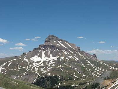 Uncompahgre Peak from the west | |
| Highest point | |
| Elevation | 14,321 ft (4365.0 m) [1] NAVD88 |
| Prominence | 4277 ft (1304 m) [2] |
| Isolation | 85.0 mi (136.8 km) [2] |
| Listing | |
| Coordinates | 38°04′18″N 107°27′44″W / 38.0716581°N 107.4620893°WCoordinates: 38°04′18″N 107°27′44″W / 38.0716581°N 107.4620893°W [1] |
| Geography | |
 Uncompahgre Peak | |
| Location | High point of Hinsdale County, Colorado, United States[2] |
| Parent range |
Highest summit of the San Juan Mountains[2] |
| Topo map |
USGS 7.5' topographic map Uncompahgre Peak, Colorado[3] |
| Climbing | |
| Easiest route | Hike (class 2) |
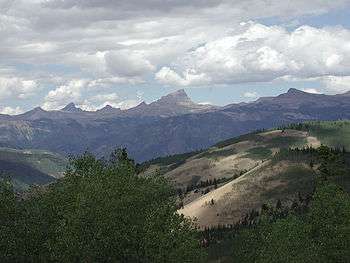
Uncompahgre Peak (![]() i/ənkəmˈpɑːɡreɪ/) is the sixth highest summit of the Rocky Mountains of North America and the U.S. state of Colorado. The prominent 14,321-foot (4365.0 m) fourteener is the highest summit of the San Juan Mountains and the highest point in the drainage basin of the Colorado River and the Gulf of California. It is located in the Uncompahgre Wilderness in the northern San Juans, in northern Hinsdale County approximately 7 miles (11 km) west of the town of Lake City.
i/ənkəmˈpɑːɡreɪ/) is the sixth highest summit of the Rocky Mountains of North America and the U.S. state of Colorado. The prominent 14,321-foot (4365.0 m) fourteener is the highest summit of the San Juan Mountains and the highest point in the drainage basin of the Colorado River and the Gulf of California. It is located in the Uncompahgre Wilderness in the northern San Juans, in northern Hinsdale County approximately 7 miles (11 km) west of the town of Lake City.
Uncompahgre Peak has a broad summit plateau, rising about 1,500 ft (500 m) above the broad surrounding alpine basins. The south, east and west sides are not particularly steep, but the north face boasts a 700 ft (210 m) cliff. Like all peaks in the San Juan Mountains, Uncompahgre is of volcanic origin, but is not a volcano. The rock is of poor quality for climbing, precluding an ascent of the north face.
The most popular route for climbing Uncompahgre Peak is Uncompahgre National Forest Service Trail Number 239, which starts from the end of the Nellie Creek Road, east-southeast of the peak. The Nellie Creek Road is a four wheel drive road accessed from the Henson Creek Road, about 4 miles (6.4 km) west of Lake City. The trail to the summit is a strenuous hike rising 2,919 ft (890 m) in elevation in about 3.5 mi (6 km). It accesses the summit in a winding ascent, starting from the east, passing over a south-trending ridge, and finishing on the west slopes of the summit plateau.[4]
The peak's name comes from the Ute word Uncompaghre, which loosely translates to "dirty water" or "red water spring" and is likely a reference to the many hot springs in the vicinity of Ouray, Colorado.[lower-alpha 1]
Historical names
- Unca-pah-gre Mountain
- Uncompahgre Mountain
- Uncompahgre Peak – 1907 [3]
See also
References
- 1 2 "UNCOMPAHGRE". NGS data sheet. U.S. National Geodetic Survey. Retrieved January 2, 2016.
- 1 2 3 4 "Uncompahgre Peak, Colorado". Peakbagger.com. Retrieved January 2, 2016.
- 1 2 "Uncompahgre Peak". Geographic Names Information System. United States Geological Survey. Retrieved November 14, 2014.
- ↑ Louis W. Dawson II. Dawson's Guide to Colorado's Fourteeners, Volume 2. Blue Clover Press. pp. 115–126. ISBN 0-9628867-2-6.
- ↑ Jarom McDonald (ed.). "The itinerary and diary of Francisco Atanasio Domínguez and Francisco Silvestre Vélez de Escalante". Maryland Institute for Technology in the Humanities. Retrieved 2013-01-27.
Notes
- ↑ In the journal of Francisco Silvestre Vélez de Escalante's 1776 expedition[5] the author states that the Native American name for the Uncompahgre River was Ancapagari, which translated to Spanish as Laguna Colorado and referred to a hot, bad tasting, red lake from which its waters came. The Spanish name for the river at that time was Rio de San Francisco, apparently so named by explorer Juan Maria de Rivera on one of his two earlier expeditions (1761 and 1765).
External links
- Uncompahgre Peak on 14ers.com
- Photo Journal of a Trip up Uncompahgre
- Topographic map
- Uncompahgre Peak on Distantpeak.com
- Uncompahgre Peak on Summitpost
