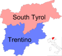
Trentino
| Autonomous Province of Trento Provincia autonoma di Trento | ||
|---|---|---|
| Autonomous Province | ||
| ||
 Map highlighting the location of the province of Trentino in Italy | ||
| Country |
| |
| Region | Trentino-Alto Adige/Südtirol | |
| Capital(s) | Trento | |
| Comuni | 217 | |
| Government | ||
| • Governor | Ugo Rossi (PATT—PD) | |
| Area | ||
| • Total | 6,212 km2 (2,398 sq mi) | |
| Population (2012) | ||
| • Total | 534,405 | |
| • Density | 86/km2 (220/sq mi) | |
| Time zone | CET (UTC+1) | |
| • Summer (DST) | CEST (UTC+2) | |
| Postal code | 38100 | |
| Telephone prefix | 0461, 0462, 0463, 0464, 0465 | |
| Vehicle registration | TN | |
| ISTAT | 022 | |

The Trentino or autonomous province of Trento is an autonomous province of Italy, in the country's far north. Trentino is, along with South Tyrol, one of the two provinces making up the region of Trentino-Alto Adige/Südtirol, which is designated an autonomous region under the constitution.[1] The province is divided into 178 comuni (municipalities).[2] Its capital is the city of Trento, historically known in English as Trent. The province covers an area of more than 6,000 km2 (2,300 sq mi), with a total population of about 500,000. Trentino is renowned for its mountains, such as the Dolomites, which are part of the Alps.
Etymology
The province is generally known as Trentino.[3][4][5][6][7][8][9][10] The name derives from Trento, the capital city of the province, which was also known historically as Trent in English. Originally, the term was used by the local population only to refer to the city and its immediate surroundings. Under former Austrian rule, which started in the XIX century (previously Trentino was ruled by the local bishop), the common German name for the region was Südtirol,[11] meaning South Tyrol with reference to its geographic position as the Southern part of Tyrol, Welschtirol or Welschsüdtirol, meaning Italian Tyrol or Italian South Tyrol.
The corresponding Italian terms were Tirolo meridionale, that was historically used to describe the wider southern part of the County of Tyrol, specifically Trentino and sometimes also today's South Tyrol,[12][13][14] or Tirolo italiano. In its wider sense, Trentino was first used around 1848 in an article by a member of the Frankfurt National Assembly; it became a popular term among leftist intellectual circles in Austria.[15]
Since the new 1972 autonomous status, the administrative name of the province is Autonomous Province of Trento (Italian: Provincia autonoma di Trento, German: Autonome Provinz Trient).[16] The German historical name Südtirol was assigned to the province of Bolzano.
History

The history of Trentino begins in the mid-Stone Age. The valleys of what is now Trentino were already inhabited by man, the main settlements being in the valley of the Adige River, thanks to its milder climate.
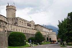
In the early Middle Ages, this area was included within the Kingdom of Italy and the March of Verona. In 1027, the Bishopric of Trent was established as a State of the Holy Roman Empire by Emperor Conrad II. It was an ecclesiastical territory, roughly corresponding to the present-day Trentino, ruled by the Prince-Bishops of Trent.
The Council of Trent, held in three major sessions from 1545 to 1563, with the first at Trent, was one of the important councils in the history of the Roman Catholic Church. It was an articulation of Catholic doctrine in response to the Protestant Reformation, and specified doctrine on salvation, the sacraments, and the Biblical canon.
After the Napoleonic Wars of the early nineteenth century, the bishopric was secularised and absorbed into the Austrian County of Tyrol. It was ruled by the House of Habsburg-Lorraine. The region was the location of heavy fighting during World War I, as it was directly on the front lines between Austria-Hungary and Italy.[18] Trentino remained a part of Austria-Hungary until after the end of the war in 1919. It was annexed by Italy in the Treaty of Saint-Germain.
After World War II, the Italian and Austrian Foreign Ministers signed the Gruber-De Gasperi Agreement, creating the autonomous region of Trentino-South Tyrol, consisting of the autonomous provinces of Trentino and South Tyrol. Since this treaty, Trentino enjoys considerable autonomy from the Italian central government in Rome. It has its own elected government and legislative assembly.
In 1996, the Euroregion Tyrol-South Tyrol-Trentino was formed between the Austrian state of Tyrol and the Italian provinces of South Tyrol and Trentino. The boundaries of the association correspond to the old County of Tyrol. The aim is to promote regional peace, understanding and cooperation in many areas. The region's assemblies meet together as one on various occasions and have set up a common liaison office to the European Union in Brussels.
Geography
Trentino is a mountainous region. The Adige river flows through central Trentino in a valley named after the river. The principal towns of Trentino lay in the Adige Valley, which has been a historical passage connecting Italy with Northern Europe. Among other important valleys are Non Valley, known for its apple production, Sole Valley, Giudicarie, which has been historically connected by Trento and Brescia, Fiemme and Fassa, Lagarina, Mocheni, Sugana Valley and many others.
The province has an area of 6,214 km2 (2,399 sq mi), and a total population of 524,826 (2010). There are 217 comuni (singular: comune), in the province.[19]
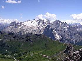
The Marmolada, at 3,343 m (10,968 ft) above sea level, is the highest mountain in the Dolomites. The glacier on the Marmolada is also a landmark. Other high mountains include the Monte Baldo, Carè Alto, Cermis, Crozzon di Brenta, Hintere Eggenspitze, Latemar, Paganella, Piz Boè, Presanella, Punta San Matteo and Vezzana.
Politics
The 1972 second Statute of Autonomy for Trentino-Alto Adige/Südtirol devolved most legislative and executive competences from the regional level to the provincial level, creating de facto two separate regions. Administratively, the province enjoys a large degree of autonomy in the following sectors: health, education, welfare and transport infrastructure. The provincial council comprises 35 members, one of whom must by law be drawn from the Ladin minority.
In the last elections in 2013, the strongest party became the Democratic Party (Partito Democratico del Trentino) with 9 deputies, Trentino Tyrolean Autonomist Party (8), Union for Trentino (5), Lega Nord Trentino (2), Forza Italia (1), Five Stars Movement (1), Trentino Project (1), Ladin Autonomist Union (1), Civic Trentino (1), Administer Trentino (1), with one independent.
The executive powers are attributed to the provincial government (Italian: Giunta Provinciale), headed by the governor (Presidente). Since 2013 the governor is Ugo Rossi of the leftist Trentino Tyrolean Autonomist Party party. The president of the provincial council alternates with the governor of South Tyrol as president of the Trentino-South Tyrol region. The regional government has its seat in the former Hotel Imperial in Trent.
The Ladin community has one reserved seat in the provincial assembly and is thereby guaranteed political representation.
Administration
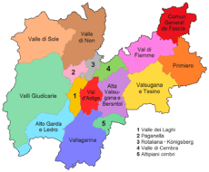
Due the division of the province into the 217 municipalities (Comuni/Gemeinden), often of small or even tiny size, in the late 1970s, eleven larger units called districts (comprensori) were introduced. The municipalities forming a district elect the council of it. However, this tier of government has provoked criticism, and, in 2006, a reform created fifteen more homogenous "Valley Communities" (comunità di valle, Talgemeinden) and one territory including the municipalities of Trento, Cimone, Aldeno and Garniga Terme (see Municipalities of Trentino).

| # | Name | Municipalities | Inhabitants | Capital | Map |
|---|---|---|---|---|---|
| 1 | Comunità territoriale della Val di Fiemme | 11 | 18,567 | Cavalese | |
| 2 | Comunità di Primiero | 8 | 9,836 | Tonadico | |
| 3 | Comunità Valsugana e Tesino | 21 | 25,694 | Borgo Valsugana | |
| 4 | Comunità Alta Valsugana e Bersntol | 18 | 45,228 | Pergine Valsugana | |
| 5 | Comunità della Valle di Cembra | 11 | 10,854 | Faver | |
| 6 | Comunità della Val di Non | 38 | 37,143 | Cles | |
| 7 | Comunità della Valle di Sole | 14 | 15,020 | Malè | |
| 8 | Comunità delle Giudicarie | 39 | 35,647 | Tione di Trento | |
| 9 | Comunità Alto Garda e Ledro | 7 | 42,955 | Riva del Garda | |
| 10 | Comunità della Vallagarina | 17 | 78,482 | Rovereto | |
| 11 | Comun General de Fascia | 7 | 9,195 | Pozza di Fassa | |
| 12 | Magnifica Comunità degli Altipiani Cimbri | 3 | 4,442 | Lavarone | |
| 13 | Comunità Rotaliana-Königsberg | 8 | 25,953 | Mezzocorona | |
| 14 | Comunità della Paganella | 5 | 4,731 | Andalo | |
| 15 | Val d'Adige territory | 4 | 110,061 | none | |
| 16 | Comunità della Valle dei Laghi | 6 | 9,349 | Vezzano | |
As of 2009, the only municipalities with a population over 20,000 were Trento, Rovereto, and Pergine Valsugana.
Economy
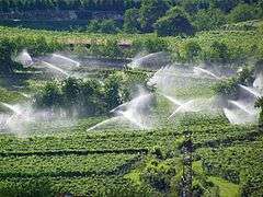

Despite the overwhelmingly mountainous nature of the territory, agriculture remains important. Farms often join together to form larger cooperatives. The most important produce comprises: apples (50% of national production, together with South Tyrol) and other fruit, vegetables (mainly in the Val di Gresta) and grape: important especially for its quality, the latter is used for the production of dry and sparkling wines.
In January 2008, the Edmund Mach Foundation was established to promote research, training and services in the agricultural, agri-food and environmental fields.
The main industries, often small- and medium-sized, are concentrated in Valsugana, Vallagarina and the Adige Valleys. Sectors include textiles, mechanics, wood and paper productions. Also important is the production of hydro-electric energy.
Tourism is the mainstay of the provincial economy. The main resorts include: Madonna di Campiglio, San Martino di Castrozza, Fiera di Primiero, Canazei, Moena, Cavalese, Folgaria, Folgarida-Marilleva, Riva del Garda and Levico Terme, Comano Terme and Roncegno, these last three being renowned thermal stations.
Transport

The Trentino province is crossed by the main road and rail connections between Italy and Germany. These include the Brenner A22 motorway and road which passes through the Etsch/Adige Valley. A regional project of switching much of the road traffic to railways is currently under consideration.
The province has two more railways: the Valsugana Line, connecting Trento to Venice and the Trento-Malè-Marilleva railway between Trento and Malè.
Demographics
In 2012 the population of Trentino was 534,405. The average population density was around 86/km2 (220/sq mi). The highest concentration of population is located around the capital city of Trent, and the southern parts. The whole region is divided up into 217 municipalities. The majority of the Trentino population is Italian-speaking with its local dialects.
Languages
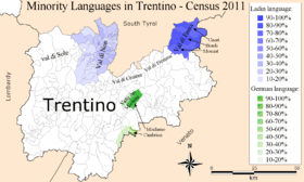
Census-data per municipality 2011
The region is also home to three other indigenous linguistic minorities, which are Ladin, Mócheno and Cimbrian. All three groups are protected by regional and provincial laws, statutes, and regulations.
After World War II and the devolution of power to regional authorities, a change in policy slowly began, which gained momentum in the 1990s. Since then a number of far-reaching laws and regulations have been passed and implemented, that protect and promote the use of these three languages and the unique cultural heritage and identity. This has for example been extended to school curricula in the regional languages and street signs becoming bilingual. All three minorities have their own cultural institute which were decreed by national law and receive state funds. The purpose of these cultural institutes is to safeguard and promote the respective culture and languages.
The Ladin minority is found in the Fassa Valley, in the municipalities of Canazei (Cianacei), Campitello di Fassa (Ciampedèl), Mazzin (Mazin), Moena, Poza, Soraga and Vigo di Fassa (Vich). In the census of 2001, 16,462 inhabitants of Trentino declared Ladin as their native language,.[20]
Mócheno is still spoken in the municipalities of Frassilongo (Garait), Palù del Fersina (Palai en Bersntol) and Fierozzo (Vlarötz), while the Cimbrian language is spoken in Luserna (Lusérn).[1] The 2001 census found there were 2,276 native Mócheno and 882 Cimbrian speakers.[20] The linguistic breakdown according to the census of 2001 is:[21]
| Language | Number | Percentage |
|---|---|---|
| Italian | 457,397 | 95.8 |
| Ladin | 16,462 | 3.5 |
| Mócheno | 2,276 | 0.5 |
| Cimbrian | 882 | 0.2 |
| Total | 477,017 | 100 |
The Nones language hails from the Non Valley and is considered by some linguists a variant of Ladin. Estimates range up to 30,000 speakers. The Solandro language is also under debate as to whether it is a dialect of Ladin or a separate language. Native speakers are mainly found in the Sole Valley and are estimated to be up to 15,000. Both idioms are alternatively considered as dialects within the range of Gallo-Romance languages. There is no official census to date that has Nones and Solandro as officially distinct languages. The total number of Ladin speakers in the census of 2001 exceeds the population of around 7,500 in the Fascia Valley. A number of Nones and Solandro speakers identified as Ladin speakers, while others chose not to exercise that option due to the disagreement whether or not their languages are Ladin or a separate idiom.
Culture
Sports
The region offers many opportunities for mountain climbing and trekking and winter sports. Important winter events are the world championships organised by the International Ski Federation (FSI) such as the Nordic ski 1991 and 2003, snowboarding 2001 and freestyle ski championship 2007, as well as the Adamello Ski Raid and Marcialonga.
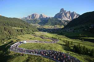
During the spring and summer, cycling is a big event in the region, such as the Giro del Trentino and Maratona dles Dolomites over the mountain passes. Cross country racing such as the Cross della Vallagarina and the 10-kilometre road running competition Giro al Sas also take place.
Association football is a popular ball sport in Trentino. Teams within the region are U.S. Alta Vallagarina, A.C. Mezzocorona, A.S.D. Porfido Albiano and Trento Calcio 1921.
The Trentino Volley is a successful regional volleyball team, while Aquila Trento is a successful basketball team in the Italian top league.
See also
References
- 1 2 "Special Statute for Trentino-Alto Adige" (DOC). Province of Trento. Retrieved 2009-02-11.
- ↑ "Province Statistics". Italian institute of statistics (Istat). Retrieved 2007-07-06.
- ↑ "Gerenza Trentino". SETA S.p.A. 2011. Retrieved 2011-04-06.
- ↑ Trentino at Google Books
- ↑ Trentino at Google Books
- ↑ Rifugi e bivacchi in Trentino at Google Books
- ↑ Castelli e torri in Trentino at Google Books
- ↑ Guida ai parchi gioco del Trentino at Google Books
- ↑ South Tyrol and Trentino Geocenter Euro Map at Google Books
- ↑ lecce (April 19, 2001), "Why old Italians like a list", The Economist, London
- ↑ among many: Karl Müller, An der Kampffront in Südtirol: Kriegsbriefe eines neutralen Offizeirs, Velhagen & Klasing, 1916: Das politische und militärische Ziel des Feldzugs der Italiener im Südtirol ist die befestigte Stadt Trient = The political and military objective of the Italian campaign in South Tyrol was the fortified city of Trento.
- ↑ Flora del Tirolo meridionale: ossia descrizione delle specie fanerogame che crescono spontanee sopra il suolo Trentino e nelle terre adjacenti comprese fra la catena delle Alpi Retiche sino al confini del Lombardo-Veneto loro proprietà ec. ec. at Google Books
- ↑ Erpetologia delle provincie Venete e del Tirolo meridionale at Google Books
- ↑ Repertorio universale della legislazione pel regno d'Italia dell' anno 1802, p. 420, at Google Books
- ↑ Ettore Tolomei - Der Totengräber Süd-Tirols
- ↑ Official Journals of the Provincia autonoma di Trento/Autonome Provinz Trient: No. 1 (2002), No. 17 (2003), No. 23 (2003), No. 39 (2003), No. 45 (2006) No. 20 (2007) and No. 25 (2007)
- ↑ Excluding Cortina, Colle Santa Lucia, Livinallongo, Pedemonte, Magasa and Valvestino.
- ↑ "The Trentino Campaign of 1916". historicaleye.com. Retrieved 2011-04-05.
- ↑ Province: Trento - Total Resident Population on 1st January 2010 by sex and marital status, ISTAT data.
- 1 2 "Tav. I.5 - Appartenenza alla popolazione di lingua ladina, mochena e cimbra, per comune di area di residenza (Censimento 2001)" (PDF). Annuario Statistico 2006 (in Italian). Autonomous Province of Trento. 2007. Retrieved 2011-05-12.
- ↑ "Trentino in figures" (PDF). Table 9 - Declarations of which language group belong to/affiliated to - Population Census 2001. Retrieved 2011-05-14.
External links
![]() Media related to Trentino at Wikimedia Commons
Media related to Trentino at Wikimedia Commons
| Provinces | |
|---|---|
| Politics and government | |
Categories | |

| |||
Coordinates: 46°26′44″N 11°10′23″E / 46.44556°N 11.17306°E