Puye Cliff Dwellings
|
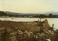
Puye Ruins | |
|
Entrances to the dwellings | |
  | |
| Location | Rio Arriba County, New Mexico, USA |
|---|---|
| Nearest city | Española, New Mexico |
| Built | 1250 |
| NRHP Reference # | 66000481[1] |
| Significant dates | |
| Added to NRHP | October 15, 1966 |
| Designated NHL | May 23, 1966[2] |

The Puye Cliff Dwellings are the ruins of an abandoned pueblo, located in Santa Clara Canyon on Santa Clara Pueblo land near Española, New Mexico. The site was declared a National Historic Landmark in 1966.
Ancient pueblo dwellings
Between 900 and 1580, up to 1500 pueblo Indians lived in the area where they hunted game and cultivated food. Native peoples first settled in the area in the late 10th century of the Pueblo II Era, living in dispersed farmstead dwellings at the east side of the Jemez Mountains. Their settlements increased and changed over time in the Pueblo III Era, when they lived in larger, concentrated villages of Otowi, Puye, Shufinne, Tsankawi, Tsirege, and Tyuonyi.[3]
The Puye Cliffs complex, the largest complex on the Pajarito Plateau, includes two levels of cliff-dwellings and surface and cave dwellings. The two levels of cliff dwellings, the mesa top and reconstructed 'Community House' are accessed by paths and about twelve stairways and ladders cut into the side of the cliff. One level of cliff dwellings is over 1 mile (1.6 km) long and the second is about 2,100 feet (640 m) long.[3][4]
The dwellings were carved out soft of volcanic tuff on about a 200 feet (61 m) cliff ridge. The rock is relatively soft and can be excavated using wooden tools. The cliff dwellings held about 740 rooms and ruins at the base of the cliff that likely held additional dwellings.[3][4] On top of the mesa are cave dwellings of the Pueblo II Era around which a multi-storied puebloan village was built. The south portion of the complex had 173 rooms on the ground floor. The total number of rooms is not known, but would include rooms on the northern side of the complex and the upper levels. In the center of the complex was a large plaza.[3]
About 1580 (after the end of the Pueblo IV Era) drought finally forced the villagers to leave for locations nearer to the Rio Grande valley. Present day inhabitants of Santa Clara Pueblo, some 10 miles (16 km) to the east, are descendants of the Puye.[3] The American Indians living in pueblo in northern New Mexico traditionally speak the Tewa language.[3] The Tewa name 'Puye' can be translated as 'pueblo ruin where the rabbits assemble or meet'.[5]
In 1907 Edgar Hewitt, with the Southwest Society of the Archeological Institute of America, excavated Puye Cliffs. It was the first systematic excavation of a prehistoric pueblo in the Rio Grande valley.[3]
 Kiva and ruins on top of mesa
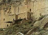 Cliff dwellings
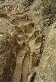 Steps, worn into the rock
Recent history
The cliff dwellings were declared a National Historic Landmark in 1966, under the name of "Puye Ruins."[2][6]
Established in the late 1200s or early 1300s and abandoned by about 1600, this is among the largest of the prehistoric Indian settlements on the Pajarito Plateau, showing a variety of architectural forms and building techniques. It is located on the Santa Clara Indian Reservation.[2]
In 2000, a planned burn of trees in Bandelier National Monument burned out of control. The resulting wildfire, known as the Cerro Grande Fire, eventually claimed 46,925 acres (189.90 km2), some 250 houses in Los Alamos, and devastated Santa Clara Canyon. Puye Cliff Dwellings site has recently (2009) been reopened to the public. Current information can be obtained from Santa Clara Pueblo.[7]
Tours can be scheduled to explore the cliffs and learn of their history.
See also
References
- ↑ National Park Service (2009-03-13). "National Register Information System". National Register of Historic Places. National Park Service.
- 1 2 3 "Puye Ruins". National Historic Landmark summary listing. National Park Service. Retrieved 2008-06-11.
- 1 2 3 4 5 6 7 Puye Cliff Dwellings History. Puye Cliffs. Retrieved 10-14-2011.
- 1 2 Puye Cliff Dwellings - Ancestral Home of the Santa Clara Indians. Legends of America. 2003-2011. Retrieved 10-14-2011.
- ↑ Harrington, John Peabody. (1916) The Ethnogeography of the Tewa Indians. Washington: Government Printing Office. p. 262.
- ↑ Note: A National Register of Historic Places Inventory-Nomination document should be available upon request from the National Park Service for this site, but it appears not to be available on-line from the NPS Focus search site.
- ↑ See Santa Fe New Mexican article about Santa Clara Canyon (Accessed 29 May 2006).
External links
| Wikimedia Commons has media related to Puye Cliff Dwellings. |
- Puye Cliff Dwellings
- Map and short guide showing how to find Puye
- Puye Ruins National Historic Landmarks Program
- Pictures of the cliff dwellings
Coordinates: 35°58′32″N 106°13′39″W / 35.97556°N 106.22750°W
| Topics | |
|---|---|
| Lists by states |
|
| Lists by insular areas | |
| Lists by associated states | |
| Other areas | |
| |