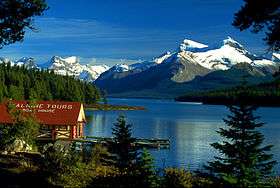
Queen Elizabeth Ranges
| Queen Elizabeth Ranges | |
|---|---|
 Seen from Maligne lake | |
| Highest point | |
| Peak | Mount Unwin |
| Elevation | 3,268 m (10,722 ft) |
| Coordinates | 52°36′36″N 117°31′41.9″W / 52.61000°N 117.528306°WCoordinates: 52°36′36″N 117°31′41.9″W / 52.61000°N 117.528306°W |
| Geography | |
| Country | Canada |
| Province | Alberta |
| Parent range | Canadian Rockies |
The Queen Elizabeth Ranges is a group of mountain ranges in the Canadian Rockies on the southeastern side of Jasper National Park, Canada. The northern end of the ranges begins east of Medicine Lake and extends in a southeasterly direction past the southern shore of Maligne Lake. The group was named in 1953 to celebrate the coronation of Queen Elizabeth II as Canada's sovereign.[1]
These ranges include the following mountains and peaks:[1]
| Mountain/Peak | metres | feet |
|---|---|---|
| Mount Unwin | 3,268 | 10,722 |
| Mount Charlton | 3,217 | 10,555 |
| Mount Mary Vaux | 3,201 | 10,502 |
| Coronet Mountain | 3,152 | 10,342 |
| Llysfran Peak | 3,141 | 10,306 |
| Mount Moffat | 3,090 | 10,138 |
| Samson Peak | 3,081 | 10,109 |
| Mount Paul | 2,805 | 9,203 |
| Leah Peak | 2,801 | 9,190 |
| Opal Peak | 2,800 | 9,187 |
| Mount Julian | 2,760 | 9,056 |
| Helmet Mountain | 2,612 | 8,570 |
References
- 1 2 "Queen Elizabeth Ranges". Peakfinder. Retrieved 2004-11-26.
This article is issued from Wikipedia - version of the 3/7/2016. The text is available under the Creative Commons Attribution/Share Alike but additional terms may apply for the media files.