Muskwa Ranges
| Muskwa Ranges | |
|---|---|
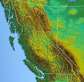 Location map of Muskwa Ranges | |
| Highest point | |
| Peak | Ulysses Mountain |
| Elevation | 3,024 m (9,921 ft) |
| Dimensions | |
| Area | 66,987 km2 (25,864 sq mi) |
| Geography | |
| Country | Canada |
| Province | British Columbia |
| Parent range | Canadian Rockies |
The Muskwa Ranges are a group of mountain ranges in northern British Columbia, Canada. They are part of the Northern Rockies section of the Rocky Mountains and are bounded on their west by the Rocky Mountain Trench and on their east by the Rocky Mountain Foothills. They are delimited on the north by the Liard River and on the south by the Peace Reach of the Lake Williston reservoir (formerly the Peace River), south of which the next major grouping of the Rockies is the Hart Ranges.
The Muskwa Ranges cover a surface of 97,388 square kilometres (37,602 sq mi) and stretch for 424 kilometres (263 mi) from north to south.[1]
Mountains and peaks
- Ulysses Mountain- 3,024 m (9,921 ft)
- Mount Sylvia- 2,940 m (9,646 ft)
- Mount Lloyd George- 2,938 m (9,639 ft)
- Great Rock Peak- 2,929 m (9,610 ft)
- Mount Roosevelt- 2,814 m (9,232 ft)
- Great Snow Mountain- 2,813 m (9,229 ft)
- Mount Peck- 2,807 m (9,209 ft)
- Churchill Peak- 2,770 m (9,088 ft)
- Yedhe Mountain- 2,717 m (8,914 ft)
- Gataga Peak- 2,533 m (8,310 ft)
Sub-ranges
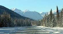
The Alaska Highway crossing the Muskwa Ranges
- Allied Leaders Range
- Akie Range
- Battle of Britain Range
- Deserters Range
- Gataga Ranges
- Italy Range
- Rabbit Plateau
- Sentinel Range
- Stone Range
- Terminal Range
- Tochieka Range
- Tower of London Range
- Truncate Range
See also
References
- ↑ Peakbagger - Muskwa Ranges
This article is issued from Wikipedia - version of the 4/13/2014. The text is available under the Creative Commons Attribution/Share Alike but additional terms may apply for the media files.