Rarh region
| Rarh Region রাঢ় | |
|---|---|
| Geographical/Historical Area | |
| Coordinates: IN 11°0′45″N 78°9′36″E / 11.01250°N 78.16000°ECoordinates: IN 11°0′45″N 78°9′36″E / 11.01250°N 78.16000°E | |
| Country |
|
| Region | East India |
| Government | |
| • Body | Government of West Bengal, Government of Jharkhand |
| Area | |
| • Total | 377 km2 (146 sq mi) |
| Population (2001)[1] | |
| • Total | 15,700,000 (approx.) |
| • Density | 607/km2 (1,570/sq mi) |
| Languages | |
| • Official | Bengali & Santhali |
| Time zone | IST (UTC+5:30) |
| Vehicle registration | WB-11,WB-12,WB-14,WB-15,WB-16,WB-18,WB-29,WB-30,WB-31,WB-32,WB-WB-33,WB-34,WB-36,WB-37,WB-38,WB-39,WB-40,WB-41,WB-42,WB-44,WB-53,WB-54,WB-55,WB-56,WB-57,WB-WB-58,WB-67,WB-68, |
| Major Cities | Asansol, Durgapur |
| Literacy | 62.61% |
| Civic agency | Government of West Bengal, Government of Jharkhanf |
Rarh region (Bengali: রাঢ়, Rāṛh) is a toponym for an area in the Indian subcontinent that lies between the Chota Nagpur Plateau on the West and the Ganges Delta on the East. Although the boundaries of the region have been defined differently according to various sources throughout history, today it is mainly coextensive with the state of West Bengal also comprising some portions of the state of Jharkhand and Bihar in India.[2][3][4]
The Rarh region historically has been known by many different names and has hosted numerous settlements throughout history. It is suggested that the Rarh region hosted an ancient civilisation also called Rarh and a powerful state, however much of its ancient history remains unknown.[3][4][5][6]
Different names and etymology
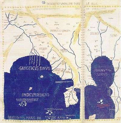
Different names of the region as endonyms are usually variations of the term Rāṛh. It is worth noting that the grapheme ঢ় /ṛh/ is basically the same as ঢ /ḑh/, the only difference being one dot under the ঢ and they belong to the same morphophoneme. The interchangeable variations Radha, Rarha, Ladha, Lara are observed in the oldest Jain book of codes Acaranga Sutra of the 6th century BC. Some other sources use the endonyms Lala, Rara and Lada. According to the linguist Sarkar the Chinese called Rarh as Lati, the Greek as Ganga Ridae and the Aryans as Rāṭṭha. Moreover, many Greek, Roman and Egyptian sources use the variations of Gangaridai, Gangaridae, Gangaritai and Gangaridum with the sense of a state, nation or civilisation which existed more or less in the same or a larger extent of Rarh. Megasthenes, Ptolemy, Strabo, Pliny, Arrian, Diodorus Siculus, Quintus Curtius Rufus and Plutarch all wrote about Gangaridae.[3][4][7][8]
The etymology of the word Rarh is not clear however there are many authors suggesting that it originates from a local language of Austroasiatic family. It could have originated from any of the following words of the Santali language; lar means "thread", rarh means "tune" and larh means "snake". And according to Sarkar, the word originates from Proto-Austroasiatic *Rāŗhā or *Rāŗho which means "land of red soil" or "land of laterite".[3][7]
The etymology of the word Gangaridae is also not clear. According to the historian Dr. Atul Sur, Pliny and Ptolemy it means Ganga-Ridai (Rarh of the Ganges – Ganges' Rarh). However, according to other scholars it might derive as Ganga-Hrd (land with Ganges in its heart), Ganga-Rashtra (State of the Ganges) or Gonda-Ridai (Land of the Gonds). Megasthenes call the people of Gangaridae as Gangarides. Diodorus Siculus describes Gangaridae as "a nation possessing the greatest number of elephants and the largest in size."[8]
Geography
Western parts of Rarh merging with the Chota Nagpur Plateau was historically called Vajjabhumi a definition demarcating it from the eastern part of Rarh which was called Subbhabhumi, Sumhabhumi or Suhmo. There are many descriptions of the geographical area called Rarh or Gangaridae, some being quite imprecise they are capable of indicating a very large area and some though being precise, differ in their descriptions. Most precise descriptions of Rarh seem coextensive with West Bengal. More imprecise descriptions denoting larger areas usually derive from Western sources describing Gangaridae. Some sources describe a smaller area while referring to Rarh as a geographical area and a larger description comes with Rarh defined as a geopolitical unit.[3][9][10]
According to the Encyclopædia Britannica, Rarh is mainly Murshidabad's surrounding region, a high, undulating continuation of the Chota Nagpur plateau to the West, and the Bagri, a fertile, low-lying alluvial tract, part of the Ganges (Ganga)-Brahmaputra delta, to the East.[2] Banglapedia says that Rarh consists of a large part of West Bengal.[4] And according to West Bengal Travel & Tourism Guide, the northeastern border of Rarh is located within Birbhum.[9]
Historically, a statement in Digvijayaprakasha locates Rarh as from the north of the Damodar River and to the west of Ganges in the south. Even though earliest written documents divides Rarh as West Rarh and East Rarh, later documents starting from the 9th and 10th century AD, divides it to Daksina Radha (Northern Rarh) and Uttara Radha (Southern Rarh). However, as inferred from later documents, this newer distinction (North/South) is not based on geography but two political states. Southern Rarh included different large settlements of the modern districts of Howrah, Hooghly and Burdwan in West Bengal, or considerable portions of West Bengal lying between the rivers Ajay and Damodar. The Ajay river is usually regarded as constituting the boundary line between Northern and Southern Rarh. Based on different epigraphic records, it is suggested that Northern Rarh included the western parts of the modern district of Murshidabad, the entire district of Birbhum, including some parts of Santhal Pargana, and the northern part of the Katwa sub-division of Burdwan district. There are many archaeological sites in many parts of Rarh, where studies are going on.[4]
Historian P. R. Sarkar, who has been doing research around most of those archaeological sites, gives a very detailed account of Rarh's geography, using the old geographical definitions of West/East Rarh. According to this definition:[3]

- East Rarh consists of roughly of the following districts:
- Western Murshidabad
- Northern Birbhum
- Eastern Burdwan (Bardhaman)
- Hooghly
- Howrah
- East Midnapore (Medinipur)
- Indas of Bankura district
- West Rarh consists of the following districts:
- Old Santhal Pargana district (today 6 districts: Godda, Deoghar, Dumka, Jamtara, Sahibganj and Pakur)
- Most parts of Birbhum
- Western Burdwan
- Bankura district except for Indas
- Purulia
- Dhanbad
- Most parts of Giridih
- Four block of Ranchi, namely Silli, Sonahatu, Bundu and Tamar
- Singhbhum
- Jhargram subdivision of West Midnapore
Rarh region is believed to be created from the soil from the Deccan plateau. Red coloured laterite soil is predominant.[3] West Rarh's Bagri river is a fertile, low-lying alluvial tract. Rice, jute, legumes, oilseeds, wheat, barley, and mangoes are the chief crops in the east; extensive mulberry cultivation is carried out in the west.[2]
The ancient snowcovored mountain peaks of Rarh gave birth to numerous rivers. These rivers, fed by melting snow flowed to the east and south east towards the ocean. The most notable rivers are Damodar, Ajay, Mayurakshi, Dwarakeswar, Shilai and Kasai. All the river originates from Chota Nagpur Plateau and flows towards east or south-east finally to meet the River Hooghly. The river Subarnarekha flows through some parts of the region and ends at the Bay of Bengal. In the past, some of the rivers were notorious for causing flood. With the construction of several dams, the floods have been somewhat controlled.[3]
Accounts on Rarh
A chronological listing of account on both concepts:
6th century BC, Ladha is mentioned in the oldest Jain book of codes Acaranga Sutra:[4]
- Mahavira travelled in the pathless country of 'Ladha' in Vajjabhumi and Subbhabhumi in the sixth century BC in trying to propagate religion. During this period the settlement was 'pathless and lawless' and its people treated Mahavira harshly.
6th century BC, Lala is mentioned by Dipavangsha and Mahavangsha:[4]
- Sri Lanka was colonised by Prince Vijaya who hailed from Simhapura in Lala.
From 9th till 16th century:[4]
- A Jain monk of Rara is mentioned in an inscription from Mathura.
- Radha's queen's imprisonment by Chandella is mentioned in the epigraphic records from Kajuraho.
- Radha is mentioned as being the ancestral settlement of Senas; in the Naihati Copper plate inscription of Vallalasena.
- Radha is mentioned as being a waterless, dry and woody region; in the Bhuvaneshvara inscription of Bhatta Bhavadeva.
- The division of Lada into North and South is mentioned in the Tirumulai rock inscription of Rajendra Chola. (11th century)
- The same division of Radha is also mentioned in the Gaonri Plates of Vakpati Munja (10th century), in Shridharacharya's Nyayakandali, in the Amareshvara Temple inscription of Mandhata (Nimar district in Madhya Pradesh), in Krsna Mishra's Prabodha-Chandrodaya and in Mukundarama's Chandimangal (16th century)
History
According to Acaranga Sutra, Mahavira travelled in 'Ladha' in Vajjabhumi and Subbhabhumi at a time (5th century BC) when the country was lawless and the people were harsh at him.
The Bhubaneswar inscription of Bhavadeva Bhatta records that "Raḍha was a waterless, dry and woody region".
Rakhaldas Bandyopadhyay, the famous Bengali historian says: "During Chandragupta Maurya's rule Gangaridae was independent like the Andhra kingdom and Gangaridae was joined with Kalinga(ancient Orissa)."[11] It is interesting that the description of the armed forces of Gangaridae and Calingae during the reign of Chandragupta Maurya as given by Megasthenes are identical (both possessed army of 60,000-foot-soldiers, 1,000 horsemen and 700 elephants).
Dipavangsha and Mahavangsha state that Sri Lanka was colonised by Vijaya Simha who hailed from Simhapura in 'Lala' (Rarh).
Outstanding personalities of Rarh
Rarh presented human society the first philosopher Maharishi Kapil who was born near Jahlda. Maharishi Patanjali who systematised yoga was born in Patun village in Burdwan. Kashiram Das from Siddhi village in Burdwan made the Mahabharata in lucid language accessible to the people and Krittivas Ojha did the same with the Ramayana. Others were born in Rarh or were by lineage from Rarh such as: Lochandas Thakur, Vrindavandas Thakur, Govindadas Thakur, Dvaja Chandidas, Dina Chandidas, Boru Chandidas, Ghanaram Chakravorty, Kavikankan Mukundaram Chakravorty, Bharatchandra Ray, Premendra Mitra, Sharatchandra, Tarashankar Bandopadhyay, the poet Jaydev, Nobel laureate Rabindranath Tagore, Anil Kumar Gain, Michael Madhusudan Dutta, Kazi Nazrul Islam, Satyen Dutta, Rajshekhar Basu (Parashuram), Shubhankar Das, Kashana, Jayanta Panigrahi, Ishwarchandra Vidyasagar, Satyendranath Bose, Rashbehari Bose, Prafulla Chandra Roy, Subhas Chandra Bose, Ramakrishna Paramahamsa, Swami Vivekananda, Shri Aurobindo, Raja Rammohan Roy, Kaliprasanna Singha, Ramprasad Sen, Keshab Chandra Sen, Akshay Kumar Datta, Devendranath Tagore, Dwarakanath Tagore, Thakur Shri Nityananda, Abanindranath Tagore, Gaganendranath Tagore, Thakur Krshnadas Kaviraj, Yamini Ray, Kaberi Gain, Ramkinkar Baij, Kalidasa and others.[3]
See also
References
- ↑ Census of India, 2001. Census Data Online, Population.
- 1 2 3 "Rarh". Encyclopædia Britannica. Retrieved 26 August 2012.
- 1 2 3 4 5 6 7 8 9 Sarkar, Shrii Prabhat Ranjan (2004). Ráŕh – The Cradle of Civilization. Ananda Marga Publications. OCLC 277280070.
- 1 2 3 4 5 6 7 8 Chattopadhyaya, Rupendra K (2012). "Radha2". In Islam, Sirajul; Jamal, Ahmed A. Banglapedia: National Encyclopedia of Bangladesh (Second ed.). Asiatic Society of Bangladesh.
- ↑ Majumdar, Dr. R. C. (1960). The Classical Accounts of India. Calcutta. pp. 103–128; 170–172; 198; 234.
- ↑ McCrindle, John W. (1901). Ancient India As Described in Classical Literature. Munshiram Manoharlal Publishers. p. 201. ISBN 8170690838.
- 1 2 "Bankura". RTBot – Real Time Information. Retrieved 26 August 2012.
- 1 2 "The Historic State of Gangaridai". Bangladesh.com. Retrieved 26 August 2012.
- 1 2 "Birbhum". West Bengal Travel & Tourism Guide. Retrieved 26 August 2012.
- ↑ "West Bengal". East India Birding. Retrieved 26 August 2012.
- ↑ "Bangalar Itihash" (History of Bengal) by Rakhaldas Bandyopadhyay V-I, p. 23 cited in Gangaridai.