Raritan Bayshore
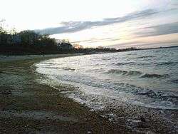
The Raritan Bayshore region of New Jersey is a subregion of the larger Jersey Shore. It is the area around Raritan Bay from The Brunswicks to Sandy Hook, in Monmouth and Middlesex counties, including the towns of New Brunswick, home of Rutgers University, Edison, Perth Amboy, Keyport, "Pearl of the Bayshore", Keansburg, and Highlands, New Jersey. It is the northernmost part of the Jersey Shore, located just south of New York City. At Keansburg is a traditional amusement park while at Sandy Hook are found ocean beaches. The Sadowski Parkway beach area in Perth Amboy, which lies at the mouth of the Raritan River, was deemed the "Riviera of New Jersey" by local government. In the last years many of the beaches on the Bayshore area have been rediscovered and upgraded as the quality of the water continues to improve.
Henry Hudson and the Half Moon
In September 1609, the Halve Maen, anchored along the shores of the Raritan Bay, and remained for five days to explore the estuary and establish contact with local Lenape people (who later become known as the Navesink and Raritan). Four his crew were sent up the Arthur Kill and to Newark Bay. Upon their return they were attacked and one of them, John Colman was fatally shot by arrow. Taken ashore to be buried, the spot was christened Coleman's Point.[1] The location Keansburg still bears the name.[2][3]
Popular Attractions
Popular attractions in the Bayshore area include Keansburg Amusement Park in Keansburg, Mount Mitchill in Atlantic Highlands, and Rutgers Gardens in North Brunswick. There are also beaches in both of The Amboys, Old Bridge, the Cliffwood Beach section of Aberdeen, Keyport, Union Beach, Keansburg, and Middletown. There are also non-commercial boardwalks in Perth Amboy and Keansburg
Bayshore Regional Strategic Plan
The Bayshore Regional Strategic Plan is an effort by nine municipalities in northern Monmouth County, New Jersey to reinvigorate the area's economy by emphasizing the traditional downtowns, dense residential neighborhoods, maritime history, and the natural beauty of the Raritan Bay coastline, especially along the Route 36 corridor along Sandy Hook Bay.
Municipalities participating in the effort are Aberdeen, Atlantic Highlands, Hazlet, Highlands, Keansburg, Keyport, Matawan, Middletown and Union Beach.
The Plan will be developed in collaboration with Monmouth County and the Region's nine municipalities as well as other stakeholders with an interest in the preservation, growth and redevelopment of the Bayshore area. Representatives from State agencies including the New Jersey Department of Transportation, New Jersey Department of Environmental Protection and the New Jersey Office of Smart Growth will be asked to participate in the effort.
In August 2006 the report was released, and Monmouth County was asked to vote to have the county planning board approve the plan the Bayshore organization has created.[4]


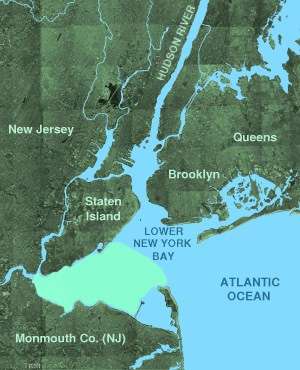
Sandy Hook Bay
Sandy Hook Bay is a triangular arm of the Raritan Bay, along the coast of northern New Jersey in the United States. It is formed along the south side of Lower New York Bay by Sandy Hook, a spit of land that protects the bay from the open Atlantic Ocean. The bay provides a sheltered marina for pleasure craft, as well as a harbor for the United States Coast Guard. It is fed by the Shrewsbury River estuary. It is bounded on the west side by the Naval Weapons Station Earle pier.
Nature, tourism, and recreation
The Henry Hudson Trail is a bicycling and hiking trail which runs parallel to the southern shore of Raritan Bay.
The Bayshore area is mostly flat areas of beach, with the exception of the hills between the Navesink River and Sandy Hook Bay. Mount Mitchill, a 266-foot (81 m) hill in Atlantic Highlands, is the highest.[5] To the east of Mt. Mitchill are the Twin Lights Lighthouse of Highlands, with unobstructed views of Sandy Hook and the New York City skyline. Hartshorne Woods Park is also located in the Monmouth Hills to the south on the banks of the Navesink River.
The Gateway National Recreation Area Sandy Hook Unit on the barrier peninsula includes two park sites:
- Fort Hancock served as part of the harbor's coastal defense system from 1895 until 1974 and contains 100 historic buildings and fortifications.[6]
- Sandy Hook contains seven beaches, including Gunnison Beach, a "nude beach" by custom, as well as salt marshes and a maritime holly forest. Fishing and using hand-launched vessels are popular here.
The New Jersey Coastal Heritage Trail Route[7] and Cheesequake State Park are also here.
Lighthouses
- Chapel Hill Rear Range Light, Sandy Hook Bay (deactivated 1957)
- Conover Beacon, Leonardo
- Great Beds Light, South Amboy
- Navesink Twin Lights, Highlands
- Sandy Hook Lighthouse, Sandy Hook.
Transportation
Ferry service
Ferries to New York City and Exchange Place (Jersey City) travel across the Lower New York Bay and enter the harbor at The Narrows, a trip that take approximately 40 minutes.
SeaStreak routes connect the towns of Atlantic Highlands and Highlands to the East River at Pier 11 at Wall Street and East 34th Street Ferry Landing in New York City.
The Belford ferry slip is New York Waterway's Raritan Bayshore terminal with service to Paulus Hook Ferry Terminal in Jersey City and Wall Street-Pier 11 and West Midtown Ferry Terminal in New York City.[8]
From Memorial Day weekend through Labor Day weekend, service is also provided to the public beaches in Sandy Hook a few times each day by SeaStreak.
North Jersey Coast Line
NJ Transit's North Jersey Coast Line crosses the Raritan River on River Draw between Perth Amboy and South Amboy continuing south to Aberdeen-Matawan, Hazlet, and Middletown.
Bus
- NJT bus 834 travels to the Red Bank bus terminal along Route 36.[9]
- Academy Bus runs regular service in to points in New Jersey and New York City
See also
Footnotes
- ↑ Sandler, Corey (2007), Henry Hudson Dreams and Obsession, Citadel Press, ISBN 978-0-8065-2739-0
- ↑ Keansburg Historical Society, accessed April 10, 2007.
- ↑ Roberts, Sam (September 4, 2009). "New York's Coldest Case: A Murder 400 Years Old". New York Times. Retrieved 2009-09-04.
- ↑ Bowes, Karen E. (August 30, 2006). "Blueprint complete for improved Rt. 36: County to vote on Bayshore Regional Strategic Plan". Holmdel Independent. Retrieved 2011-07-20.
- ↑ Great Blue Hill at 635 feet (194 m) and Todt Hill on nearby Staten Island at 410 feet (120 m) are higher than Mitchill
- ↑ Fort Hancock (National Parks of New York Harbor Conservancy)
- ↑ New Jersey Coastal Heritage Trail Route
- ↑ Monmouth County's Belford Ferry Terminal
- ↑ NJT bus 834 schedule
External links
- Bayshore Regional Strategic Plan
- Final Copy of the Bayshore Region Strategic Plan
- The Bayshore
- Henry Hudson Trail
- Henry Hudson Regional Alumni Association
- Hartshorne Woods Park
- Sandy Hook Bay Catamaran Club
Coordinates: 40°26′28″N 74°02′40″W / 40.441199°N 74.044418°W