Rozellville, Wisconsin
| Rozellville, Wisconsin | |
|---|---|
| Unincorporated community | |
|
Looking east at Rozellville on County C | |
 Rozellville, Wisconsin  Rozellville, Wisconsin | |
| Coordinates: 44°44′36″N 90°01′28″W / 44.74333°N 90.02444°WCoordinates: 44°44′36″N 90°01′28″W / 44.74333°N 90.02444°W | |
| Country | United States |
| State | Wisconsin |
| County | Marathon |
| Elevation | 1,260 ft (380 m) |
| Time zone | Central (CST) (UTC-6) |
| • Summer (DST) | CDT (UTC-5) |
| Area code(s) | 715 & 534 |
| GNIS feature ID | 1572702[1] |

Rozellville is an unincorporated community located in the town of Day, Marathon County, Wisconsin, United States. Located at the intersection of County Road M and County Road C, approximately 3 miles East of State Highway 97.[1]
Images
 Looking east at the Rozellville sign on County C
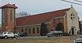 St. Andrew Catholic Church
References
Municipalities and communities of Marathon County, Wisconsin, United States | ||
|---|---|---|
| Cities | 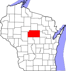 | |
| Villages | ||
| Towns |
| |
| CDPs | ||
| Unincorporated communities |
| |
| Ghost towns/ neighborhoods | ||
| Footnotes | ‡This populated place also has portions in an adjacent county or counties | |
This article is issued from Wikipedia - version of the 7/29/2016. The text is available under the Creative Commons Attribution/Share Alike but additional terms may apply for the media files.