Athens, Wisconsin
| Athens, Wisconsin | |
|---|---|
| Village | |
|
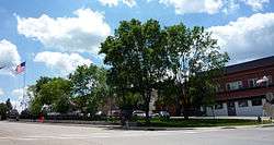
Downtown Athens | |
| Nickname(s): A-town | |
| Motto: A friendly town that bands together and works together as a community | |
 Location of Athens, Wisconsin | |
| Coordinates: 45°1′58″N 90°4′35″W / 45.03278°N 90.07639°WCoordinates: 45°1′58″N 90°4′35″W / 45.03278°N 90.07639°W | |
| Country | United States |
| State | Wisconsin |
| County | Marathon |
| Area[1] | |
| • Total | 2.46 sq mi (6.37 km2) |
| • Land | 2.46 sq mi (6.37 km2) |
| • Water | 0 sq mi (0 km2) |
| Elevation[2] | 1,401 ft (427 m) |
| Population (2010)[3] | |
| • Total | 1,105 |
| • Estimate (2012[4]) | 1,101 |
| • Density | 449.2/sq mi (173.4/km2) |
| Time zone | Central (CST) (UTC-6) |
| • Summer (DST) | CDT (UTC-5) |
| Zip Code | 54411 |
| Area code(s) | 715 & 534 |
| FIPS code | 55-03550[5] |
| GNIS feature ID | 1560994[2] |
| Website |
athenswis |

Athens is a village in Marathon County, Wisconsin, United States. The population was 1,105 at the 2010 census.[6] It is part of the Wausau, Wisconsin Metropolitan Statistical Area.
Geography
Athens is located at 45°1′58″N 90°4′35″W / 45.03278°N 90.07639°W (45.032641, -90.076442).[7] Athens is almost halfway between the Equator and North Pole, as well as almost halfway between the Prime Meridian and 180th meridian. The Athens area is primarily agricultural with a small industrial park on the south side of the village limits.
According to the United States Census Bureau, the village has a total area of 2.46 square miles (6.37 km2), all of it land.[1]
Demographics
| Historical population | |||
|---|---|---|---|
| Census | Pop. | %± | |
| 1910 | 904 | — | |
| 1920 | 940 | 4.0% | |
| 1930 | 936 | −0.4% | |
| 1940 | 856 | −8.5% | |
| 1950 | 823 | −3.9% | |
| 1960 | 770 | −6.4% | |
| 1970 | 856 | 11.2% | |
| 1980 | 988 | 15.4% | |
| 1990 | 951 | −3.7% | |
| 2000 | 1,095 | 15.1% | |
| 2010 | 1,105 | 0.9% | |
| Est. 2015 | 1,096 | [8] | −0.8% |
2010 census
As of the census[3] of 2010, there were 1,105 people, 471 households, and 298 families residing in the village. The population density was 449.2 inhabitants per square mile (173.4/km2). There were 503 housing units at an average density of 204.5 per square mile (79.0/km2). The racial makeup of the village was 96.2% White, 0.2% African American, 0.2% Native American, 0.2% Asian, 2.4% from other races, and 0.8% from two or more races. Hispanic or Latino of any race were 4.9% of the population.
There were 471 households of which 30.1% had children under the age of 18 living with them, 50.7% were married couples living together, 8.1% had a female householder with no husband present, 4.5% had a male householder with no wife present, and 36.7% were non-families. 30.1% of all households were made up of individuals and 14.4% had someone living alone who was 65 years of age or older. The average household size was 2.35 and the average family size was 2.96.
The median age in the village was 39.5 years. 24.7% of residents were under the age of 18; 7.6% were between the ages of 18 and 24; 25.7% were from 25 to 44; 24.3% were from 45 to 64; and 17.7% were 65 years of age or older. The gender makeup of the village was 51.0% male and 49.0% female.
2000 census
At the 2000 census,[5] there were 1,095 people, 443 households and 299 families residing in the village. The population density was 448.2 people per square mile (173.3/km²). There were 469 housing units at an average density of 192.0 per square mile (74.2/km²). The racial makeup of the village was 98.72% White, 0.09% Native American, 0.55% from other races, and 0.64% from two or more races. Hispanic or Latino of any race were 2.10% of the population.
There were 443 households of which 33.4% had children under the age of 18 living with them, 56.9% were married couples living together, 7.0% had a female householder with no husband present, and 32.5% were non-families. 29.1% of all households were made up of individuals and 16.9% had someone living alone who was 65 years of age or older. The average household size was 2.47 and the average family size was 3.08.
Age distribution was 26.8% under the age of 18, 8.5% from 18 to 24, 27.2% from 25 to 44, 19.3% from 45 to 64, and 18.3% who were 65 years of age or older. The median age was 36 years. For every 100 females there were 93.8 males. For every 100 females age 18 and over, there were 94.2 males.
The median household income was $39,286, and the median family income was $52,727. Males had a median income of $30,956 versus $22,167 for females. The per capita income for the village was $17,076. About 1.3% of families and 4.5% of the population were below the poverty line, including 0.7% of those under age 18 and 12.1% of those age 65 or over.
Athens Library
The Athens Library is part of the Marathon County Public Library (MCPL) and the Wisconsin Valley Library Service, a regional library system.[10] The library began in the early 1900s as a small collection of books in the Bloczynski Hotel. In 1926, the Athens Women's Club assumed management of the library, moving the collection to the Athens Bank.[11] The library moved again in 1941, to the Community Hall. In 1947, the Athens Library joined the Marathon County Library. In 1973, when the Marathon County Library and Wausau Public Library merged to form the Marathon County Public Library, the Athens Library became a branch of the MCPL.[11]
Education
The Athens School District is made up of three schools: Athens Elementary School, Athens Middle School, and Athens High School. The middle and high schools share the same building. The Athens School District belongs to the Marawood Conference. Its mascot is the Fighting Bluejay. There are two parochial schools in the community, Trinity Lutheran and St. Anthony's Catholic School.
Notable people
- Russ Decker, Wisconsin politician, was born in Athens.[12]
- Charles Winninger, notable character actor, was born in Athens.
References
- 1 2 "US Gazetteer files 2010". United States Census Bureau. Archived from the original on 2012-01-24. Retrieved 2012-11-18.
- 1 2 "US Board on Geographic Names". United States Geological Survey. 2007-10-25. Retrieved 2008-01-31.
- 1 2 "American FactFinder". United States Census Bureau. Retrieved 2012-11-18.
- ↑ "Population Estimates". United States Census Bureau. Archived from the original on 2013-06-17. Retrieved 2013-06-24.
- 1 2 "American FactFinder". United States Census Bureau. Archived from the original on 2013-09-11. Retrieved 2008-01-31.
- ↑ "Profile of General Population and Housing Characteristics: 2010 Demographic Profile Data (DP-1): Athens village, Wisconsin". U.S. Census Bureau, American Factfinder. Archived from the original on September 11, 2013. Retrieved September 7, 2012.
- ↑ "US Gazetteer files: 2010, 2000, and 1990". United States Census Bureau. 2011-02-12. Retrieved 2011-04-23.
- ↑ "Annual Estimates of the Resident Population for Incorporated Places: April 1, 2010 to July 1, 2015". Retrieved July 2, 2016.
- ↑ "Census of Population and Housing". Census.gov. Archived from the original on May 11, 2015. Retrieved June 4, 2015.
- ↑ http://pld.dpi.wi.gov/pld_wisysdir
- 1 2 http://www.mcpl.us/about/locations/?mcpl_loc=athens
- ↑ 'Wisconsin Blue Book 2009-2010,' Biographical Sketch of Russ Decker, pg. 76
External links
- Village of Athens official website
- Athens School District
- Marathon County Public Library - Athens Branch
Municipalities and communities of Marathon County, Wisconsin, United States | ||
|---|---|---|
| Cities | 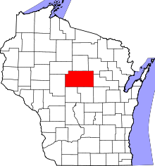 | |
| Villages | ||
| Towns |
| |
| CDPs | ||
| Unincorporated communities |
| |
| Ghost towns/ neighborhoods | ||
| Footnotes | ‡This populated place also has portions in an adjacent county or counties | |