Abbotsford, Wisconsin
| Abbotsford, Wisconsin | |
|---|---|
| City | |
|
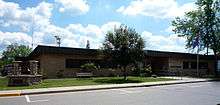
First Street, downtown Abbotsford | |
| Nickname(s): Wisconsin's First City | |
 Location of Abbotsford, Wisconsin | |
| Coordinates: 44°56′48″N 90°19′6″W / 44.94667°N 90.31833°WCoordinates: 44°56′48″N 90°19′6″W / 44.94667°N 90.31833°W | |
| Country | United States |
| State | Wisconsin |
| Counties | Clark, Marathon |
| Government | |
| • Mayor | Dale Rachu |
| Area[1] | |
| • Total | 2.71 sq mi (7.02 km2) |
| • Land | 2.71 sq mi (7.02 km2) |
| • Water | 0 sq mi (0 km2) |
| Elevation[2] | 1,407 ft (429 m) |
| Population (2010)[3] | |
| • Total | 2,310 |
| • Estimate (2012[4]) | 2,292 |
| • Density | 850/sq mi (330/km2) |
| Time zone | Central (CST) (UTC-6) |
| • Summer (DST) | CDT (UTC-5) |
| Area code(s) | 715 & 534 |
| FIPS code | 55-00100[5] |
| GNIS feature ID | 1560663[2] |
| Website |
ci |

Abbotsford is a city in Clark (mostly) and Marathon counties in the U.S. state of Wisconsin. It is part of the Wausau, Wisconsin Metropolitan Statistical Area. The population was 2,310 at the 2010 census.[6] Of this, 1,616 were in Clark County, and 694 were in Marathon County. Abbotsford is nicknamed "Wisconsin's First City" due to its alphabetical place on a list of Wisconsin cities.[7]
History
In 1872, the Wisconsin Central Railroad cleared its right of way through the forest which would become Abbotsford, heading north for Ashland. Rails were built through the town site in 1874. In 1879 the directors of the Wisconsin Central decided to build west from Colby to Chippewa Falls, to connect there with the Chippewa Falls & Western and ultimately St. Paul. However, they found that Colby Hill was not a good site for a junction and rail yard, so they instead planned the east-west line 2.5 miles north of Colby. The place was called Colby Junction from 1879 to 1880, then renamed for Edwin H. Abbott of the Wisconsin Central.[8]
The city was incorporated in 1965.[9]
Geography
Abbotsford is located at 44°56′48″N 90°19′6″W / 44.94667°N 90.31833°W (44.946716, -90.318333).[10]
According to the United States Census Bureau, the city has a total area of 2.71 square miles (7.02 km2), all of it land.[1]
Demographics
| Historical population | |||
|---|---|---|---|
| Census | Pop. | %± | |
| 1900 | 443 | — | |
| 1910 | 947 | 113.8% | |
| 1920 | 782 | −17.4% | |
| 1930 | 781 | −0.1% | |
| 1940 | 920 | 17.8% | |
| 1950 | 1,013 | 10.1% | |
| 1960 | 1,171 | 15.6% | |
| 1970 | 1,375 | 17.4% | |
| 1980 | 1,901 | 38.3% | |
| 1990 | 1,916 | 0.8% | |
| 2000 | 1,956 | 2.1% | |
| 2010 | 2,310 | 18.1% | |
| Est. 2015 | 2,264 | [11] | −2.0% |

In 2010 Abbotsford had a population of 2,310. The racial and ethnic composition was 73.7% non-Hispanic white, 0.1% black or African American, 0.3% Native American, 0.7% Asian, 0.5% reporting two or more races and 25.0% Hispanic or Latino.[6][13]
2010 census
As of the census[3] of 2010, there were 2,310 people, 864 households, and 569 families residing in the city. The population density was 852.4 inhabitants per square mile (329.1/km2). There were 941 housing units at an average density of 347.2 per square mile (134.1/km2). The racial makeup of the city was 81.9% White, 0.1% African American, 0.3% Native American, 0.7% Asian, 16.4% from other races, and 0.5% from two or more races. Hispanic or Latino of any race were 25.0% of the population.
There were 864 households of which 33.9% had children under the age of 18 living with them, 51.2% were married couples living together, 8.8% had a female householder with no husband present, 5.9% had a male householder with no wife present, and 34.1% were non-families. 27.9% of all households were made up of individuals and 14.3% had someone living alone who was 65 years of age or older. The average household size was 2.57 and the average family size was 3.14.
The median age in the city was 36.7 years. 25.8% of residents were under the age of 18; 8.7% were between the ages of 18 and 24; 24.8% were from 25 to 44; 20.9% were from 45 to 64; and 19.9% were 65 years of age or older. The gender makeup of the city was 50.2% male and 49.8% female.
2000 census
As of the census[5] of 2000, there were 1,956 people, 817 households, and 516 families residing in the city. The population density was 641.1 people per square mile (247.6/km²). There were 870 housing units at an average density of 285.1 per square mile (110.1/km²). The racial makeup of the city was 98.57% White, 0.15% African American, 0.10% Native American, 0.05% Asian, 0.66% from other races, and 0.46% from two or more races. Hispanic or Latino of any race were 1.99% of the population.
There were 817 households out of which 27.8% had children under the age of 18 living with them, 51.7% were married couples living together, 7.2% had a female householder with no husband present, and 36.8% were non-families. 31.8% of all households were made up of individuals and 16.9% had someone living alone who was 65 years of age or older. The average household size was 2.31 and the average family size was 2.92.
In the city the population was spread out with 23.3% under the age of 18, 7.1% from 18 to 24, 28.0% from 25 to 44, 18.7% from 45 to 64, and 22.9% who were 65 years of age or older. The median age was 40 years. For every 100 females there were 99.2 males. For every 100 females age 18 and over, there were 93.5 males.
The median income for a household in the city was $36,949, and the median income for a family was $46,058. Males had a median income of $30,650 versus $22,727 for females. The per capita income for the city was $17,133. About 1.9% of families and 6.7% of the population were below the poverty line, including 3.8% of those under age 18 and 13.6% of those age 65 or over.
Education
Abbotsford Public Schools are part of the Abbotsford School District. The district has one elementary school, one middle/senior high school and one alternative high school and education center.[14]
Notable people
- Herman Hedrich, Wisconsin State Assemblyman, lived in Abbotsford.[15]
- Galen Laack, NFL player, was born in Abbotsford.[16]
- Frank Nikolay, Wisconsin State Assemblyman, lived in Abbotsford.[17]
Images
-

Looking south in Abbotsford
-

Sign on WIS13
-

Welcome sign
References
- 1 2 "US Gazetteer files 2010". United States Census Bureau. Archived from the original on 2012-01-24. Retrieved 2012-11-18.
- 1 2 "US Board on Geographic Names". United States Geological Survey. 2007-10-25. Retrieved 2008-01-31.
- 1 2 "American FactFinder". United States Census Bureau. Retrieved 2012-11-18.
- ↑ "Population Estimates". United States Census Bureau. Archived from the original on 2013-06-17. Retrieved 2013-06-24.
- 1 2 "American FactFinder". United States Census Bureau. Archived from the original on 2013-09-11. Retrieved 2008-01-31.
- 1 2 "Profile of General Population and Housing Characteristics: 2010 Demographic Profile Data". US Census Bureau; American FactFinder. Retrieved 2012-11-11.
- ↑ Abbotsford is proud of parade and people | marshfieldnewsherald.com | Marshfield News-Herald Archived March 11, 2007, at the Wayback Machine.
- ↑ Martin, Roy L. (January 1941). History of the Wisconsin Central (Bulletin No. 54). Boston, Mass.: The Railroad and Locomotive Historical Society, Inc., Baker Library, Harvard Business School. p. 28,49.
- ↑ "Abbotsford, Wisconsin". City-Data.com. Retrieved July 29, 2012.
- ↑ "US Gazetteer files: 2010, 2000, and 1990". United States Census Bureau. 2011-02-12. Retrieved 2011-04-23.
- ↑ "Annual Estimates of the Resident Population for Incorporated Places: April 1, 2010 to July 1, 2015". Retrieved July 2, 2016.
- ↑ "Census of Population and Housing". Census.gov. Archived from the original on May 11, 2015. Retrieved June 4, 2015.
- ↑ "Race, Hispanic or Latino, Age, and Housing Occupancy: 2010 Census Redistricting Data (Public Law 94-171) Summary File". US Census Bureau; American FactFinder. Archived from the original on 2011-05-20. Retrieved 2012-11-11.
- ↑ "Abbotsford School District". Abbotsford School District. Retrieved July 29, 2012.
- ↑ 'Journal of Proceedings of the Sixtieth Session of the Wisconsin Legislature-Senate,' Wisconsin Joint Resolution 19-Herman Hedrich, pg. 125-126
- ↑ "Galen Laack". Pro-Football-Reference.com. Retrieved 2015-10-28.
- ↑ 'Wisconsin Blue Book 1970,' Biographical Sketch of Frank Nikolay, pg. 38
External links
| Wikimedia Commons has media related to Abbotsford, Wisconsin. |
Municipalities and communities of Clark County, Wisconsin, United States | ||
|---|---|---|
| Cities | 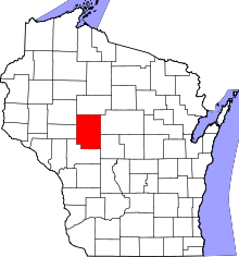 | |
| Villages | ||
| Towns | ||
| CDPs | ||
| Unincorporated communities | ||
| Ghost towns | ||
| Footnotes | ‡This populated place also has portions in an adjacent county or counties | |
Municipalities and communities of Marathon County, Wisconsin, United States | ||
|---|---|---|
| Cities | 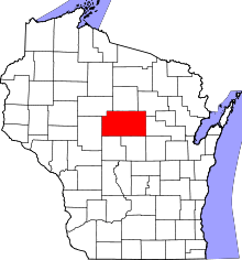 | |
| Villages | ||
| Towns |
| |
| CDPs | ||
| Unincorporated communities |
| |
| Ghost towns/ neighborhoods | ||
| Footnotes | ‡This populated place also has portions in an adjacent county or counties | |