Mosinee, Wisconsin
| Mosinee, Wisconsin | |
|---|---|
| City | |
 Mosinee, Wisconsin Location within the state of Wisconsin | |
| Coordinates: 44°47′30″N 89°42′19″W / 44.79167°N 89.70528°WCoordinates: 44°47′30″N 89°42′19″W / 44.79167°N 89.70528°W | |
| Country | United States |
| State | Wisconsin |
| County | Marathon |
| Area[1] | |
| • Total | 8.54 sq mi (22.12 km2) |
| • Land | 7.77 sq mi (20.12 km2) |
| • Water | 0.77 sq mi (1.99 km2) |
| Population (2010)[2] | |
| • Total | 3,988 |
| • Estimate (2012[3]) | 3,982 |
| • Density | 513.3/sq mi (198.2/km2) |
| Time zone | Central (CST) (UTC-6) |
| • Summer (DST) | CDT (UTC-5) |
| ZIP code | 54455 |
| Area code(s) | 715 & 534 |
| Website |
mosinee |
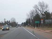
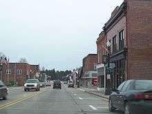
Mosinee is a city in Marathon County, Wisconsin, United States. It is part of the Wausau, Wisconsin Metropolitan Statistical Area. The population was 3,988 at the 2010 census.[4]
History
Mock Communist invasion
On May 1, 1950, local residents acting as Communist invaders seized control of Mosinee.[5][6]
The action was a part of an elaborate pageant organized by the Wisconsin Department of the American Legion. The "Communists" dragged Mayor Ralph E. Kronenwetter and Police Chief Carl Gewiss out of their beds. Mayor Kronenwetter surrendered at 10:15 AM in the town's new "Red Square" with a pistol to his back. The police chief was reported to have resisted and was "liquidated".
Roadblocks were set up around Mosinee, the library was "purged", prices of goods were inflated for the duration of the coup, and local restaurants served Russian black bread and potato soup for lunch.[7]
As he arrived at a rally to restore democracy to the community the night of May 1 Mayor Kronenwetter suffered a cerebral hemorrhage and never regained consciousness. He died five days later on May 6, 1950 at age 49. The mayor's doctor said the excitement and exertion probably contributed to his collapse.
Franklin Baker, commander of the local American Legion post, said, "It was a terrible coincidence."[8]
Local minister Will La Brew Bennett, 72, who, during the Communist invasion, demonstrated to the media how he would hide his Bible in the church organ if the Communists really invaded and was herded with other residents into a barbed-wire ringed "concentration camp" near "Red Square", was found dead in his bed hours after the mayor's death on May 7, 1950.[9]
Geography
Mosinee is located at 44°47'30" North, 89°42'19" West (44.791709, −89.705301).[10]
According to the United States Census Bureau, the city has a total area of 8.54 square miles (22.12 km2), of which, 7.77 square miles (20.12 km2) is land and 0.77 square miles (1.99 km2) is water.[1]
Demographics
| Historical population | |||
|---|---|---|---|
| Census | Pop. | %± | |
| 1880 | 201 | — | |
| 1890 | 427 | 112.4% | |
| 1900 | 657 | 53.9% | |
| 1910 | 482 | −26.6% | |
| 1920 | 1,161 | 140.9% | |
| 1930 | 1,229 | 5.9% | |
| 1940 | 1,361 | 10.7% | |
| 1950 | 1,453 | 6.8% | |
| 1960 | 2,067 | 42.3% | |
| 1970 | 2,395 | 15.9% | |
| 1980 | 3,015 | 25.9% | |
| 1990 | 3,820 | 26.7% | |
| 2000 | 4,063 | 6.4% | |
| 2010 | 3,988 | −1.8% | |
| Est. 2015 | 4,030 | [11] | 1.1% |
2010 census
As of the census[2] of 2010, there were 3,988 people, 1,660 households, and 1,110 families residing in the city. The population density was 513.3 inhabitants per square mile (198.2/km2). There were 1,791 housing units at an average density of 230.5 per square mile (89.0/km2). The racial makeup of the city was 97.6% White, 0.3% African American, 0.5% Native American, 0.5% Asian, 0.5% from other races, and 0.7% from two or more races. Hispanic or Latino of any race were 1.3% of the population.
There were 1,660 households of which 32.0% had children under the age of 18 living with them, 50.4% were married couples living together, 10.8% had a female householder with no husband present, 5.6% had a male householder with no wife present, and 33.1% were non-families. 27.5% of all households were made up of individuals and 10.9% had someone living alone who was 65 years of age or older. The average household size was 2.39 and the average family size was 2.89.
The median age in the city was 39.1 years. 25% of residents were under the age of 18; 7.1% were between the ages of 18 and 24; 26.7% were from 25 to 44; 25.5% were from 45 to 64; and 15.6% were 65 years of age or older. The gender makeup of the city was 49.2% male and 50.8% female.
2000 census
As of the census[13] of 2000, there were 4,063 people, 1,635 households, and 1,111 families residing in the city. The population density was 522.2 people per square mile (201.6/km²). There were 1,711 housing units at an average density of 219.9 per square mile (84.9/km²). The racial makeup of the city was 98.79% White, 0.12% Black or African American, 0.12% Native American, 0.22% Asian, 0.32% from other races, and 0.42% from two or more races. Hispanic or Latino of any race were 0.69% of the population.
There were 1,635 households out of which 34.5% had children under the age of 18 living with them, 54.0% were married couples living together and 32.0% were non-families. 26.9% of all households were made up of individuals and 12.4% had someone living alone who was 65 years of age or older. The average household size was 2.47 and the average family size was 3.00.
In the city the population was spread out with 26.3% under the age of 18, 8.1% from 18 to 24, 30.1% from 25 to 44, 20.3% from 45 to 64, and 15.2% who were 65 years of age or older. The median age was 35 years. For every 100 females there were 95.0 males. For every 100 females age 18 and over, there were 89.7 males.
The median income for a household in the city was $46,109, and the median income for a family was $51,776. Males had a median income of $34,494 versus $25,572 for females. The per capita income for the city was $18,700. About 2.8% of families and 5.5% of the population were below the poverty line, including 4.3% of those under age 18 and 7.9% of those age 65 or over.
Transportation
Central Wisconsin Airport (KCWA) is located 2 miles (3 km) southeast of the Mosinee central business district.
Education
Joseph Dessert Library
Joseph Dessert came from Canada to Mosinee (then known as "Little Bull Falls") in 1844. He built and equipped a free library for the community. Dedicated on February 11, 1899, the building was used as a library, as well as a post office, village hall, and school, and it was the scene of many community events, including dances and balls. The library was the only place in the community with theater facilities, so amateur plays were often presented there, and school commencements were held in the Grand Hall. The library existed as a city library until 1974, when the library and municipal boards recommended that the Joseph Dessert Library should join the Marathon County Public Library (MCPL). Since then, it has also come to be known as the MCPL – Mosinee Branch.
Celebrations have marked two significant anniversaries for the library, the first in 1949 at the 50th anniversary, and the second in 1999 at the time of the library's 100th year. Several renovations have also taken place, with the most recent occurring in 1995 as part of a county-wide building and improvement program for libraries. Today, the library maintains its status in the City of Mosinee as both an important community service and as a building significant to the history of the community. The library building is listed on the National Register of Historic Places.
Notable people
- John Altenburgh, Jazz/Blues musician and composer
- Kevin Cywinski, NASCAR driver
- Willis F. La Du, state legislator
- Kole Heckendorf, football player
- William A. Kasten, state legislator
- Sebastian Kronenwetter, pioneer, businessman, state legislator
- Thomas J. Springer, state legislator
- Henry M. Thompson, state legislator
References
- 1 2 "US Gazetteer files 2010". United States Census Bureau. Retrieved 2012-11-18.
- 1 2 "American FactFinder". United States Census Bureau. Retrieved 2012-11-18.
- ↑ "Population Estimates". United States Census Bureau. Retrieved 2013-06-24.
- ↑ "Profile of General Population and Housing Characteristics: 2010 Demographic Profile Data (DP-1): Mosinee city, Wisconsin". U.S. Census Bureau, American Factfinder. Retrieved September 7, 2012.
- ↑ Richard M. Fried, 1998. The Russians are Coming! The Russians are Coming! Pageantry and Patriotism in Cold-War America (Oxford University Press, New York, ch. 4).
- ↑ "Mosinee in Hands of 'Reds' After a Make Believe Coup", Milwaukee Journal, May 1, 1950
- ↑ Town Deserts U.S. For Day In Soviet; The 'Communists' Take Over A Wisc... – Free Preview – The New York Times
- ↑ MAYOR, MINISTER DEAD AFTER MOCK RED COUP – Free Preview – The New York Times
- ↑ CONELRAD | READ ALERT: AMERICAN LEGION MAGAZINE – JUNE 1950
- ↑ "US Gazetteer files: 2010, 2000, and 1990". United States Census Bureau. 2011-02-12. Retrieved 2011-04-23.
- ↑ "Annual Estimates of the Resident Population for Incorporated Places: April 1, 2010 to July 1, 2015". Retrieved July 2, 2016.
- ↑ "Census of Population and Housing". Census.gov. Retrieved June 4, 2015.
- ↑ "American FactFinder". United States Census Bureau. Retrieved 2008-01-31.
External links
 |
Schofield | | ||
| Marshfield | |
Shawano | ||
| ||||
| | ||||
| Wisconsin Rapids |
Municipalities and communities of Marathon County, Wisconsin, United States | ||
|---|---|---|
| Cities | 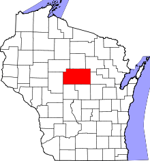 | |
| Villages | ||
| Towns |
| |
| CDPs | ||
| Unincorporated communities |
| |
| Ghost towns/ neighborhoods | ||
| Footnotes | ‡This populated place also has portions in an adjacent county or counties | |