Ruthville, North Dakota
| Ruthville, North Dakota | |
|---|---|
| Census-designated place & Unincorporated community | |
|
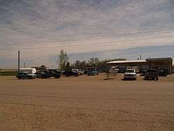
Street in Ruthville | |
 Ruthville, North Dakota | |
| Coordinates: 48°22′18″N 101°17′56″W / 48.37167°N 101.29889°WCoordinates: 48°22′18″N 101°17′56″W / 48.37167°N 101.29889°W | |
| Country | United States |
| State | North Dakota |
| County | Ward |
| Area[1] | |
| • Total | 0.153 sq mi (0.40 km2) |
| • Land | 0.153 sq mi (0.40 km2) |
| • Water | 0 sq mi (0 km2) |
| Elevation | 1,654 ft (504 m) |
| Population (2010)[2] | |
| • Total | 191 |
| • Density | 1,200/sq mi (480/km2) |
| Time zone | Central (CST) (UTC-6) |
| • Summer (DST) | CDT (UTC-5) |
| Area code(s) | 701 |
| GNIS feature ID | 1031054[3] |
Ruthville is a census-designated place and unincorporated community in Ward County, North Dakota, United States. Its population was 191 as of the 2010 census.[2]
Ruthville was named after William Mackenroth's daughter Ruth, in 1936, and consisted of a grocery store and gasoline station. The store was leased and then purchased by Bernhard "Bennie" Schimmelpfennig. His sister Esther ran the store while he was in the Army during World War II. He opened the Jet Motel and Cafe that he named after the new Minot Air Base. He also ran the Ruthville Trailer Park. At one time, Bennie owned everything in Ruthville, except for the Hardy Lieberg Sr. home, Bennie's in-laws. When Bennie bought the store, there was no trees. He planted over 7,000 trees in the area.[4]
References
- ↑ "US Gazetteer files: 2010, 2000, and 1990". United States Census Bureau. 2011-02-12. Retrieved 2011-04-23.
- 1 2 "American FactFinder". United States Census Bureau. Retrieved 2011-05-14.
- ↑ "Ruthville". Geographic Names Information System. United States Geological Survey.
- ↑ "Bernhard Schimmelpfennig". The Bismark Tribune. Retrieved 22 November 2013.
Municipalities and communities of Ward County, North Dakota, United States | ||
|---|---|---|
| Cities | 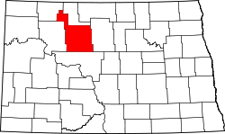 | |
| Townships |
| |
| CDPs | ||
| Unincorporated communities |
| |