Ryder, North Dakota
| Ryder, North Dakota | |
|---|---|
| City | |
|
Business district of Ryder | |
 Location of Ryder, North Dakota | |
| Coordinates: 47°55′2″N 101°40′25″W / 47.91722°N 101.67361°WCoordinates: 47°55′2″N 101°40′25″W / 47.91722°N 101.67361°W | |
| Country | United States |
| State | North Dakota |
| County | Ward |
| Area[1] | |
| • Total | 0.34 sq mi (0.88 km2) |
| • Land | 0.33 sq mi (0.85 km2) |
| • Water | 0.01 sq mi (0.03 km2) |
| Elevation | 2,103 ft (641 m) |
| Population (2010)[2] | |
| • Total | 85 |
| • Estimate (2014)[3] | 82 |
| • Density | 257.6/sq mi (99.5/km2) |
| Time zone | Central (CST) (UTC-6) |
| • Summer (DST) | CDT (UTC-5) |
| ZIP code | 58779 |
| Area code(s) | 701 |
| FIPS code | 38-69460 |
| GNIS feature ID | 1031059[4] |
| Website | www.rydernd.com/ |
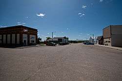
Ryder is a city in Ward County, North Dakota, United States. The population was 85 at the 2010 census.[5] It is part of the Minot Micropolitan Statistical Area. Ryder was founded in 1906.
Geography
Ryder is located at 47°55.0′N 101°40.4′W / 47.9167°N 101.6733°W (47.9175, -101.6738).[6] According to the United States Census Bureau, the city has a total area of 0.34 square miles (0.88 km2), of which, 0.33 square miles (0.85 km2) is land and 0.01 square miles (0.03 km2) is water.[1]
Demographics
| Historical population | |||
|---|---|---|---|
| Census | Pop. | %± | |
| 1910 | 338 | — | |
| 1920 | 483 | 42.9% | |
| 1930 | 457 | −5.4% | |
| 1940 | 467 | 2.2% | |
| 1950 | 330 | −29.3% | |
| 1960 | 264 | −20.0% | |
| 1970 | 211 | −20.1% | |
| 1980 | 158 | −25.1% | |
| 1990 | 121 | −23.4% | |
| 2000 | 92 | −24.0% | |
| 2010 | 85 | −7.6% | |
| Est. 2015 | 82 | [7] | −3.5% |
| U.S. Decennial Census[8] 2014 Estimate[3] | |||
2010 census
As of the census[2] of 2010, there were 85 people, 42 households, and 22 families residing in the city. The population density was 257.6 inhabitants per square mile (99.5/km2). There were 62 housing units at an average density of 187.9 per square mile (72.5/km2). The racial makeup of the city was 96.5% White and 3.5% Native American.
There were 42 households of which 26.2% had children under the age of 18 living with them, 42.9% were married couples living together, 2.4% had a female householder with no husband present, 7.1% had a male householder with no wife present, and 47.6% were non-families. 47.6% of all households were made up of individuals and 23.8% had someone living alone who was 65 years of age or older. The average household size was 2.02 and the average family size was 2.82.
The median age in the city was 48.5 years. 18.8% of residents were under the age of 18; 6% were between the ages of 18 and 24; 21.2% were from 25 to 44; 25.9% were from 45 to 64; and 28.2% were 65 years of age or older. The gender makeup of the city was 58.8% male and 41.2% female.
2000 census
As of the census of 2000, there were 92 people, 44 households, and 23 families residing in the city. The population density was 282.9 people per square mile (107.6/km2). There were 67 housing units at an average density of 206.1 per square mile (78.4/km2). The racial makeup of the city was 97.83% White, 1.09% Native American and 1.09% Asian.
There were 44 households out of which 25.0% had children under the age of 18 living with them, 45.5% were married couples living together, 6.8% had a female householder with no husband present, and 45.5% were non-families. 43.2% of all households were made up of individuals and 13.6% had someone living alone who was 65 years of age or older. The average household size was 2.09 and the average family size was 2.83.
In the city the population was spread out with 22.8% under the age of 18, 3.3% from 18 to 24, 18.5% from 25 to 44, 44.6% from 45 to 64, and 10.9% who were 65 years of age or older. The median age was 46 years. For every 100 females there were 130.0 males. For every 100 females age 18 and over, there were 115.2 males.
The median income for a household in the city was $26,875, and the median income for a family was $27,188. Males had a median income of $26,250 versus $14,792 for females. The per capita income for the city was $16,497. There were 18.5% of families and 30.1% of the population living below the poverty line, including 55.6% of under eighteens and 28.6% of those over 64.
Climate
This climatic region is typified by large seasonal temperature differences, with warm to hot (and often humid) summers and cold (sometimes severely cold) winters. According to the Köppen Climate Classification system, Ryder has a humid continental climate, abbreviated "Dfb" on climate maps.[9]
References
- 1 2 "US Gazetteer files 2010". United States Census Bureau. Retrieved 2012-06-14.
- 1 2 "American FactFinder". United States Census Bureau. Retrieved 2012-06-14.
- 1 2 "Population Estimates". United States Census Bureau. Retrieved June 3, 2015.
- ↑ "US Board on Geographic Names". United States Geological Survey. 2007-10-25. Retrieved 2008-01-31.
- ↑ "2010 Census Redistricting Data (Public Law 94-171) Summary File". American FactFinder. United States Census Bureau. Retrieved 2011-05-02.
- ↑ "US Gazetteer files: 2010, 2000, and 1990". United States Census Bureau. 2011-02-12. Retrieved 2011-04-23.
- ↑ "Annual Estimates of the Resident Population for Incorporated Places: April 1, 2010 to July 1, 2015". Retrieved July 2, 2016.
- ↑ United States Census Bureau. "Census of Population and Housing". Retrieved 2013-10-23.
- ↑ Climate Summary for Ryder, North Dakota
Municipalities and communities of Ward County, North Dakota, United States | ||
|---|---|---|
| Cities | 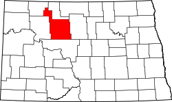 | |
| Townships |
| |
| CDPs | ||
| Unincorporated communities |
| |