Salem Downtown State Street – Commercial Street Historic District
|
Salem Downtown State Street – Commercial Street Historic District | |
|
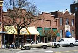
The historic district's Smith & Wade Building (left, historic name, ca. 1870) and Salvation Army Building (right, historic name, ca. 1930) in 2008 | |
|
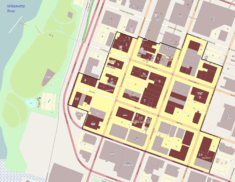
The historic district boundaries and contributing buildings in downtown Salem | |
| Location | Salem, Oregon, roughly bounded by Ferry, High, Chemeketa, and Front Streets |
|---|---|
| Coordinates | 44°56′24″N 123°02′22″W / 44.94009°N 123.0394°WCoordinates: 44°56′24″N 123°02′22″W / 44.94009°N 123.0394°W |
| Area | Approx. 44 acres (18 ha)[1] |
| Built | ca. 1867 – ca. 1950[1] |
| Architect | Ellis F. Lawrence, Holly A. Cornell, Walter D. Pugh, Wilbur F. Boothby, G.W. Rhodes, Fred A. Legg, John Gray, Pietro Belluschi, Morris H. Whitehouse, J.S. Coulter, C.S. McNally, William C. Knighton, Leigh L. Dougan, Robert Rowe, others[1] |
| Architectural style | Italianate, Queen Anne, Richardsonian Romanesque, Commercial, Revival styles, Modernistic, others[1] |
| NRHP Reference # | 01001067 |
| Added to NRHP | September 28, 2001 |
The Salem Downtown State Street – Commercial Street Historic District comprises a portion of the central business district of Salem, Oregon, United States. Located on the Willamette River transportation corridor and near Jason Lee's Mission Mill, Salem's downtown area was first platted in 1846. Subsequent development patterns closely reflected the drivers of Salem's growth as an important agricultural and commercial center. Surviving buildings represent a wide range of architectural styles from the 1860s through the 1950s.[1] The district was added to the National Register of Historic Places in 2001.[2]
See also
- National Register of Historic Places listings in Marion County, Oregon
- Adolph Block
- Bush–Breyman Block
- Capitol Center (Oregon)
- Elsinore Theatre
- Grand Theater (Salem, Oregon)
- Pacific Building (Salem, Oregon)
- Reed Opera House and McCornack Block Addition
References
- 1 2 3 4 5 Evans, Gail E. H. (July 2001), National Register of Historic Places Registration Form: Salem Downtown State Street – Commercial Street Historic District (PDF), retrieved March 7, 2016.
- ↑ Oregon Parks and Recreation Department, Oregon Historic Sites Database, retrieved October 14, 2013.
External links
 Media related to Salem Downtown State Street - Commercial Street Historic District at Wikimedia Commons
- National Register of Historic Places photographic file
| Lists by county |  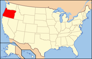 | |
|---|---|---|
| Portland lists | ||
| Other lists |
| |
This article is issued from Wikipedia - version of the 11/24/2016. The text is available under the Creative Commons Attribution/Share Alike but additional terms may apply for the media files.