Samuel Miner House
|
Samuel Miner House | |
|
1975 photo | |
  | |
| Location | Hewitt Rd., North Stonington, Connecticut |
|---|---|
| Coordinates | 41°26′57″N 71°53′26″W / 41.44917°N 71.89056°WCoordinates: 41°26′57″N 71°53′26″W / 41.44917°N 71.89056°W |
| Area | 6 acres (2.4 ha) |
| Built | 1717 |
| Architectural style | Colonial, One-Room Plan |
| NRHP Reference # | 76001995[1] |
| Added to NRHP | June 18, 1976 |
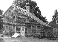
The Samuel Miner House was a historic house on Hewitt Road in North Stonington, Connecticut. It was a colonial three-bay side-chimney structure, built in 1717, that was added to the National Register of Historic Places on June 18, 1976.[2] It was a unique and rare example of a house that was constructed of apple, oak, sycamore and chestnut wood.[3] The house was destroyed by fire in April 2003.[4][5]
See also
References
- ↑ National Park Service (2009-03-13). "National Register Information System". National Register of Historic Places. National Park Service.
- ↑ Clouette, Bruce (18 June 1976). "National Register of Historic Places nomination - Samuel Miner House" (PDF). National Park Service. Retrieved 8 August 2014.
- ↑ Youngken, Richard (1997). Historic Resources Survey, North Stonington, Connecticut. Newport Collaborative Architects.
- ↑ "Fire Ruins N. Stonington Home". The Day. April 4, 2003. Retrieved 8 November 2014.
- ↑ "Farm Committee Minutes, June 30, 2014" (PDF). Town of North Stonington. Retrieved 2015-01-28.
| Topics | |
|---|---|
| Lists by states |
|
| Lists by insular areas | |
| Lists by associated states | |
| Other areas | |
| |
This article is issued from Wikipedia - version of the 12/2/2016. The text is available under the Creative Commons Attribution/Share Alike but additional terms may apply for the media files.