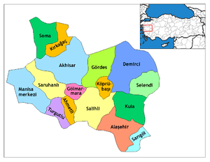
Sarıgöl
| Sarıgöl | |
|---|---|
| District | |
 Location of Sarıgöl within Turkey. | |
 Sarıgöl Location of Sarıgöl | |
| Coordinates: 38°14′N 28°42′E / 38.233°N 28.700°E | |
| Country |
|
| Region | Aegean |
| Province | Manisa |
| Area[1] | |
| • District | 356.99 km2 (137.83 sq mi) |
| Elevation | 194 m (636 ft) |
| Population (2012)[2] | |
| • Urban | 13,785 |
| • District | 36,179 |
| • District density | 100/km2 (260/sq mi) |
| Time zone | EET (UTC+2) |
| • Summer (DST) | EEST (UTC+3) |
| Postal code | 45xxx |
| Area code(s) | 236 |
| Licence plate | 45 |
| Website | www.sarigol.bel.tr |
Sarıgöl is a town and district of Manisa Province in the Aegean region of Turkey. According to the 2000 census, population of the district is 35,621 of which 12,043 live in the town of Sarıgöl.[3] The district covers an area of 357 km2 (138 sq mi),[4] and the town lies at an elevation of 194 m (636 ft).
History
Sarıgöl is a small town located between the provinces of Denizli and Manisa. According to some historians, it has been an important city throughout history. There was an ancient city called Callatebus (Kallatebos) in the vicinity of today's Sarıgöl. The city of Kallatebos (Calletebus) was mentioned by Herodotus in his 7th book's 31st district. The city was between Philadelphia (Alaşehir) and Hierapolis (Pamukkale).
Notes
- ↑ "Area of regions (including lakes), km²". Regional Statistics Database. Turkish Statistical Institute. 2002. Retrieved 2013-03-05.
- ↑ "Population of province/district centers and towns/villages by districts - 2012". Address Based Population Registration System (ABPRS) Database. Turkish Statistical Institute. Retrieved 2013-02-27.
- ↑ Turkish Statistical Institute. "Census 2000, Key statistics for urban areas of Turkey" (in Turkish). Archived from the original (XLS) on 2007-07-22. Retrieved 2009-04-11.
- ↑ Statoids. "Statistical information on districts of Turkey". Archived from the original on 2010-05-26. Retrieved 2009-04-04.
References
- Falling Rain Genomics, Inc. "Geographical information on Sarıgöl, Turkey". Archived from the original on 2012-11-02. Retrieved 2009-04-11.
External links
- District governor's official website (Turkish)
- District municipality's official website (Turkish)
- Road map of Sarıgöl and environs
- Various images of Sarıgöl
Coordinates: 38°14′25″N 28°41′56″E / 38.24028°N 28.69889°E