Soma, Manisa
| Soma | |
|---|---|
| District | |
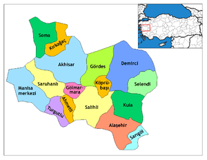 Location of Soma within Turkey. | |
 Soma Location of Soma | |
| Coordinates: 39°11′N 27°37′E / 39.183°N 27.617°E | |
| Country |
|
| Region | Aegean |
| Province | Manisa |
| Area[1] | |
| • District | 838.87 km2 (323.89 sq mi) |
| Elevation | 161 m (528 ft) |
| Population (2012)[2] | |
| • Urban | 76,305 |
| • District | 102,666 |
| • District density | 120/km2 (320/sq mi) |
| Time zone | EET (UTC+2) |
| • Summer (DST) | EEST (UTC+3) |
| Postal code | 45500 |
| Area code(s) | 236 |
| Licence plate | 45 |
| Website | www.soma.bel.tr |
Soma is a town and district of Manisa Province in the Aegean region of Turkey. According to the 2009 census, the population of the district is 101,011, of which 74,158 live in the town of Soma.[3] The district covers an area of 839 km2 (324 sq mi),[4] and the town lies at an elevation of 161 m (528 ft).
Economy
Lignite mining and a lignite-fired thermal power plant are the main economic activities in Soma.[5] During World War I the mines were opened up for production. The lignite extracted during that time was described as being of "very bad" quality. That lignite was burned with German coal for trains in the region. A small portion was exported to İzmir.[6]
The Soma Wind Farm, with 119 wind turbines and an installed total capacity of 140.4 MW, is one of Turkey's largest wind farms.[7]
2014 Soma coal mine disaster
On 13 May 2014, as a result of an explosion caused by a mine fire at the Soma coal mine, 301 workers were killed.[8]
Notes
- ↑ "Area of regions (including lakes), km²". Regional Statistics Database. Turkish Statistical Institute. 2002. Retrieved 2013-03-05.
- ↑ "Population of province/district centers and towns/villages by districts - 2012". Address Based Population Registration System (ABPRS) Database. Turkish Statistical Institute. Retrieved 2013-02-27.
- ↑
- ↑ Statoids. "Statistical information on districts of Turkey". Retrieved 2009-04-04.
- ↑ The Journal of Turkish Weekly. "Soma Manisa Turkey-Thermal Power Plant". Retrieved 2009-04-11.
- ↑ Prothero, G.W. (1920). Anatolia. London: H.M. Stationery Office. p. 101.
- ↑ "'Rüzgar'da en büyük olacak". Vatan (in Turkish). 2010-11-02. Retrieved 2012-06-30.
- ↑ "Faciada son bilanço: 298 ölü". ntvmsnbc. 17 May 2014. Retrieved 17 May 2014.
External links
Coordinates: 39°11′18″N 27°36′32″E / 39.18833°N 27.60889°E