Schaumburg Township, Cook County, Illinois
| Schaumburg Township | |
|---|---|
| Township | |
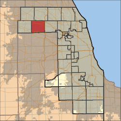 Location in Cook County | |
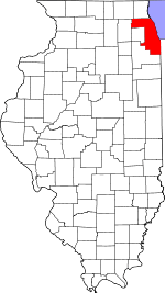 Cook County's location in Illinois | |
| Coordinates: 42°01′41″N 88°05′19″W / 42.02806°N 88.08861°WCoordinates: 42°01′41″N 88°05′19″W / 42.02806°N 88.08861°W | |
| Country | United States |
| State | Illinois |
| County | Cook |
| Area | |
| • Total | 30.96 sq mi (80.18 km2) |
| • Land | 30.73 sq mi (79.60 km2) |
| • Water | 0.22 sq mi (0.58 km2) 0.72% |
| Elevation | 787 ft (240 m) |
| Population (2010) | |
| • Total | 131,288 |
| • Density | 4,272/sq mi (1,649.3/km2) |
| Time zone | CST (UTC-6) |
| • Summer (DST) | CDT (UTC-5) |
| ZIP codes | 60007, 60008, 60010, 60067, 60103, 60107, 60169, 60172, 60173, 60193, 60194, 60195 |
| GNIS feature ID | 0429720 |
| Website |
www |
Schaumburg Township is one of 29 townships in Cook County, Illinois, USA. As of the 2010 census, its population was 131,288.[1] It is the south central township of the Cook County panhandle.
Geography
According to the United States Census Bureau, Schaumburg Township covers an area of 30.96 square miles (80.18 km2); of this, 30.73 square miles (79.60 km2) is land and 0.22 square miles (0.58 km2), or 0.72 percent, is water.[1]
Cities, towns, villages
- Elk Grove Village
- Hanover Park
- Hoffman Estates
- Rolling Meadows (south edge)
- Roselle
- Schaumburg
- Streamwood
Adjacent townships
- Palatine Township (north)
- Elk Grove Township (east)
- Addison Township, DuPage County (southeast)
- Bloomingdale Township, DuPage County (south)
- Wayne Township, DuPage County (southwest)
- Hanover Township (west)
- Barrington Township (northwest)
Cemeteries
The township contains Greve Cemetery.
Major highways
-
 Interstate 90
 -
 Interstate 290
 -
 U.S. Route 20
 -
 Illinois Route 19
 -
 Illinois Route 53
 -
 Illinois Route 58
 -
 Illinois Route 72
Airports and landing strips
- Marriott Heliport
- Schaumburg Municipal Helistop
Lakes
- George Lake
- Merkle Lake
- Moon Lake
- Unity Lake
- Weathersfield Lake
Landmarks
- Busse Woods Forest Preserve
- Schaumburg Regional Airport
Political districts
- Illinois' 6th congressional district
- State House District 44
- State House District 56
- State House District 66
- State Senate District 22
- State Senate District 28
- State Senate District 33
See also
References
- "Schaumburg Township, Cook County, Illinois". Geographic Names Information System. United States Geological Survey. Retrieved 2010-01-10.
- United States Census Bureau 2007 TIGER/Line Shapefiles
- United States National Atlas
- 1 2 "Geographic Identifiers: 2010 Demographic Profile Data (DP-1): Schaumburg township, Cook County, Illinois". U.S. Census Bureau, American Factfinder. Retrieved March 21, 2013.
External links
- Schaumburg Township official website
- City-Data.com
- Illinois State Archives
- Township Officials of Illinois
- Cook County official site
This article is issued from Wikipedia - version of the 11/17/2016. The text is available under the Creative Commons Attribution/Share Alike but additional terms may apply for the media files.