Sefton Central (UK Parliament constituency)
Coordinates: 53°31′23″N 2°59′06″W / 53.523°N 2.985°W
| Sefton Central | |
|---|---|
|
Borough constituency for the House of Commons | |
|
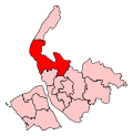
Boundary of Sefton Central in Merseyside. | |
|
Location of Merseyside within England. | |
| County | Merseyside |
| Electorate | 67,696 (December 2010)[1] |
| Current constituency | |
| Created | 2010 |
| Member of parliament | Bill Esterson (Labour) |
| Number of members | One |
| Created from |
Crosby Knowsley North & Sefton East |
| Overlaps | |
| European Parliament constituency | North West England |
Sefton Central is a constituency[n 1] represented in the House of Commons of the UK Parliament since its 2010 creation by Bill Esterson, a member of the Labour Party.[n 2]
Boundaries
- History of boundaries
The constituency replaced much of Crosby along with part of Knowsley North and Sefton East. The new constituency covers Merseyside northern residential suburban areas of Crosby, Blundellsands, Brighton-Le-Sands, Little Crosby, Thornton, and Hightown, Formby and Maghull and the villages and localities of Aintree, Carr Houses, Freshfield, Ince Blundell, Kennessee Green, Lady Green, Little Altcar, Lunt, Lydiate, Melling, Sefton, and Waddicar, in the Metropolitan Borough of Sefton. The constituency has electoral wards:[2]
History
This seat was fought for the first time at the 2010 general election.
At the time, eleven of the constituency's twenty-one councillors were Conservatives followed by the Liberal Democrats who had ten,[n 3] whereas analysis by Rallings and Thrasher indicated that had the Sefton Central constituency existed in 2005, the result would have been: Labour 45.6%, Conservative 33.6%, LibDem 19.2%, giving a Labour majority of 4,950. Some Conservative campaign billboard posters for the Tory candidate Deborah Jones had been defaced during the 2010 election, as had been the case during the 2005 election in Crosby.[3] The Labour Party candidate's majority was 3,862 suggesting a moderate two-party swing.
Constituency profile
The constituency consists of Census Output Areas of a local government district with: a working population whose income is close to the national average and which has close to average reliance on social housing.[4] At the end of 2012 the unemployment rate in the constituency stood as 2.4% of the population claiming jobseekers allowance, compared to the regional average of 4.2%.[5] The borough contributing to the seat has a medium 28.5% of its population without a car, 25.1% of the population without qualifications and a 24.1% with level 4 qualifications or above. In terms of tenure 70.5% of homes are owned outright or on a mortgage as at the 2011 census across the district.[6]
Members of Parliament
| Election | Member[7] | Party | |
|---|---|---|---|
| 2010 | Bill Esterson | Labour | |
Elections
Elections in the 2010s
| Party | Candidate | Votes | % | ± | |
|---|---|---|---|---|---|
| Labour | Bill Esterson | 26,359 | 53.8 | +11.9 | |
| Conservative | Valerie Allen | 14,513 | 29.6 | -4.3 | |
| UKIP | Tim Power | 4,879 | 10.0 | +5.7 | |
| Liberal Democrat | Paula Keaveney | 2,086 | 4.3 | -15.7 | |
| Green | Lindsay Melia | 1,184 | 2.4 | +2.4 | |
| Majority | 11,846 | 24.2 | |||
| Turnout | 49,021 | 72.4 | |||
| Labour hold | Swing | +8.1 | |||
| Party | Candidate | Votes | % | ± | |
|---|---|---|---|---|---|
| Labour | Bill Esterson | 20,307 | 41.9 | -3.7 | |
| Conservative | Debi Jones | 16,445 | 33.9 | +0.4 | |
| Liberal Democrat | Richard Clein | 9,656 | 19.9 | +0.7 | |
| UKIP | Peter Harper | 2,055 | 4.2 | +3.5 | |
| Majority | 3,862 | 8.0 | |||
| Turnout | 48,463 | 71.8 | +11.0 | ||
| Labour hold | Swing | +2.0 | |||
See also
Notes and references
- Notes
- ↑ A county constituency (for the purposes of election expenses and type of returning officer)
- ↑ As with all constituencies, the constituency elects one Member of Parliament (MP) by the first past the post system of election at least every five years.
- ↑ A share of the vote based on the 2008 local election in these seven wards gave Conservative 42.3% Liberal Democrat 34.2% Labour 18.1%.
- References
- ↑ "Electorate Figures - Boundary Commission for England". 2011 Electorate Figures. Boundary Commission for England. 4 March 2011. Retrieved 13 March 2011.
- ↑ The Parliamentary Constituencies (England) Order 2007, Office of Public Sector Information
- ↑ Sefton Central Tory candidate billboards defaced BBC News website, April 30 2010. Accessed 30 December 2011
- ↑ 2001 Census
- ↑ Unemployment claimants by constituency The Guardian
- ↑ 2011 census interactive maps
- ↑ Leigh Rayment's Historical List of MPs – Constituencies beginning with "S" (part 2)
- ↑ "Election Data 2015". Electoral Calculus. Archived from the original on 17 October 2015. Retrieved 17 October 2015.
- ↑ "Sefton Central". BBC News. Retrieved 10 May 2015.
- ↑ "Election Data 2010". Electoral Calculus. Archived from the original on 17 October 2015. Retrieved 17 October 2015.

