Shepperton
| Shepperton | |
 Church Square, Shepperton |
|
 Shepperton |
|
| Area | 6.98 km2 (2.69 sq mi) |
|---|---|
| Population | 9,753 (2011 census)[1] |
| – density | 1,397/km2 (3,620/sq mi) |
| OS grid reference | TQ080672 |
| District | Spelthorne |
| Shire county | Surrey |
| Region | South East |
| Country | England |
| Sovereign state | United Kingdom |
| Post town | SHEPPERTON |
| Postcode district | TW17 |
| Dialling code | 01932 |
| Police | Surrey |
| Fire | Surrey |
| Ambulance | South East Coast |
| EU Parliament | South East England |
| UK Parliament | Spelthorne |
Coordinates: 51°23′N 0°28′W / 51.39°N 0.46°W
Shepperton is a suburban town in the borough of Spelthorne, in the county of Surrey in England, 15 miles (24 km) south west of Charing Cross, London, bounded by the Thames to the south and much of the east and which is in the north-west bisected by the M3 motorway. Shepperton is equidistant between the towns of Chertsey and Sunbury-on-Thames. Shepperton is mentioned in a document of 959 AD and in the Domesday Book, where it was an agricultural village.
In the early 19th century resident writers and poets included Haggard, Peacock, Meredith and Shelley, allured by the Thames beside which they and other wealthy residents lived, painted at Walton Bridge here in 1754 by Canaletto and in 1805 by Turner. Its accessibility was improved by Sunbury Lock and Shepperton Lock built in the 1810s supporting the trade and agricultural barges and later the use of residential narrowboats. The suburbanisation of Shepperton began late for Middlesex, in the latter part of the 19th century, with the construction in 1864 of its railway — the owner of its manor, William Schaw Lindsay sponsored the venture which had aims to be extended via Chertsey and connect to the South Western Main Line. Shepperton's proximity to burgeoning London led to small businesses being established along its high street by the end of the century.
With its film studios and production facilities and electrified railway since the 1930s many more homes have been constructed; its population rose from 1,810 residents in the early 20th century to a little short of 10,000 in 2011. It is an age-diverse commuter settlement. Expansion continues in the form of occasional new housing developments; curtailed by natural considerations — much of the land is formed of protected flood meadows, small lakes or fertile alluvial soil farmland which in part form a green buffer to its motorway. Its Green Belt has The Swan Sanctuary and two SSSIs, one of which is managed by Surrey Wildlife Trust.
History
While a history summary of 1994 indicates that Shepperton meant Shepherd's habitation, which would earlier have transliterated into late Saxon language as Sceapheard-ton,[2] the place has been found in "a document of 959 AD" as Scepertune, which the book Middlesex (Robbins, 1953)[n 1], states instead meant Shepherd's farm.[3] The name of one of the older lanes, Sheep Walk, may date to the medieval period and was perhaps on a wide tract of low-lying meadows which produced the Middlesex wool, namely marsh wool, which was included in a valuation of 1343. The valuation was two years after Edward III imposed wool tax — Middlesex rendered a sack for every 760 acres (310 ha)s of the county (contributing in total 236 sacks) – much of which however appears from contemporary returns to have been collected from other riversides in the county including, in particular, Hampton (which includes Hampton Court).[4]
Shepperton in the Domesday Book of 1086 was recorded by the Norman conquerors as Scepertone,[n 2] with a population of 25 households and was held by Westminster Abbey; (excluding any wood, marsh and heath) it had eight hides, pasture for seven carucates and one weir (worth 6s 8d per year). In total the annual amount rendered was £6.[5]


The Church Lane and Church Square area, leading to and next to the river predates by several centuries the High Street as the village nucleus. When the Thames Valley Railway built in 1864 the terminus of Shepperton railway station, 1 mile (1.6 km) north, for the 12 initial years a single train and track running to and from Strawberry Hill, the village slowly expanded into its northern fields.[6] Its coming which was largely due to contributions and permission of W. S. Lindsay the owner of Shepperton's manor.[7]
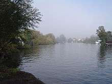
The River Thames was important for transport from the late 13th century and carried barley, wheat, peas and root vegetables to London's markets; later timber, building materials such as bricks, sand and lime, and gunpowder, see the Wey Navigation.[8]
While the village was wholly agricultural until the 19th century, there are originally expensive gravestones of the local minor gentry in the churchyard, two of which are dedicated to their naturalised black servants, Benjamin and Cotto Blake who both died in 1781. These bear the inscription "Davo aptio, Argo fidelior, ipso Sanchone facetior". During this long period since the conquest the wealth of the local rector and his bishop was great: William Grocyn was rector 1504–1513 and was an Oxford classical academic who corresponded regularly with Erasmus and Lewis Atterbury (1707–31) expended much of the large parish revenues on having the large tower rebuilt.[3]
A large net income of rents and tithes of £499 per year was paid to the rectory belonging to S. H. Russell in 1848; this compares to £600 of poor relief, including for supporting its workhouse, paid out in 1829.[7][9][10]
A change to secular council-administered rather than church-administered public services followed the establishment of poor law unions and Sanitary Districts and was completed with the founding, in 1889, of the Staines Rural District (and Middlesex County Council from 1896). In 1930 on the rural district's abolition, Shepperton became part of the Sunbury-on-Thames Urban District until its dissolution into a reduced and reconfigured county of Surrey in 1965. Three districts of the historic county thus did not become part of Greater London: Staines Urban District also joined Surrey and Potters Bar Urban District joined Hertfordshire.[11]
- Use in semi-fiction and alleged hauntings
In semi-fiction, George Eliot's Scenes of Clerical Life telling the Sad Fortunes of The Rev. Amos Barton, gives a thinly veiled picture of Chilvers Coton's church and village in the early 19th century in which she uses the name Shepperton. If anything real is to be gleaned for its use, it is perhaps a passing similarity. Shepperton Manor by John Mason Neale was contemporaneously written in 1844 fifteen years after he had spent six years living in the village. Old parts of Shepperton are said to be haunted by the ghost of a headless monk.[12] Battlecrease Hall is alleged by its owners and certain visitors to have poltergeists.[13]
Conservation areas
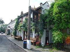
Church Square in Old Shepperton
Leading to this is a short, since 1989 bypassed, winding lane from the High Street to Church Square, flanked by Shepperton Manor and the cricket ground, with some listed walls. Sir Nikolaus Pevsner described the view looking towards the south-east of the square with its now listed buildings and river opening as "one of the most perfect village pictures that the area has to offer".[8] It offers two pub/restaurants including the first of the chain Blubeckers[14][15] and two hotels, the Anchor Hotel[16] and the Warren Lodge Hotel.[17] In this little square there is also the King's Head public house.[18]
The riverside manor, late 18th century, (its predecessor, as with the church here, predates the 12th century),[19] features a room painted and rendered to look like a tent or draped damask. Also Grade II* listed is the c. 1500 timber framed Old Rectory refronted in the early 18th century,[7] and including a reception hall built in 1498.[20] Its front cladding has mathematical tiles.[8]
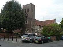
Listed in the same high category of listed building is the parish church, St Nicholas' – its dedication is as with the ancient riverside churches of Thames Ditton and Chiswick.[21][n 3] Also architecturally Grade II* is restored half timbered Winches Cottage on the west side of the lane which is 17th century.[22]
Lower Halliford
The town includes the neighbourhood of Lower Halliford, formerly a near but separate hamlet, which historian Susan Reynolds places at the eastern end of a reduced, river bend-consumed half of the early medieval village, east of the Old Shepperton Conservation Area due to erosion.[7][23]
This area is typified by a small number of detached classical three-storey 18th century riverside houses high on the riverside road on the outside of the river bend; the bend being flanked by riverside meadows with small boat moorings, low rise chalet-style houses to the south west, the Las Palmas Estate, named after the land once being that of the Spanish Ambassador; further west by the wooded Shepperton Cricket Club and by the village Green, Bishop Duppas Park to the east, formerly Lower Halliford Common and in a small part owned by the Old Manor House (Halliford).[24]
From the 1760s—1860s a ropery was an industry here then from the 1860s—1870s brick clay was extracted.[8]
Halliford Manor, confusingly also called The Old Manor, dates to at least the 13th century and ownership became royal, being held by Elizabeth I and the wives of Charles I and Charles II. The Bishop of Winchester, Brian Duppa (1588–1662) owned the waterside meadows adjoining to the south and was also an important landowner in Croydon's history, see Duppas Hill.[n 4] Wealthy writers built or expanded homes here in the 19th century, primarily as summer residences, such as Rider Haggard, Thomas Love Peacock, George Meredith and Percy Bysshe Shelley.[7][8]
The Old Manor became yet another rebuilt Georgian house. The house which features a modillioned eaves cornice and glazing-bar sash windows to the first floor. Halliford School in the centre of this area was the 18th–19th century home of Emma Hamilton, mistress of Admiral Nelson.[25][26]
The 21st century fully renovated hotel and restaurant (formerly the Ship), Harrison's with river views[27] is here beside the shorter Red Lion public house which in turn has a narrow, secluded south-facing public house picnic area overlooking the relatively narrow, non-tidal river Thames. It is for this reason a bridge and ferry was recorded here from 1274 to 1410.[8]
The tern is applicable also to the mostly riverside homes and public park almost surrounded by the River Thames, south of the road from Kingston to Chertsey including next to Walton Bridge by Walton on Thames. The main park is Bishop Duppas Park and almost surrounds completely the Old Manor.
There is mention of Halliford in 962 and there was a settlement there by 1194. However the division into Upper and Lower Halliford does not appear until the late 13th century. Upper Halliford is a large hamlet in the parish of Sunbury, but Lower Halliford was almost certainly the main settlement of the manor.[28] The creation of Desborough Cut diverted the main navigation of the Thames away from the Lower Halliford and Shepperton loop, rendering flooding far less common.[8]
The poet Thomas Love Peacock lived at Elm Bank House here from 1822 until his death in 1866.[29] He is buried in Shepperton New Cemetery.[30]
Manygate Lane
The field land and large houses on this estate were bought by Lyon Homes from landowner and developer Edward Scott in the 1950s.
This estate of buildings on this street are in a conservation area for proving a successful modular development in geometric, white-painted modernism from in the 1960s, one of very few private sector estate housing experiments of the 1960s with terraced, white panelled communal landscaped front gardens by Swiss architect Edward Schoolheifer; this American Radburn style was also used by Eric Lyons Span Developments in Ham Common, Richmond, London, Blackheath, London and New Ash Green, Kent.[8]
Localities
The conservation areas of Old Shepperton and Lower Halliford are localites, as is Littleton.
Charlton
51°24′40″N 0°26′38″W / 51.411°N 0.444°W
Charlton is a suburban hamlet and narrow area to the north, bounded to the west by the Queen Mary Reservoir in Littleton, bounded to the east and south by Thames water treatment works from that reservoir and by the M3 motorway. As a well-developed hamlet, bounded by farms, it also referred to as a village or neighbourhood. Its post town is Shepperton. Its parish is Sunbury-on-Thames. In the south of the neighbourhood, on the Shepperton side of the motorway are a general waste transfer station, further fields and Sunbury Golf Course, which has 18 holes and is bisected by the Shepperton railway line.
Charlton appears in Domesday Book as Cerdentone. It was held by Roger de Rames. Its domesday assets were: 5 hides; 1½ ploughs (with potential for 3½), meadow for 4 ploughs, cattle pasture. It rendered £1 10s 0d.[5] However this manor was in the parish of Sunbury and unlike the three adjoining manors, Shepperton, Halliford and Sunbury did not reach down to the river public meadowlands, used for grazing of animals.[7]
Shepperton Green
51°23′53″N 0°27′32″W / 51.398°N 0.459°W
Shepperton Green is that part of the village which continues immediately west of the M3 motorway, as such, north-west of the village centre. Across the River Ash, Surrey, which is no more than a stream most of the year, adjoining, to its north is Littleton. Taken together with Littleton, three farms operate on the edges of this conjoined residential area, providing a buffer to the north and west. Shepperton's central SSSI is on the south side of the motorway Sheep Lake Walk and meadows, managed by Surrey Wildlife Trust. To the west are large lakes (one sifted and worked for gravel). This means that Shepperton Green with Littleton is buffered to all sides, except for its eastern side with its road bridge to Shepperton proper, classified as Shepperton Town ward and county council electoral division. This area is currently grouped with Laleham for all local elections.
High Street and economy
Shepperton has a traditional high street, shorter than the nearby Ashford with two medium size supermarkets, the village hall, library, shops, bank, hairdressers, a wide range of restaurants, a public house and several cafés, and has the railway terminus at one end.
Shepperton railway station saw high ticketed entries and exits for a settlement of its size to 422,000 (6 April 2010 – 5 April 2011), being a terminus with main commercial destinations being in the City of London, Kingston upon Thames commercial hubs of West London and South London accessed along the route, this is supplemented by secondary school usage, with a substantial state school and private school.[31]
History board
The Village Hall in the High Street has a large depiction of the economic life and of the history of the town. In October 2011, a group of children from St Nicholas C of E Primary School won a competition to create the history board, which was then edited by a graphic designer and officially opened by the mayor with a large ceremony and some press, after Sunbury had held a similar competition. The board itself includes a grassland to represent the pastures and provides major facts.
Public services
Four infant/junior/primary schools, a senior comprehensive school and senior private school are in the village.
Home Office policing in Shepperton is provided by Surrey Police. Public transport is co-ordinated by Surrey County Council who also provide the statutory emergency fire and rescue service who have a station in Sunbury.
St Peter's Hospital on the far side of Chertsey is a large NHS hospital administrated by Ashford and St Peter's Hospitals NHS Trust. It was opened under its existing name in 1947. The South East Coast Ambulance Service Foundation Trust provides emergency patient transport to and from this facility. Other forms of health care are provided for locally by several small clinics and surgeries.
Waste management is co-ordinated by the local authority via the Surrey Waste Disposal Authority and domestic waste collected by Spelthorne Borough Council. Locally produced inert waste for disposal is sent to landfill in Alfold and Shefford, and a proportion to energy from waste plants in Slough and Kent to lower landfill tax. Plans have been approved to permit gasification in Charlton in the north of the Shepperton post town as part of the county's Eco Park to take up to half of the county's residual waste. Shepperton's Distribution Network Operator for electricity is UK Power Networks; aside from renewables there are no power stations in the area. Thames Water manages Shepperton's drinking and waste water; water supplies being sourced from the London sources including several reservoirs fed by the River Thames locally. There are water treatment works at Ashford, Hampton and sewage treatment works at Isleworth.
Topography
Shepperton has a long boundary with the River Thames in its southernmost salient, which almost surrounds Spelthorne. Old Shepperton is almost surrounded by the extreme southern meander within this. Prehistoric glacial retreat north of this has made the north bank almost flat for a considerable distance and as such, elevation never exceeds 14 m above mean sea level (on the border of Laleham).[32] The river never exceeds 11.5 m, (beside Dumsey Meadow and under Chertsey Bridge). The lowest elevation is 9 m in flood meadows at the confluence of the Ash with the Thames. The Ash is the border with Littleton and Sunbury-on-Thames (mostly, to the northeast, with its technical hamlet, Upper Halliford).
Dumsey Meadow SSSI is the only piece of undeveloped, unfenced water meadow by the river remaining on the River Thames below Caversham, and is home to a variety of rare plants and insects.[33]
The Swan Sanctuary moved to an old gravel extraction site by Fordbridge Road in 2005 from its former base in Egham.
On the opposite bank are in downstream order are Chertsey Bridge and Chertsey Meads, the now residential Hamm Court riverside neighbourhood, three islands, (the first two of which have multiple properties) (Lock[n 5], Hamhaugh and D'Oyly Carte, one large man-made island, (Desborough), and the riverside parts of Walton on Thames, the upstream part of which is also open land, Cowey Sale Park.[n 6] The towpath is the official route of three passing through the Shepperton reaches (of the Thames Path) as heading upstream from Hampton Court Palace another marked version takes Walton Bridge, the official version takes the Shepperton-Weybridge Ferry and another marked version crosses to the north bank at Chertsey Bridge.[32]
- Upper Halliford
Upper Halliford has since the early 20th century been in Shepperton post town, and almost contiguous, but with its own station, residential roads, fair and shopping parade, even an Upper Halliford Village sign. Arguably in modern analysis it is a village, with the second highest concentration of development in the post town.[32]
- Shepperton Green
This neighbourhood is smaller than the adjoining town, separated by the M3 motorway and some adjoining meadows and fields. The second of the borough's Green Belt SSSIs, Sheep Walk Meadows, is a key feature of Shepperton Green, bounding it, to its south. A Saxon and medieval burial ground gives its name to the Saxon Junior School who use it for playing fields and has Scheduled status.[34] A farm combined with a significant amount of fishing and gravel lakes form the outskirts and within the clustered settlement an estate of the homes was built as non-serving personally barracks for the British Army.[35]
 |
Laleham | across Upper Halliford or Charlton (both Shepperton, TW17): Ashford Littleton |
Upper Halliford/Sunbury-on-Thames | |
| Chertsey | |
Walton-on-Thames | ||
| ||||
| | ||||
| Addlestone | Weybridge | Oatlands, Weybridge |
Demography and housing
Historic figures
The population of Shepperton, according to the census of 1801, was 731. This number increased gradually to 858 forty years later, increasing further to the end of the 19th century. Between 1891 and 1901 its population rose by 511 to 1,810. The population also rose substantially between 1931 and 1951, to 6,060 people. Data for 1801–1951 is available at Britain Through Time.[36] The 2001 and 2011 Censuses give detailed information about the Town ward and Shepperton Green[n 7].
| Year | 1801 | 1811 | 1821 | 1831 | 1841 | 1851 | 1881 | 1891 |
|---|---|---|---|---|---|---|---|---|
| Population | 731 | 751 | 782 | 847 | 858 | 807 | 1285 | 1299 |
| Year | 1901 | 1911 | 1921 | 1931 | 1941 | 1951 | 2001 | 2011 |
| Population | 1810 | 2337 | 2858 | 3424 | n/a | 6060 | 9554 | 9753 |
Other
The settlement had 9,753 residents, living in 4,301 households. Of those, 83.6% of residents described their health as 'good', for this overall figure, above the regional average. Of these people 47.3% described their health as very good, below the regional average. 20.4% of 16- to 74-year-olds had no work qualifications, below the English average of 22.5%. In 2011 the area had only 114 people who were in the category "never worked/long-term unemployed".[1][37]
Housing, area and population
| Super Output area | Detached | Semi-detached | Terraced | Flats and apartments | Caravans/temporary/mobile homes | Shared between households<ref=ons/> |
|---|---|---|---|---|---|---|
| Shepperton Green west | 111 | 288 | 168 | 44 | 1 | 0 |
| Shepperton Green east | 73 | 408 | 89 | 7 | 2 | 0 |
| Old Shepperton and west | 477 | 250 | 211 | 112 | 1 | 0 |
| North-east | 225 | 140 | 39 | 98 | 29 | 0 |
| Lower Halliford and Marina | 236 | 341 | 83 | 117 | 1 | 0 |
| Centre and Las Palmas estate | 226 | 143 | 206 | 77 | 27 | 0 |
The average level of accommodation in the region composed of detached houses was 28%, the average that was apartments was 22.6%.
| Super Output area | Population | Households | % Owned outright | % Owned with a loan | hectares<ref=ons/> |
|---|---|---|---|---|---|
| Shepperton Green west | 1,566 | 617 | 44.1 | 44.1 | 101 |
| Shepperton Green east | 1,510 | 647 | 26.7 | 38.3 | 57 |
| Old Shepperton and west | 1,756 | 783 | 55.7 | 33.7 | 290 |
| North-east | 1,871 | 767 | 41.1 | 43.2 | 44 |
| Lower Halliford and Marina | 1,472 | 689 | 48 | 36.6 | 155 |
| Centre and Las Palmas estate | 1,578 | 808 | 41.7 | 30.8 | 51 |
The proportion of households in the settlement who owned their home outright compares to the regional average of 35.1%. The proportion who owned their home with a loan compares to the regional average of 32.5%. The remaining % is made up of rented dwellings (plus a negligible % of households living rent-free).
Culture
Film
Shepperton Studios
Shepperton Studios are home to a multi-disciplinary film production facility from on-set, through to television and various forms of animation. This also acts as a base for on-location film work for television dramas in the South East and in films, for instance for productions partly shot in the Burnham Beeches woods less than 10 miles (16 km) away.
As mentioned these adjoining Shepperton Green, in the now negligible village of Littleton. In the 1930s its manor's core, which covered 60 acres (24 ha) was converted into television and film production lots. This was reduced into 20 acres (8.1 ha) in 1973 and is Shepperton Studios, due to its small nature named after instead the post town of Shepperton instead. Works produced or shot wholly or in part on its 15 stages, other lots or in its extensive animation facilities since the new millennium include:
- Billy Elliot, Chocolat, Gladiator (2000)
- Bridget Jones's Diary, Gosford Park (2001), Spy Game (2001)
- About a Boy, Bend It Like Beckham (2002)
- Love Actually (2003)
- Alexander, Harry Potter and the Prisoner of Azkaban, Troy, Wimbledon (2004)
- Batman Begins, Harry Potter and the Goblet of Fire, Sahara, Star Wars: Episode III – Revenge of the Sith (2005)
- The Da Vinci Code (2006)
- Atonement, Elizabeth: The Golden Age, The Golden Compass (2007)
- Inkheart, Moon, Nine, The Young Victoria (2009)
- Clash of the Titans, Robin Hood (2010)
- Captain America: The First Avenger, Hugo (2011)
- Anna Karenina,[38] John Carter (2012)
- Fast & Furious 6, Gravity, Thor: The Dark World (2013)[39][40]
Halliford Studios
Lower Halliford, a completely contiguous so also integral part of Shepperton, is home to Halliford Film Studios, opposite the Manygate Lane conservation area, built in 1955 and one of the very first film studios devoted to TV commercial production. It is a fully independent film studio used for commercials, small television productions and other short "promos".[41]
Literature
George Eliot depicted Shepperton as set out above.
Shepperton was the home of author J. G. Ballard, the so-called "Seer of Shepperton",[42][43] and provides the setting for his novels Crash (in which a couple become sexually aroused through car crashes and was written as the M3 motorway was being built past the end of his street) and The Unlimited Dream Company.[44][n 8]
Shepperton is mentioned in the novel The War of the Worlds by H. G. Wells, in which its destruction is described along with nearby settlements.
Fine art
J. M. W. Turner painted in 1805 two scenes of the shimmering river and fishermen on the far banks of the Lower Halliford part of Shepperton including the wide landscape work Walton Bridges widely exhibited in 1807 following a previous similar work by Canaletto of the scene in 1754.[45][46][47]
Sport and recreation
There are recreation grounds for football on both sides of the M3: one in Shepperton Green and two in Shepperton/Lower Halliford; one has adjoining tennis courts. Through the town there is the Thames Path and there are popular adjacent flat cycling routes to Windsor, Hampton Court Palace and Richmond. There is a golf course north of the station in the historic parish of Sunbury so anachronistically named Sunbury Golf Club and for a time American Golf at Sunbury with two courses, a driving range and Crown Golf Academy[48] as Sunbury is a larger settlement.
Desborough Sailing Club is based here with its own dinghy basin, private inlet and secluded reach of the river Thames and international medal-winner training club Queen Mary Reservoir Sailing Club lies between Shepperton and Ashford.
Angling is substantial at Halliford Mere fisheries and on the River Thames itself.[49]
Shepperton has a thriving cricket club, which has teams in the Fullers Surrey County League.[50]
Places of worship
Christianity has three types of churches with individual places of worship in the village.
The architecturally listed stone-clad church to St Nicholas on the preserved village square (Church of England) is led by the rector of Shepperton, Rev Chris Swift and is committed to helping the largest Shepperton primary school and contributes to a wide range of local good causes.[51][52]
Founded in 1936, St John Fisher (RC) led by Fr Tom Quinn adopts a vibrant approach to parish life involving "Prayer, Partnership, Pilgrimage, and Panto" the last two of which are annual and the first two of which are intended to be daily or regular activities of its believers. The parish places emphasis on helping the housebound and sick, CAFOD and takes part in the Westminster Diocese pilgrimage to Lourdes.[53]
Jubilee Church, Shepperton was formed as a new church in 1982 to celebrate in modern "mainstream Christianity" being less focussed on ceremony than the two oldest UK churches. Its twin values are: "Love the Lord your God with all your heart ... and your neighbour as your self."[54] and Make disciples.[55][56]
Littleton has a co-led Church of England; Upper Halliford has a Baptist church for further details of which see those articles.
Notable people
Notable residents, past and present including less historic literary figures than mentioned above, include:
- Philip Green, Comedy Actor, Impressionist, YouTuber[57]
- Ian Allan, publisher of railway books
- J. G. Ballard, English novelist, short story writer and essayist
- Celestine Babayaro, Nigerian footballer[58][59]
- Lynne Reid Banks, late 20th century author with children's best-seller The Indian in the Cupboard (1980) with four sequels and adult novels such as The L-Shaped Room (1960)[60]
- John Boorman, film director[61]
- Ray Dorset, lead singer of Mungo Jerry and songwriter of chart-topper Feels Like I'm in Love[62]
- Frank Finlay, actor[63]
- John Gregson, actor and his wife Thea Gregory, actress[64]
- Bernard Braden and Barbara Kelly, television presenters and producers.[64]
- Tom Jones, singer[65]
- Ruth Wilson, actress[66]
- Tom Rush, blues/folk singer
- Sir Geoff Hurst, footballer
- Steve Holley, Paul McCartney's drummer in 'Wings'[67]
- Olivia Anderson, South African international cricketer[68]
Notes and References
Notes
- ↑ Middlesex was part of a two-volume series with the other volume written by a fellow historian, W.G. Hoskins
- ↑ This can be interpreted as identical to Scepertune seen before as the spelling un was deprecated (save at the start of words) after the Norman Conquest due to the inherent confusion that Anglo-Norman handwriting would have made it appear in combination with other letters as if the mark for 'm'
- ↑ This source notes among other detailed entries about its monuments and history that much of the church is c.1600 with significant recycled older materials including rubble and flint to form the nave; its tower was built using such materials in 1710.
- ↑ The singular owner was Bishop Duppa see possessives in geographic names
- ↑ This has a stretch of open grass where refreshments are served.
- ↑ Refreshments are served.
- ↑ Two lower-level Output Areas, the ward was revived in 2011.
- ↑ Lived in his semi-detached house in Shepperton for over fifty years until his death in 2009
References
- 1 2 Key Statistics; Quick Statistics: Population Density United Kingdom Census 2011 Office for National Statistics Shepperton makes up 2011 lower output areas Spelthorne 012C and 012D and Ward: Shepperton Town or 013 which is one of the wards of the United Kingdom. Note: the towns and villages in Spelthorne have one ward each which covers part of a neighbouring town or village. For example, half of Laleham is combined with almost half of Shepperton. Retrieved 21 November 2013
- ↑ Shepperton Conservation Area Preservation and Enhancement Proposals at 2.1, R. Fairgrieve, 1994, Borough of Spelthorne
- 1 2 Robbins, Michael (2003) [1953]. Middlesex. Chichester: Phillimore. p. 325. ISBN 9781860772696.
- ↑ Robbins, Michael (2003) [1953]. Middlesex. Chichester: Phillimore. p. 30. ISBN 9781860772696.
- 1 2 Domesday Map Shepperton. Retrieved 8 July 2013
- ↑ R A Williams, The London & South Western Railway, Volume 2: Growth and Consolidation, Chapter 1, David & Charles, Newton Abbot, 1968, ISBN 0-7153-4188-X, Chapter 2
- 1 2 3 4 5 6 Susan Reynolds (Editor) (1962). "Shepperton: The hundred of Spelthorne (continued)". A History of the County of Middlesex: Volume 3: Shepperton, Staines, Stanwell, Sunbury, Teddington, Heston and Isleworth, Twickenham, Cowley, Cranford, West Drayton, Greenford, Hanwell, Harefield and Harlington. Institute of Historical Research. Retrieved 6 June 2013.
- 1 2 3 4 5 6 7 8 Spelthorne Borough Council Lower Halliford Spelthorne BC Conservation Area Appraisal 1994, Richard Fairgrieve Manygate Lane Conservation Area appraisal: in supporting the "successful implementation of modernism" this source cites:
"The Visual Dictionary of Buildings" – Dorling Kindersley
"A History of English Architecture" – Pelican
"The Buildings of Wales Glamorgan" – John Newman
"The Elements of Style" – Mitchell Besley
"Dictionary of Architecture" – Penguin
"Dictionary of Building" – Penguin
"A Vision of Britain" – HRH Prince of Wales – Doubleday - ↑ Samuel Lewis (publisher) (1848). "Shepperton". A Topographical Dictionary of England. Institute of Historical Research. Retrieved 8 July 2013.
- ↑ Spelthorne Borough Council Shepperton Conservation Area Appraisal at Church Square 2.2
- ↑ Vision of Britain.org.uk Boundary Map. Retrieved 4 July 2013
- ↑ "surrey cryptozoology, ghosts, legends and other paranormal events". The Paranormal Database. Retrieved 4 August 2014.
- ↑ "Things that go bump in the night" N. Pollard, Shepperton Matters, 31 January 2016.
- ↑ Blubeckers Retrieved 8 July 2013
- ↑ Edwinns Brasserie Retrieved 8 July 2013
- ↑ The Anchor Hotel Retrieved 8 July 2013
- ↑ The Warren Lodge Hotel.
- ↑ The King's Head Grade II listing Historic England. "Details from listed building database (1178253)". National Heritage List for England.
- ↑ The Manor House Grade II* listing Historic England. "Details from listed building database (1029694)". National Heritage List for England.
- ↑ The Old Rectory Grade II* listing Historic England. "Details from listed building database (1029698)". National Heritage List for England.
- ↑ Parish Church Grade II* listing Historic England. "Details from listed building database (1178304)". National Heritage List for England..
- ↑ Winches Cottage Grade II* listing Historic England. "Details from listed building database (1029694)". National Heritage List for England.
- ↑ Cary's Map of Middlesex, 1789 – shows the hamlet as Lower Harleford.
- ↑ Old Manor House (Halliford) Grade II listing Historic England. "Details from listed building database (1188038)". National Heritage List for England.
- ↑ Halliford School Retrieved 8 July 2013
- ↑ Halliford School Grade II listing Historic England. "Details from listed building database (1029675)". National Heritage List for England.
- ↑ Harrison's Hotel Retrieved 8 July 2013
- ↑ Shepperton-info The Hundred of Spelthorne, Shepperton, History of Middlesex County (note: a self-published source drawing on Susan Reynolds (1962) above)
- ↑ Thomas Love Peacock and Nicholas A. Joukovsky The Letters of Thomas Love Peacock: 1792–1827 Retrieved 8 July 2013
- ↑ "Thomas Love Peacock – Find a Grave". findagrave.com. Retrieved 30 November 2013.
- ↑ Office of Rail Regulation statistics 2010/11 Usage statistics. Retrieved 8 July 2013
- 1 2 3 Grid square map Ordnance survey website
- ↑ Biodiversity action Reporting System, Dumsey Meadow Retrieved 14 July 2013
- ↑ Anglo-Saxon and medieval cemetery Historic England. "Details from listed building database (1005939)". National Heritage List for England.
- ↑ Ministry of Defence – Army – Welfare Support Retrieved 17 September 2013
- ↑ "Shepperton through time : Population Statistics : Total Population". A Vision of Britain through Time. Retrieved 6 December 2007.
- ↑ Ward map confirming correlation of ward to output areas Office for National Statistics Retrieved 16 December 2013
- ↑ "Keira Knightley ambitious visual experience for 'Karenina'". azcentral.com. Retrieved 20 June 2012.
- ↑ britmovie.co.uk Shepperton Studios Biography Retrieved 8 July 2013
- ↑ pinewoodgroup.com Retrieved 8 July 2013
- ↑ Halliford Film Studios. Retrieved 8 July 2013
- ↑ Clark, Alex (9 September 2000). "Microdoses of madness". Guardian. Retrieved 3 October 2014.
- ↑ Smith, Karl. "The Velvet Underground of English Letters: Simon Sellars Discusses J.G. Ballard". thequietus.com. Retrieved 3 October 2014.
- ↑ "Crash author JG Ballard, 'a giant on the world literary scene', dies aged 78" The Guardian Retrieved 8 July 2013
- ↑ Tate Gallery Turner: The Thames Near Walton Bridges Retrieved 2013-07-13
Tate Gallery Turner: Walton Reach Retrieved 2013-07-13 - ↑ Tate Gallery Turner: Walton Bridges Retrieved 13 July 2013
- ↑ A View of Walton Bridge BBC – Arts – Your Paintings Canaletto courtesy of Dulwich Picture Gallery Retrieved 8 July 2013
- ↑ Sunbury Golf Club Retrieved 8 July 2013
- ↑ Halliford Mere Lakes & Pavilion: a Trout Fishery, fly-fishing, a restaurant and pavilion Retrieved 8 July 2013
- ↑ Shepperton Cricket Club Retrieved 8 July 2013
- ↑ Church of England ecclesiastical parish information Retrieved 7 August 2013
- ↑ St Nicholas Church Website Retrieved 7 August 2013
- ↑ St John Fisher Church Retrieved 7 August 2013
- ↑ Matthew 22:37, 22:39
- ↑ Matthew 28:19
- ↑ Jubilee Church, Shepperton Retrieved 8 July 2013
- ↑ https://www.youtube.com/officialphilwgreen. Missing or empty
|title=(help) - ↑ "Ex Chelsea player, Celestine Babayaro declares bankruptcy | Northumerland Chronicle |". chroniclelive.co.uk. 17 February 2011.
- ↑ Bankruptcy and Individual Insolvency Register entry no 437 dated 4 January 2011. Retrieved 8 July 2013
- ↑ yourlibrary.ws Retrieved 7 August 2013
- ↑ John Boorman Biography (1933–)
- ↑ General Register Office births registered in Staines Registration District Q1 1946 vol 3a p25 republished in local libraries and by freebmd.org.uk
- ↑ Bolton Evening News, 2 June 2005
- 1 2 Shepperton Matters: Famous People of Shepperton Issue 17 February 2013 page 4 Nick Pollard of Sunbury and Shepperton Local History Society. Retrieved 8 July 2013
- ↑ themodernhouse.net "Manygate Lane, Shepperton, TW17" The Modern House Ltd, 5 Baldwin Terrace London N1 7RU. Retrieved 8 July 2013
- ↑ "Why actress Ruth Wilson is our Number One" The Daily Mail 10 August 2010. Retrieved 8 July 2013
- ↑ Locally Listed Buildings under ref. LL/156 Spelthorne Borough Council. Retrieved 17 March 2015
- ↑ "Player Profile: Olivia Anderson". Cricinfo. Retrieved 3 April 2010.
External links
![]() Media related to Shepperton at Wikimedia Commons
Media related to Shepperton at Wikimedia Commons ![]() Surrey portal
Surrey portal
| Wikisource has original text related to this article: |
| Towns, villages and localities |  | ||||||||||
|---|---|---|---|---|---|---|---|---|---|---|---|
| Key parks | |||||||||||
| Large listed buildings |
| ||||||||||
| Education | |||||||||||
| Railway stations | |||||||||||
| Buildings and structures | |||||||||||
| Sport |
| ||||||||||
| Destroyed landmarks | |||||||||||
Surrey Portal | |
| Boroughs or districts | |
| Major settlements |
|
| Topics | |