TW postcode area
Postcode district boundaries: Bing / Google
| Twickenham postcode area | |
|---|---|
 TW | |
| Postcode area | TW |
| Postcode area name | Twickenham |
| Post towns | 13 |
| Postcode districts | 20 |
| Postcode sectors | 80 |
| Postcodes (live) | 11,447 |
| Postcodes (total) | 19,215 |
| Statistics as at February 2012[1] | |
The TW postcode area, also known as the Twickenham postcode area,[2] is a group of 20 postcode districts in England, which are subdivisions of 13 post towns. These postcode districts cover parts of south-west London and north-west Surrey, plus a very small part of Berkshire.
Mail for this area is sorted at the Jubilee Mail Centre, Hounslow,[n 1] and the area served includes most of the London Boroughs of Richmond upon Thames and Hounslow, the southernmost part of the London Borough of Hillingdon (including London Heathrow Airport) and very small parts of the Royal Borough of Kingston upon Thames. In Surrey it covers virtually all of the borough of Spelthorne, the northern part of the borough of Runnymede and very small parts of the borough of Elmbridge, and in Berkshire it covers the village of Wraysbury in the Royal Borough of Windsor and Maidenhead.
Coverage
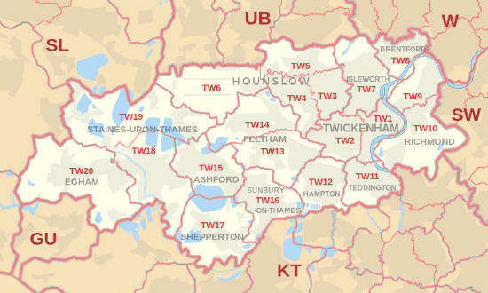
The coverage of the postcode districts, naming all localities[n 2] :
| Postcode district | Post town | Coverage | Local authority area |
|---|---|---|---|
| TW1 | TWICKENHAM | Twickenham, St. Margarets, Strawberry Hill (east) | Hounslow, Richmond upon Thames |
| TW2 | TWICKENHAM | Twickenham[n 3], Whitton, Strawberry Hill (west), Fulwell (north) | Richmond upon Thames |
| TW3 | HOUNSLOW | Hounslow, Lampton, Whitton (north) | Hounslow, Richmond upon Thames |
| TW4 | HOUNSLOW | Hounslow West, Hounslow Heath, Whitton (west), Cranford (south) | Hounslow, Richmond upon Thames |
| TW5 | HOUNSLOW | Heston, Cranford (north), Osterley (west) | Hounslow |
| TW6 | HOUNSLOW | Heathrow Airport | Hillingdon |
| TW7 | ISLEWORTH | Isleworth, Osterley (east and centre) | Hounslow |
| TW8 | BRENTFORD | Brentford, Kew Bridge, Syon Park | Hounslow |
| TW9 | RICHMOND | Richmond, Kew, North Sheen (north) | Richmond upon Thames |
| TW10 | RICHMOND | Ham, Petersham, Richmond Hill, North Sheen (south), Richmond Park | Kingston upon Thames, Richmond upon Thames |
| TW11 | TEDDINGTON | Teddington, Fulwell (east), Bushy Park | Richmond upon Thames |
| TW12 | HAMPTON | Hampton, Hampton Hill, Fulwell (west) | Richmond upon Thames |
| TW13 | FELTHAM | Feltham, Hanworth | Hounslow, Richmond upon Thames |
| TW14 | FELTHAM | Feltham (part of the station area), North Feltham, East Bedfont, Hatton | Hounslow, Hillingdon, Spelthorne |
| TW15 | ASHFORD | Ashford | Hounslow, Spelthorne |
| TW16 | SUNBURY-ON-THAMES | Sunbury-on-Thames | Elmbridge, Richmond upon Thames, Spelthorne |
| TW17 | SHEPPERTON | Shepperton, Upper Halliford, Charlton, Littleton | Elmbridge, Spelthorne |
| TW18 | STAINES-UPON-THAMES | Staines-upon-Thames, Egham Hythe, Laleham | Runnymede, Spelthorne, Windsor and Maidenhead |
| TW19 | STAINES-UPON-THAMES[3] | Stanwell, Stanwell Moor, Wraysbury, Sunnymeads, Hythe End | Hillingdon, Spelthorne, Windsor and Maidenhead |
| TW20 | EGHAM | Egham, Englefield Green, Thorpe | Runnymede |
Map
See also
Notes and References
- Notes
- References
- ↑ "ONS Postcode Directory Version Notes" (ZIP). National Statistics Postcode Products. Office for National Statistics. February 2012. Table 2. Retrieved 21 April 2012. Coordinates from mean of unit postcode points, "Code-Point Open". OS OpenData. Ordnance Survey. February 2012. Retrieved 21 April 2012.
- ↑ Royal Mail, Address Management Guide, (2004)
- ↑ Formerly "STAINES". "New sectors and localities to 20 July 2012" (PDF). Royal Mail Address Management Unit. 20 July 2012. Retrieved 18 August 2012.