Smiths Mill, Minnesota
| Smiths Mill, Minnesota | |
|---|---|
| Unincorporated community | |
 Smiths Mill, Minnesota  Smiths Mill, Minnesota Location of the community of Smiths Mill | |
| Coordinates: 44°08′16″N 93°46′05″W / 44.13778°N 93.76806°WCoordinates: 44°08′16″N 93°46′05″W / 44.13778°N 93.76806°W | |
| Country | United States |
| State | Minnesota |
| County | Blue Earth and Waseca |
| Township | Le Ray Township and Janesville Township |
| Elevation | 1,063 ft (324 m) |
| Time zone | Central (CST) (UTC-6) |
| • Summer (DST) | CDT (UTC-5) |
| ZIP code | 56048 and 56024 |
| Area code(s) | 507 |
| GNIS feature ID | 652188[1] |
Smiths Mill is an unincorporated community in Blue Earth and Waseca counties in the U.S. state of Minnesota. The community is located along 631st Avenue near 206th Street and U.S. Highway 14. Smiths Mill is located within Le Ray Township in Blue Earth County; and also located within Janesville Township in Waseca County. Nearby places include Janesville and Eagle Lake.
History
A post office called Smith's Mill was first established in 1876.[2] The community was named for Peter Smith, the owner of a mill.[3]
References
- ↑ "Smiths Mill, Minnesota". Geographic Names Information System. United States Geological Survey.
- ↑ "Waseca County". Jim Forte Postal History. Retrieved 28 March 2015.
- ↑ Chicago and North Western Railway Company (1908). A History of the Origin of the Place Names Connected with the Chicago & North Western and Chicago, St. Paul, Minneapolis & Omaha Railways. p. 125.
Municipalities and communities of Blue Earth County, Minnesota, United States | ||
|---|---|---|
| Cities | 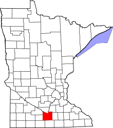 | |
| Townships | ||
| CDP | ||
| Unincorporated communities | ||
| Footnotes | ‡This populated place also has portions in an adjacent county or counties | |
Municipalities and communities of Waseca County, Minnesota, United States | ||
|---|---|---|
| Cities | 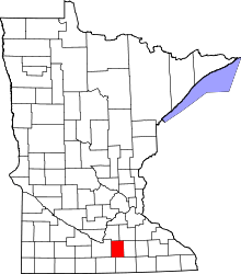 | |
| Townships | ||
| Unincorporated communities | ||
| Footnotes | ‡This populated place also has portions in an adjacent county or counties | |
This article is issued from Wikipedia - version of the 10/23/2016. The text is available under the Creative Commons Attribution/Share Alike but additional terms may apply for the media files.