Society Hill, Philadelphia
|
Society Hill Historic District | |
|
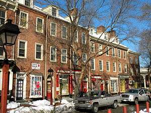
Head House Square on the 400 block of S. 2nd Street | |
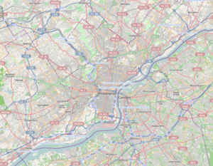   | |
| Location | Bounded on the N by Walnut St., on the S by Lombard St., on the E by pier line of Delaware River, and on the W by 8th, Philadelphia, Pennsylvania |
|---|---|
| Coordinates | 39°56′42″N 75°8′58″W / 39.94500°N 75.14944°WCoordinates: 39°56′42″N 75°8′58″W / 39.94500°N 75.14944°W |
| Area | 135 acres (55 ha) |
| Architect | multiple |
| Architectural style | Georgian, Federal, other |
| NRHP Reference # | 71000065[1] |
| Significant dates | |
| Added to NRHP | June 23, 1971 |
| Designated PRHP | March 10, 1999[2] |
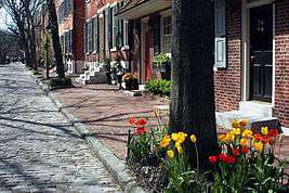
Society Hill is a neighborhood in the Center City section of Philadelphia, Pennsylvania. The neighborhood, loosely defined as bounded by Walnut, Lombard, Front and 8th Streets, contains the largest concentration of original 18th- and early 19th-century residential architecture of any place in the United States. Society Hill is noted as a charming district with cobblestone streets bordered by brick rowhouses in Federal and Georgian style.
History
The district is named after the 18th century Free Society of Traders, which had its offices at Front Street on the hill above Dock Creek. Located close to both the Delaware River and Philadelphia's civic buildings, including the Independence Hall, the neighborhood soon became one of the city's most populous areas. Several market halls, taverns and churches were built alongside brick houses of Philadelphia's affluent citizens. Dock Creek came to be the public sewer.
After the Revolutionary War, the city filled in the polluted Dock Creek, and created a new food distribution market on the street created by filling in the creek. Dock Creek became Dock Street. Though the streets of Philadelphia were carefully laid out in a grid, the new Dock Street’s arc connecting Chestnut and Spruce Streets between 2nd and 3rd, owes its uncharacteristic shape to the path of the former creek as it ran to the river.[3]
In the 19th century, the city expanded westward and the area lost its appeal. Houses deteriorated, and by the 1940s, Society Hill had become a slum neighborhood, one of the worst in the city.[4] In the 1950s, the city, state and federal governments began one of the first urban renewal programs aimed at the preservation of historic buildings. While most commercial 19th-century buildings were demolished, historically-significant houses were restored by occupants or taken over by the Philadelphia Redevelopment Authority and sold to individuals who agreed to restore the exteriors. Replicas of 18th-century street lights and brick sidewalks were added to enhance the colonial atmosphere. Empty lots and demolished buildings were replaced with parks, walkways, and modern townhouses. The Dock Street wholesale produce market was relocated to South Philadelphia.
From 1957-1959, the Greater Philadelphia Movement, the Redevelopment Authority and the Old Philadelphia Development Corporation bought 31 acres (130,000 m2) around Dock Street. They demolished and relocated the Dock Street market, setting aside 5 acres (20,000 m2) of land that would become the Society Hill Towers.[5]
In 1957, Edmund Bacon, the executive director of the Philadelphia City Planning Commission, awarded developer-architect firm Webb and Knapp the competition for the redevelopment of Society Hill. Architect I. M. Pei and his team designed a plan for three 31-story Society Hill Towers and low-rise buildings.[6] The Towers and townhouses project was completed in 1964, while the entire plan was completed in 1977.[7] Architect Louis Sauer designed dozens of rowhouse projects for the area around Society Hill, including Waverly Court and Penn's Landing Square.
Historic buildings in Society Hill include the Society Hill Synagogue, built in 1829 as a Baptist church by Philadelphia architect Thomas U. Walter, one of the architects of the United States Capitol in Washington, DC. The synagogue was entered into the National Register of Historic Places in 1971. Another notable building is St. Peter's Church, constructed between 1758 and 1761 by Robert Smith. Congregation Kesher Israel occupies and has renovated the building constructed by the Universalist Church in 1796 at 412 Lombard Street.
The Society Hill Historic District was listed on the National Register of Historic Places in 1971. In 1999, it was listed on the Philadelphia Register of Historic Places.[2]

Education
Society Hill residents are assigned to schools in the School District of Philadelphia. Residents are zoned to the General George A. McCall School, located in Society Hill,[8] for grades Kindergarten through 8,[9] and all persons zoned to McCall are assigned to Benjamin Franklin High School.[10] Previously Furness High School was the zoned high school for Society Hill.[11]
McCall serves Society Hill and the Chinatown areas.[12] The official opening of McCall occurred on February 1911; the construction of the building had been awarded on October 26, 1909.[13] By September 1998 the school, which had 650 students, established a bilingual English-Chinese program to serve Chinese immigrant students, and that month it began hiring teachers fluent in both languages to teach core subjects. At the time 25% of the students were Chinese, and the number of Chinese students had doubled in the previous two-year period.[12] Russell Scott Smith of Edutopia wrote that in 2004, compared with other School District of Philadelphia campuses, "McCall already had a fairly good reputation for academic rigor and safety" and that by 2009 it had improved even more.[14] In 2012 Kristen A. Graham of the Philadelphia Inquirer stated that McCall was one of "the district's stronger neighborhood schools".[15]
As of 2009 the racial percentages of McCall's student body were 55% Asian, 27% black, 11% white, 4% from other racial backgrounds, and 1.7% Hispanic and Latino. The school's parent-teacher organization is the McCall Home and School Association.[14] In 2012 about 50% of the student body was below the poverty line.[15] The school received a "cybrary", a library facility with 22 computers and materials in Mandarin Chinese, in 2007, financed by fundraisers and bake sales.[16] Its mandatory school uniform policy went into effect in 2001 when the school district required all schools to have strict dress codes.[17]
In 1993 the school district began a school bus route between Chinatown and McCall.[8] The school is 1.4 miles (2.3 km) away from the furthest point of Chinatown.[18] The district was not required to install the route, but parents advocated for the route because they believed that traffic at Market Street and Washington Square endangered their children. When the district proposed cutting the route in 1994, parents complained.[8]
Public library
The Free Library of Philadelphia operates the Independence Branch at 18 South 7th Street.[19]
Gallery
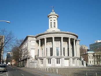 Merchants' Exchange Building, National Historic Landmark
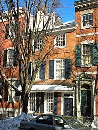 Drinker House at 241 Pine Street
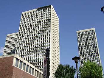

 Independence Branch Library
See also
- The Cassey House
- Benjamin Loxley house
- Bathsheba's spring and bower
- Independence National Historical Park
- National Register of Historic Places listings in Center City, Philadelphia
References
Notes
- ↑ National Park Service (2009-03-13). "National Register Information System". National Register of Historic Places. National Park Service.
- 1 2 "PRHP: List of historic districts". Philadelphia Historical Commission. Retrieved 03-12-2013. Check date values in:
|access-date=(help) - ↑ Perrine, William (January 27, 1919). "Dock Street". Evening Bulletin. Philadelphia. Retrieved 2016-01-21.
- ↑ Gallery, John Andrew, ed. (2004), Philadelphia Architecture: A Guide to the City (2nd ed.), Philadelphia: Foundation for Architecture, ISBN 0962290815, p.119
- ↑ Le Faivre-Rochester, Carole. "Society Hill Towers: A Bold and Graceful Venture." I.M. Pei and Society Hill: A 40th Anniversary Celebration. Ed. Herman Baron. Philadelphia: DIANE Publishing Co., 2003: 35. Google Books. .
- ↑ Perkins, Dorothy. "Biography of I.M. Pei." I.M. Pei and Society Hill: A 40th Anniversary Celebration. Ed. Herman Baron. Philadelphia: DIANE Publishing Co., 2003: 8. Google Books. .
- ↑ Le Faivre-Rochester, p. 36.
- 1 2 3 Jackson, Leigh. "SCHOOL BOARD TACK: SLASH, UNSLASH" (Archive). Philadelphia Daily News. May 28, 1994. 06 Local. Retrieved on November 8, 2011. - Article info
- ↑ "Gen. George A. McCall Elementary School Geographic Boundaries" (Archive). School District of Philadelphia. Retrieved on November 28, 2015.
- ↑ "High School Directory Fall 2017 Admissions" (Archive). School District of Philadelphia. p. 30/70. Retrieved on November 16, 2016.
- ↑ "Horace Furness High School Geographic Boundaries" (Archive). School District of Philadelphia. Retrieved on November 28, 2015.
- 1 2 Kadaba, Lini S. "An Effort To Speak To More Students The School District Is Extending The Reach Of Its Bilingual Programs." (Archive). Philadelphia Inquirer. October 6, 1998. Article info. B01 City & Region. Retrieved on November 29, 2015.
- ↑ "A Little Bit of History" (Archive). McCall Home and School Association. Retrieved on November 28, 2015.
- 1 2 Smith, Russell Scott. "Affluent Parents Return to Inner-City Schools for Educational Opportunities" (Archive). Edutopia. August 26, 2009. Retrieved on November 28, 2015.
- 1 2 Graham, Kristen A. "Organizers raise funds to offer free summer school" (Archive). Philadelphia Inquirer. July 12, 2012. Retrieved on November 28, 2015.
- ↑ Graham, Kristen A. "It clicks! Psyched about an elementary school's 'cybrary'" (Archive). Philadelphia Inquirer. January 8, 2007. Retrieved on November 28, 2015.
- ↑ Giordano, Rita. "Shift to mandatory dress policy fairly seamless in Phila. schools Students are nattily attired. Parents are just tired." (Archive). Philadelphia Inquirer. September 7, 2001. Retrieved on November 28, 2015.
- ↑ Jackson, Leigh. "Mccall Parents Want Bus From Chinatown, Kids Walk A Gantlet" (Archive). Philadelphia Inquirer. March 15, 1993. Retrieved on November 29, 2015.
- ↑ "Independence Branch." Free Library of Philadelphia. Retrieved on January 20, 2009.
External links
| Wikimedia Commons has media related to Society Hill, Philadelphia. |
- Society Hill Civic Association
- Society Hill Playhouse
- Historic Photographs of Society Hill, PhillyHistory.org
- Society Hill Magazine, a Guide to Society Hill and Historic Philadelphia
- General George A. McCall School
| Topics |   | |
|---|---|---|
| Lists by county |
| |
| Lists by city | ||
| Other lists | ||
| ||