South Goa district
| South Goa district दक्षिण गोंय जिल्हो | |
|---|---|
| District of Goa | |
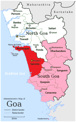 Location of South Goa district in Goa | |
| Country | India |
| State | Goa |
| Administrative division | N/A |
| Headquarters | Margão |
| Tehsils |
1.Salcete, 2.Mormugão, 3.Quepem, 4.Canacona, 5.Sanguem, 6.Dharbandora |
| Government | |
| • District collector | Swapnil Naik, I.A.S.[1] |
| • Lok Sabha constituencies | South Goa |
| Area | |
| • Total | 1,966 km2 (759 sq mi) |
| Population (2011) | |
| • Total | 639,962 |
| • Density | 330/km2 (840/sq mi) |
| Demographics | |
| • Literacy | 85.53% |
| • Sex ratio | 980 |
| Major highways |
1.National Highway 17, 2.National Highway 4A |
| Website | Official website |
South Goa is one of two districts that comprises the state of Goa in West India, within the region known as the Konkan. It is bounded by the district of North Goa to the north, the Uttara Kannada district of Karnataka state to the east and south, while the Arabian Sea forms its western coast.
The colours in the adjoining image:
Red: Velhas Conquistas (old Portuguese conquests)
Pink: Novo Conquistas (new Portuguese conquests)
Yellow: District Capital
History
The Portuguese established a colony in Goa in 1510 and expanded the colony to its present boundaries during the 17th and 18th centuries. Goa was annexed by India on 19 December 1961. Goa and two other former Portuguese enclaves became the union territory of Goa, Daman and Diu, and Goa was organised into a single district in 1965. On 30 May 1987 Goa attained statehood (while Daman and Diu became a separate union territory), and Goa was reorganised into two districts, North Goa and South Goa.
Administration
Dr. Sachin Shinde, an officer of the Indian Administrative Service, is the Collector and District Magistrate of South Goa.[2] There are Deputy Collectors and Mamlatdars for each Taluka.
The headquarters of the district is Margao.[3]
Divisions
The administrative headquarters of the district is Margao.
A spacious district administrative headquarters (Collectorate building) is located on the outskirts of Margao, adjoining the inter-city bus stand. It is named after Mathany Saldanha, a former minister and social activist.[4]
The district is divided into five subdivisions – Ponda, Mormugao (Vasco da Gama), Margao, Quepem, and Dharbandora; and seven taluks – Ponda, Mormugao, Salcete (Margao), Quepem, and Canacona (Chaudi), Sanguem, and Dharbandora.
Ponda Taluka shifted from North Goa to South Goa in January 2015.
Transport
Frequent buses are available between Margao and North Goa.
Demographics
According to the 2011 census South Goa has a population of 639,962[5] which is roughly equal to the nation of Montenegro[6] or the US state of Vermont.[7] This gives it a ranking of 515th in India (out of a total of 640). The district has a population density of 326 inhabitants per square kilometre (840/sq mi). Its population growth rate over the decade 2001-2011 was 8.63%. South Goa has a sex ratio of 980 females for every 1000 males, and a literacy rate of 85.53%.[5]
Konkani is the mother tongue of a majority of the people living in South Goa district. Marathi is spoken by a substantial number of people. English and Hindi are understood by a majority of the population. Portuguese is also spoken and understood by a small number of people.
Education
There are many educational institutions in South Goa. The prominent colleges include:
- Birla Institute of Technology and Science, Pilani – Goa Campus in Zuarinagar.
- The Parvatibai Chowgule College[8] in Margao.
- Carmel College for Women[9] in Nuvem.
- Govind Ramnath Kare College of Law [10] in Margao.
- Padre Conceicao College of Engineering (PCCE)[11] in Verna.
- Don Bosco College of Engineering[12] in Fatorda.
- Rosary College of Arts and Commerce[13] in Navelim.
- MES College[14] in Vasco da Gama.
- Shree Mallikarjun College[15] in Canacona.
- Shree Katyayani Baneshwar Vidyalaya [16] in Canacona.
References
- ↑ http://southgoa.nic.in/Collector.htm
- ↑ http://southgoa.nic.in/collectorate.htm
- ↑ http://southgoa.nic.in/profile.htm
- ↑ http://timesofindia.indiatimes.com/city/goa/South-Goa-collectorate-named-after-Matanhy/articleshow/20358438.cms
- 1 2 "District Census 2011". Census2011.co.in. 2011. Retrieved 2011-09-30.
- ↑ US Directorate of Intelligence. "Country Comparison:Population". Retrieved 2011-10-01.
Montenegro 661,807 July 2011 est.
- ↑ "2010 Resident Population Data". United States Census Bureau. Retrieved 2011-09-30.
Vermont 625,741
- ↑ http://59.165.134.221/chowgule/jsp/introduction/about_SPCC.jsp
- ↑ http://www.carmelcollegegoa.org/about_us.html
- ↑ http://www.grkarelaw.edu.in/aboutus.html
- ↑ http://www.pccegoa.org/
- ↑ http://www.dbcegoa.com/director.html
- ↑ http://rosarycollege.org/about/
- ↑ http://www.mescollege.org/index.php?option=com_content&view=article&id=1&Itemid=3
- ↑ http://www.shreemallikarjuncollege.in/
- ↑ http://www.publicinfopath.com/india/goa/31008-shri-katyayani-baneshwar/
External links
| Wikimedia Commons has media related to South Goa district. |
 |
North Goa district | | ||
| Arabian Sea | |
|||
| ||||
| | ||||
| Uttara Kannada district, Karnataka |
Coordinates: 15°16′21″N 73°57′30″E / 15.2724°N 73.9583°E