South San Francisco, California
| South San Francisco | |
|---|---|
| General law city[1] | |
| City of South San Francisco | |
|
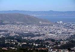
South San Francisco as viewed from a nearby ridge | |
| Nickname(s): South City; The Industrial City | |
 Location in San Mateo County and the state of California | |
 South San Francisco Location in the United States | |
| Coordinates: 37°39′22″N 122°25′32″W / 37.65611°N 122.42556°WCoordinates: 37°39′22″N 122°25′32″W / 37.65611°N 122.42556°W | |
| Country | United States |
| State | California |
| County | San Mateo |
| CSA | San Jose–San Francisco–Oakland |
| Metro | San Francisco–Oakland–Hayward |
| Incorporated | September 19, 1908[2] |
| Government | |
| • Mayor | Mark Addiego[3] |
| • Vice Mayor | Pradeep Gupta[3] |
| • City Manager | Mike Futrell[4] |
| • Councilmembers[3] |
Richard Garbarino, Karyl Matsumoto, and Liza Normandy |
| Area[5] | |
| • General law city[1] | 30.158 sq mi (78.109 km2) |
| • Land | 9.141 sq mi (23.674 km2) |
| • Water | 21.017 sq mi (54.435 km2) 69.69% |
| Elevation[6] | 16 ft (5 m) |
| Population (2010)[7] | |
| • General law city[1] | 63,632 |
| • Estimate (2014)[8] | 67,009 |
| • Density | 7,331/sq mi (2,831/km2) |
| • Metro | 4,594,060 (11th) |
| • CSA | 8,607,423 (5th) |
| Demonym(s) | South San Franciscan |
| Time zone | Pacific Time Zone (UTC−8) |
| • Summer (DST) | PDT (UTC−7) |
| ZIP codes | 94080, 94083, 94099 |
| Area code(s) | 650 |
| FIPS code | 06-73262 |
| GNIS feature IDs | 277618, 2411942 |
| Website |
www |
South San Francisco is a city in San Mateo County, California, United States, located on the San Francisco Peninsula in the San Francisco Bay Area. The population was 63,632 at the 2010 census.[7]
South San Francisco lies north of San Bruno and San Francisco International Airport in a small valley south of Daly City, Colma, Brisbane, and San Bruno Mountain, east of Pacifica and the hills of the Coast Range, and west of the waters of San Francisco Bay. Locals often refer to the town as South City, in much the same way that San Francisco is called "The City." Despite its name, South San Francisco does not border San Francisco, with Brisbane being between them.
Most of the valley faces San Francisco Bay, affording bay views from higher levels. South San Francisco has mild winters and dry cool summers. The hills to the west shield the city from much of the fog that prevails in neighboring areas.
The population has tripled since World War II with the opening of such subdivisions as Buri Buri, Winston Manor and Westborough on the slopes west of El Camino; it grew from 4,411 in 1920 to 67,009 in 2014.[8]
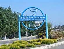
The city is noted for the South San Francisco Hillside Sign on Sign Hill, which rises to the north of the city, with large white letters that proclaim "South San Francisco, The Industrial City". The sign, a tribute to the city's industrial past, is listed on the National Register of Historic Places.[9]
History
The area which is now South San Francisco was originally part of Rancho Buri Buri, a large Mexican land grant dating to 1827. In 1853 Charles Lux and a business partner, Alfred Edmondson, purchased 1,700 acres (7 km2) of Rancho Buri Buri. Lux bought out Edmonson’s interest in 1856 and founded the town of Baden, now a neighborhood of South San Francisco. In 1855 Lux bought another 1,464 acres (6 km2) of Rancho Buri Buri land and became a partner of fellow San Francisco butcher and entrepreneur Henry Miller, forming the firm of Miller & Lux.[10]
The city of South San Francisco was originally conceived as an industrial suburb and was promoted by representatives of the Beef Trust, a group including some of the country's largest meat packing firms. A city plan was put forward in 1888 by Gustavus Franklin Swift, founder of the Swift & Company meat packing firm. The plan called for multiple individual meat-packing companies with a shared stockyard, as well as a residential area for employees. Swift proposed the name South San Francisco based on South Chicago and South Omaha, where the Swift company already had plants.
In 1890 Peter E. Iler of Omaha, Nebraska, an agent of the Beef Trust, purchased Lux's property, and in 1891 ownership was transferred to the South San Francisco Land and Improvement Company. The area was divided into industrial and residential districts, and the company installed lighting, sewer connections, and water distributions in the residential areas. A second corporation, eventually known as the Western Meat Company, set up stock yards and meat packing facilities on 80 acres (32 ha) of bayfront property; the facility opened in 1892. Other industries soon moved in, including a pottery works, two brick companies, the paint manufacturer W.P. Fuller & Company, the South San Francisco Lumber Company, and the Pacific Jupiter Steel Company.[9]
The city of South San Francisco was incorporated in 1908 following a dispute with San Mateo County, which had blocked the construction of a smelter on San Bruno Point which was supported by the locals.[9] Following incorporation additional industries moved into the town, including two steel mills. A new City Hall was opened on November 11, 1920.
By the 1920s the city was "the smokestack capital of the Peninsula."[11] South San Francisco proudly called itself "The Industrial City", a motto immortalized in 1923 by a huge sign on a hillside overlooking the city. Industry remained the city's main economic focus through the 1950s. During the depression the city maintained 35 industrial operations, including four meat-packing businesses, six iron or steel plants, a smelter for precious metals, seven equipment manufacturers of various kinds, two large paint factories, three other chemical works, and three food packing establishments. During World War II shipbuilding also became a significant operation.[9]
At the end of the war the city's focus shifted away from "smokestack industries" toward light industry, warehousing, and residential development. The major manufacturers closed, and new development was focused on office parks, housing, high-rise hotels, and yacht harbors. The biotechnology giant Genentech opened in 1976, leading to South San Francisco's new identity as "the birthplace of biotechnology".[12] The population grew to 63,632 as of the 2010 census.
Geography
South San Francisco is located at 37°39′22″N 122°25′32″W / 37.65611°N 122.42556°W (37.655983, -122.425525).[13]
According to the United States Census Bureau, the city has a total area of 30.2 square miles (78 km2), of which, 9.1 square miles (24 km2) of it is land and 21.0 square miles (54 km2) of it (69.69%) is water.
Climate
South San Francisco, along with most of the Bay Area, enjoys a mild Mediterranean climate (Köppen climate classification Csb), with warm, dry summers and cool, relatively wet winters. The micro climate of South San Francisco is dominated by wind from the nearby Pacific Ocean, which typically keeps the daytime temperatures quite cool year round, even during the summer months. January is the coolest month with August being the warmest month. The record highest temperature of 106 °F (41 °C) and was recorded on June 14, 1961. The record lowest temperature of 24 °F (-4.4 °C) was recorded on December 9, 1972.[14] The normal annual precipitation is 20.59 inches (52.3 cm).
| Climate data for South San Francisco, California | |||||||||||||
|---|---|---|---|---|---|---|---|---|---|---|---|---|---|
| Month | Jan | Feb | Mar | Apr | May | Jun | Jul | Aug | Sep | Oct | Nov | Dec | Year |
| Average high °F (°C) | 56 (13) |
60 (16) |
62 (17) |
65 (18) |
68 (20) |
71 (22) |
72 (22) |
73 (23) |
74 (23) |
70 (21) |
63 (17) |
57 (14) |
65.9 (18.8) |
| Average low °F (°C) | 44 (7) |
46 (8) |
48 (9) |
49 (9) |
52 (11) |
54 (12) |
55 (13) |
56 (13) |
56 (13) |
53 (12) |
49 (9) |
45 (7) |
50.6 (10.3) |
| Average precipitation inches (mm) | 4.17 (105.9) |
4.06 (103.1) |
2.95 (74.9) |
1.3 (33) |
0.47 (11.9) |
0.12 (3) |
0.00 (0) |
0.04 (1) |
0.16 (4.1) |
0.94 (23.9) |
2.36 (59.9) |
4.02 (102.1) |
20.59 (522.2) |
| Source: "US Climate Data[15] | |||||||||||||
South San Francisco is frequently windy. Summer is the windiest season with winds averaging 13.6 mph; winter is the least windy, with winds averaging 7.5 mph.[16]
| Month | Jan | Feb | Mar | Apr | May | Jun | Jul | Aug | Sept | Oct | Nov | Dec | Annual |
|---|---|---|---|---|---|---|---|---|---|---|---|---|---|
| Wind (mph) | 7.2 | 8.6 | 10.5 | 12.2 | 13.4 | 14.0 | 13.6 | 12.8 | 11.1 | 9.4 | 7.5 | 7.1 | 10.6 |
Demographics
| Historical population | |||
|---|---|---|---|
| Census | Pop. | %± | |
| 1910 | 1,989 | — | |
| 1920 | 4,411 | 121.8% | |
| 1930 | 6,193 | 40.4% | |
| 1940 | 6,629 | 7.0% | |
| 1950 | 19,351 | 191.9% | |
| 1960 | 39,418 | 103.7% | |
| 1970 | 46,646 | 18.3% | |
| 1980 | 49,393 | 5.9% | |
| 1990 | 54,312 | 10.0% | |
| 2000 | 60,552 | 11.5% | |
| 2010 | 63,632 | 5.1% | |
| Est. 2015 | 67,271 | [17] | 5.7% |
2000
As of the census of 2000, there were 60,552 people, 20,118 households, and 15,431 families residing in the city. The population density was 6,624.2 people per square mile (2,557.7/km²). There were 20,870 housing units at an average density of 2,283.1 per square mile (881.6/km²).
There were 20,118 households out of which 39.2% had children under the age of 18 living with them, 51.8% were married couples living together, 11.2% had a female householder with no husband present, and 28.5% were non-families. 21.9% of all households were made up of individuals and 8.0% had someone living alone who was 65 years of age or older. The average household size was 4.05 and the average family size was 4.51.
In the city the population was spread out with 25.2% under the age of 18, 11.2% from 18 to 24, 33.0% from 25 to 44, 22.0% from 45 to 64, and 11.6% who were 65 years of age or older. The median age was 33 years. For every 100 females there were 99.3 males. For every 100 females age 18 and over, there were 91.5 males.
The median income for a household in the city was $60,764, and the median income for a family was $65,598. Males had a median income of $41,742 versus $35,453 for females. The per capita income for the city was $25,562. About 5.5% of families and 6.2% of the population were below the poverty line, including 9.1% of those under age 18 and 5.7% of those age 65 or over.
South San Francisco is a middle class and working class city. However, that image is quickly changing as many luxury homes have been built, particularly at the foot of the mountain that divides Brisbane and South San Francisco, in the area in recent years to take advantage of the city's close proximity to downtown San Francisco, the bio-tech industry, and the peninsula. There are also developments of luxury condominiums in the Westborough district and on El Camino Real near the South San Francisco BART station.
The most commonly spoken language at home was English 43.13%, followed by Spanish 28.36%, Tagalog 11.48%, Chinese 3.4%, Hindi 1.5%, Arabic 1.59%, Cantonese 1.53%, Italian 1.47%, Vietnamese 0.67%, Russian 0.56%, Korean and Japanese 0.6% respectively, other languages were spoken by less than half of one percent of the population.[19]
2010
The 2010 United States Census[20] reported that South San Francisco had a population of 63,632. The population density was 6,961.2 people per square mile (2,687.8/km²). The racial makeup of South San Francisco was 23,760 (37.3%) White, 1,625 (2.6%) African American, 395 (0.6%) Native American, 23,293 (36.6%) Asian, 1,111 (1.7%) Pacific Islander, 9,598 (15.1%) from other races, and 3,850 (6.1%) from two or more races. Hispanic or Latino of any race were 21,645 persons (34.0%). Among the Hispanic population, 13,194 (20.7%) are Mexican, 571 (0.9%) are Puerto Rican, 92 (0.1%) are Cuban, and 7,788 (12.2%) are other Hispanic or Latino.
The Census reported that 63,053 people (99.1% of the population) lived in households, 528 (0.8%) lived in non-institutionalized group quarters, and 51 (0.1%) were institutionalized.
There were 20,938 households, out of which 7,588 (36.2%) had children under the age of 18 living in them, 11,165 (53.3%) were married couples, 2,897 (13.8%) had a female householder with no husband present, 1,268 (6.1%) had a male householder with no wife present. There were 1,083 (5.2%) unmarried couples, and 187 (0.9%) same-sex couples. 4,299 households (20.5%) were made up of individuals and 1,857 (8.9%) had someone living alone who was 65 years of age or older. The average household size was 3.01. There were 15,330 families (73.2% of all households); the average family size was 3.45.
The population was spread out with 13,787 people (21.7%) under the age of 18, 5,668 people (8.9%) aged 18 to 24, 18,645 people (29.3%) aged 25 to 44, 17,203 people (27.0%) aged 45 to 64, and 8,329 people (13.1%) who were 65 years of age or older. The median age was 38.1 years. For every 100 females there were 97.6 males. For every 100 females age 18 and over, there were 95.7 males.
There were 21,814 housing units at an average density of 2,386.4 per square mile (921.4/km²), of which 12,614 (60.2%) were owner-occupied, and 8,324 (39.8%) were occupied by renters. The homeowner vacancy rate was 1.3%; the rental vacancy rate was 4.0%. 37,802 people (59.4% of the population) lived in owner-occupied housing units and 25,251 people (39.7%) lived in rental housing units.
| Demographic profile[21] | 2010 |
|---|---|
| Total Population | 63,632 - 100.0% |
| One Race | 59,782 - 93.9% |
| Not Hispanic or Latino | 41,987 - 66.0% |
| Black or African American alone | 1,480 - 2.3% |
| American Indian and Alaska Native alone | 138 - 0.2% |
| Asian alone | 22,923 - 36.0% |
| Native Hawaiian and Other Pacific Islander alone | 1,054 - 1.7% |
| Some other race alone | 287 - 0.5% |
| Two or more races alone | 2,089 - 3.3% |
| Hispanic or Latino (of any race) | 21,645 - 34.0% |
| White (Non-Hispanic) | 16,226 - 25.5% |
Transportation
South San Francisco is adjacent to the San Francisco International Airport (SFO). A BART station, located directly adjacent to El Camino High School and Solaire Transit Village, provides rapid transit service to SFO, the city of San Francisco, and the East Bay. BART supplements the older Caltrain service to San Francisco and San Jose. Caltrain's station is adjacent to downtown on Grand Avenue.
On June 4, 2012, the Water Emergency Transportation Authority began a ferry service between Oyster Point Marina and the east bay cities of Oakland at Jack London Square and Alameda at the Main Street ferry terminal. The ferry service operates during weekday commute hours only.[22][23]
The city is served by several free shuttle services open to the general public:
- A South City Shuttle provides service between South San Francisco BART and the city's downtown. It includes trips to local stores, the senior center, libraries, city hall and parks. The shuttle provides transit connections with both BART and SamTrans.[24]
- A shuttle linking the South San Francisco Ferry Terminal to the Utah/Grand Ave office area operates during commute hours, Monday through Friday.[25]
- A shuttle linking the South San Francisco Ferry Terminal to the Oyster Point office area operates during commute hours, Monday through Friday.[26]
The city is served by two major north-south freeways, U.S. Route 101 (the Bayshore Freeway), along the San Francisco Bay, and Interstate 280, along the hills of the Santa Cruz Mountains.
Education
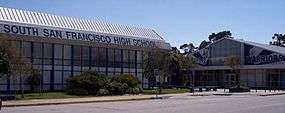
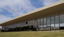
South San Francisco is part of the South San Francisco Unified School District, which also serves portions of the neighboring cities of Daly City and San Bruno. The city is home to two public high schools: El Camino High School and South San Francisco High School, which share a cross-town rivalry. Baden High School and South San Francisco Adult Education are the City's two continuation schools. The city also has three public middle schools: Parkway Heights, Westborough, and Alta Loma. These public high and middle schools, as well as a number of public elementary schools, and an adult school, South San Francisco Adult Education, are part of the South San Francisco Unified School District.
Several parochial schools are also established in the city: All Souls School, Mater Dolorosa School (recently closed), and St. Veronica's School.
The city is served by the Peninsula Library System.
Fire Department
South San Francisco Fire Department currently has five fire stations. Station 61 is home to Engine 61, Rescue 61, Battalion 17, and a basic life support ambulance. Station 62 is home to the brand new Quint 62. Station 63 is home to Engine and Rescue 63. It's nickname is "The Bunker". Station 64 is home to Engine 64. Station 65 is home to E65 and US&R 165 (Heavy Rescue) . By the city's terminology, an engine must have 3 crew members but most of the time it is staffed by only two people, therefore it is Squad 165. Urban Search and Rescue, or USAR 165 is stationed there. It is manned by on duty crew from around the city and is decided before every shift. Rescue Boat 62 is located at Oyster Point Marina and can be staffed by Q62 personnel if needed.[27]
Neighborhoods
The city's small downtown and several residential subdivisions, such as Mayfair Village, Sunshine Gardens, Avalon Park, Winston Manor, West Winston Manor, and Rancho Buri Buri, are located west of Highway 101, while the area east of Highway 101 is dominated by industrial complexes interspersed with modern office parks, particularly near the Oyster Point Marina on San Francisco Bay. The extreme western portions of the city near Interstate 280 sit along a hillside and offer views of San Francisco Bay. This area is known to local residents as Westborough. The southern part of the city, closest to the airport, is home to a large number of car repair shops, airport parking lots, and airport hotels.
Grand Avenue, from Chestnut to Airport, is considered downtown South San Francisco, with various small shops and restaurants. Grand Avenue is host to a plethora of stores, one of which is Bronstein Music, a well-known local music store that has been around since 1946. City Hall is located on Grand Avenue, which, to the residents of South City, is known simply as "Grand." Grand also runs perpendicular with one of the city's other well-known streets, Linden, which connects San Bruno to Highway 101. Chestnut Avenue connects Hillside, the northern bordering street at the foot of San Bruno Mountain, to Westborough Blvd, and subsequently to one of the neighborhoods known as Westborough.
South San Francisco consists of the following neighborhoods:
|
|
Paradise Valley is so named because it resides in between Sign Hill and San Bruno Mountain. Students mostly from Westborough and Buri Buri attend El Camino High School. The majority of Brentwood and Paradise Valley inhabitants attend South San Francisco High School, as well as the East Side inhabitants. The same inhabitants are also so-divided among Westborough Middle School, Alta Loma Middle School and Parkway Heights Middle School respectively.
Points of interest and recreation
Sign Hill
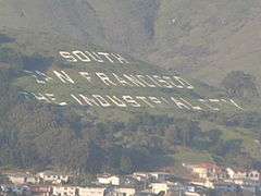
South San Francisco is not known as a tourist destination, but it is a key landmark visible to anyone who travels along the San Francisco Peninsula or through the nearby San Francisco International Airport. Sign Hill, near San Bruno Mountain State Park, displays huge letters on its mountainside [28] which reads "SOUTH SAN FRANCISCO THE INDUSTRIAL CITY." The letters are made of painted concrete and sit flush along the hillside (in contrast to the raised steel letters of the Hollywood Sign in Los Angeles). The sign was put up in the 1920s, and in 1996 was given a place in the National Register of Historic Places as an outstanding example of early 20th-Century "civic boosterism", a tribute to the past importance of heavy industry to the regional economy, and recognizing significant contributions the area made during World Wars I and II.
Sign Hill is now a city park which provides hikers with access to the letters; the park includes 30 acres (12 ha) of open space and almost 2 miles (3.2 km) of hiking trails.[29] At the top of Sign Hill, a tall pole with electric lights serves as an electric Christmas tree, which is typically lit from the day after Thanksgiving until January 6. The "tree" is visible for many miles at night. In 2008, the pole was modified to hold a vertical number 100, celebrating South San Francisco's 100th year as an incorporated city. For Memorial Day, Independence Day & Veterans Day, the pole flies an American flag. An airport weather-station is sited next to the flagpole.
Wind Harp
Originally called the Cabot, Cabot and Forbes Tower when it was constructed in 1967 as the centerpiece of their industrial park, this striking 92-foot-tall sculpture by Lucia and Aristides Demetrios is one of the world's largest aeolian harps.[30] Named for Aeolus, the Greek god of the wind, and invented by the 17th-century polymath Athanasius Kircher, an aeolian harp is a passive instrument played by the movement of the wind. Fabricated from steel manufactured at Bethlehem Steel. It was designed to “take advantage of the viewer’s motion… constantly changing, presenting a series of graceful ellipses and a shifting light pattern.”[31]
City Hall
City Hall is located at 400 Grand Avenue. The City purchased the Civic Center site in 1913 for $10,000 from the South San Francisco Land and Improvement Company. This property had been marked for nineteen prime home sites. The City Hall design was modeled after Philadelphia's Independence Hall's neo-colonial Georgian design. The City's Mayoral Office, City Manager's Office, City Clerk, Economic and Community Development, Finance and Human Resources services are located in City Hall.
Other parks
South San Francisco has a number of other parks: Orange Memorial Park offers baseball/softball fields, soccer fields, indoor swimming, picnic grounds, a sculpture garden, children's play equipment, tennis courts, basketball courts, bocce ball, and a newly created skate park. It hosts a Saturday farmer's market (May–October), as well as the annual "South San Francisco Day in the Park" in September. Alta Loma Park, Buri-Buri Park, Monte Verde Park, Paradise Valley, Sellick Park, and Westborough Park all include facilities for sports as well as picnics, and the Terrabay Recreation Center has an excellent gymnasium. SSF Unified School District facilities are also available for sports, and the Boys and Girls Club of Northern San Mateo County is headquartered adjacent to Orange and Centennial Parks.
The city also has a park and marina along the shore of San Francisco Bay, named Oyster Point, which is also home to the private Oyster Point Yacht Club. South San Francisco has walkways and bike trails adjacent to the San Francisco Bay, from which runners are able to view San Francisco International Airport operations, while wind-surfers and kayakers may launch their watercraft. South San Francisco is home to many hotels as well, since it is close to San Francisco and actually directly next to SFO.
A unique opportunity was created when BART expanded down the Peninsula to create a "linear park" on the swath of undeveloped land on top of the tube. Running from Colma to Millbrae, South San Francisco's portion is three miles long, running through the center of town from the South San Francisco BART Station to the San Bruno BART Station. The Class I bicycle and pedestrian trail is a 10" wide asphalt pathway with 2' decomposed granite shoulders, irrigated for low-maintenance landscaping, with safety lighting, signalized intersections where the trail crosses Spruce and Chestnut Avenues, and in-ground flashing lights at Orange Avenue. Also, a dog park is located adjacent from Orange Park along the pathway. The new park is called Centennial Way to commemorate the City's 100th birthday in 2008.
Other places of interest
The downtown area along Grand Avenue has buildings from the city's earliest days. Galli's Sanitary Bakery has been in business since 1909, while – a few blocks down – the 1905 Plymire-Schwartz house was the North Peninsula's first hospital; it is now operated by the Historical Society (which also has a Historical Society Museum in the old California Water Service Company administration building at 80 Chestnut Avenue). The 1920 city hall is modelled after Independence Hall in Philadelphia, while next to it sits the original 1916 Carnegie Library. The 1912 Metropolitan Hotel (built by the Meat Packers Consortium) now has a mural depicting SSF History high on its east wall. Bertolucci's is an Italian restaurant that has also been around almost since the birth of the city, located in close proximity to downtown South San Francisco and is easily seen from highway 101. Fine WPA murals of SSF may be seen in the Linden Avenue Post Office and the Grand Avenue library.
The South San Francisco Public Library (part of the Peninsula Library System) has served the city since 1917 with branches in the Grand Avenue civic center and on West Orange Avenue just off of Westborough.
The South San Francisco Farmers Market is at Orange Memorial Park from May through October, 9am to 1pm. The market offers only California-grown products sold directly to consumers.
Every Holiday season residents of Parkway Estates (a three-street development built in the mid-1980s off Chestnut Avenue) decorate their houses and yards with Christmas lights. This display is open to the public, is well-known holiday attraction, and hundreds of visitors arrive every holiday season. Lilac Lane (off of Palm Avenue) was an earlier seasonal decoration cooperative which began in the 1960s, at one point it was the destination of the city's Santa Claus parade, and the spot where the local Chamber of Commerce Santa passed out toys from R.Dakin (formerly headquartered in SSF) to hundreds of children. Few of the original residents survive and decorative technology today has far surpassed the 60's era so, in the 21st century, Lilac Lane has become a backwater.
South San Francisco has one bowling alley named Brentwood Bowl due to its proximity to the Brentwood Neighborhood on El Camino Real. The city is home to the private California Golf & Country Club, next to its public library, bounded by Ponderosa Road and Westborough.
Economy

Much of what is now South San Francisco was initially agricultural land, and was originally known as Baden. Small pockets of farmland still exist near San Bruno Mountain, but these lands are disappearing quickly due to the City Council yielding to developers' demands. Acres of Orchids, founded by the Rod McLellan Company in the late 1920s, was one such victim of housing development. Once one of the largest facilities in the United States producing orchids and gardenias, the nursery closed in 1998.[32] A new housing tract now sits upon the land formerly occupied by Acres of Orchids greenhouses, off El Camino near Hickey.
The flat land east of Bayshore Freeway (US 101) is the R&D Campus of South San Francisco and carries on the tradition of the moniker on Sign Hill, "The Industrial City." South San Francisco's office parks and industrial zoning are favorable to meet needs of industry, and the property taxes levied from the extensive industrial park provide revenues for the city. South San Francisco is home to one Fortune 500 company, food wholesaler Core-Mark.
South San Francisco is home to Genentech, one of the world's largest biotech companies, as well as a satellite office of Amgen, the world's largest biotech firm. Many other biotech companies, such as Exelixis, have also started or moved to South San Francisco to be in proximity to UCSF, Stanford University, and UC Berkeley; all are within an hour's drive. A sign located on East Grand Avenue declares South San Francisco as the "Birthplace of Biotechnology."[33]
The headquarters and factory of See's Candies is located in South San Francisco.[34] Air China operates an office in South San Francisco.[35]
Galoob had its headquarters in South San Francisco before Hasbro bought the company in 1998.[36] Hudson Soft USA, a subsidiary of Hudson Soft, and Sanrio, Inc., had its headquarters in South San Francisco.[37] SuccessFactors, a multinational, cloud-based human capital management solution company is headquartered in South San Francisco.
Top employers
According to the City's Comprehensive Annual Financial Report Fiscal Year 2013/2014,[38] the top employers in the city are:
| # | Employer | # of Employees |
|---|---|---|
| 1 | Genentech | 7,945 |
| 2 | Onyx Pharmaceuticals | 650 |
| 3 | Thermo Fisher Scientific | 600 |
| 4 | Costco Wholesalers (2 stores) | 510 |
| 5 | Amgen | 406 |
| 6 | Successfactors, Inc | 400 |
| 7 | Royal Laundry | 284 |
| 8 | The New French Bakery | 281 |
| 9 | Oroweat/Entenmann's | 264 |
| 10 | Theravance Biopharma | 258 |
Government
The city is governed by a five-member City Council, with one of the five council members serving as Mayor for one year in a rotation among the other council members. Council members serve a four-year elected term, all running at-large. As of 2016 the Council is composed of Mayor Mark Addiego;[39] Vice-Mayor Pradeep Gupta; Council member Karyl Motsumoto;[39] Council member Richard Garbarino; and Council member Liza Normandy. The City Manager is Mike Futrell.[40]
In the California State Legislature, South San Francisco is in the 13th Senate District, represented by Democrat Jerry Hill, and in the 22nd Assembly District, represented by Democrat Kevin Mullin.[41]
In the United States House of Representatives, South San Francisco is in California's 14th congressional district, represented by Democrat Jackie Speier.[42]
Sister cities
South San Francisco has five sister cities:[43]
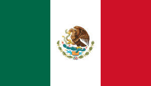 Atotonilco, Mexico
 Kishiwada, Japan
 Lucca, Italy
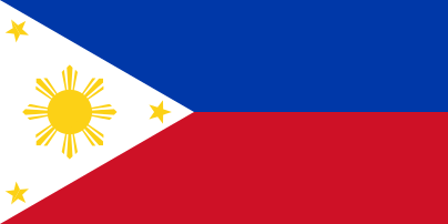 Pasig City, Philippines
 Saint-Jean-Pied-de-Port, France
See also
South San Francisco Official Website: www.ssf.net
References
- 1 2 3 "Elections". South San Francisco. Retrieved February 10, 2015.
- ↑ "California Cities by Incorporation Date" (Word). California Association of Local Agency Formation Commissions. Retrieved August 25, 2014.
- 1 2 3 "City Council". South San Francisco. Retrieved January 1, 2016.
- ↑ "City Manager". South San Francisco. Retrieved December 30, 2014.
- ↑ "2010 Census U.S. Gazetteer Files – Places – California". United States Census Bureau.
- ↑ "South San Francisco". Geographic Names Information System. United States Geological Survey. Retrieved November 23, 2014.
- 1 2 "American FactFinder". United States Census Bureau. Retrieved 2014-11-21.
- 1 2 "Annual Estimates of the Resident Population for Incorporated Places: April 1, 2010 to July 1, 2014". Retrieved June 4, 2015.
- 1 2 3 4 "National Register of Historic Places Continuation Sheet" (PDF). National Park Service. Retrieved April 2, 2013.
- ↑ Igler, David; Hero & Ethel Rensch, and William N. Abeloe (2001). Industrial cowboys: Miller & Lux and the Transformation of the Far West, 1850-1920. University of California Press. ISBN 978-0-520-22658-6. Cite uses deprecated parameter
|coauthors=(help) - ↑ Simon, Mark (May 7, 1996). "South S.F. Sign Wins Status; Famous hillside slogan to be historic landmark". San Francisco Chronicle. Retrieved April 3, 2013.
- ↑ Pellissier, Hank (November 6, 2010). "Local Intelligence: Sign Hill". The New York Times. Retrieved April 3, 2013.
- ↑ "US Gazetteer files: 2010, 2000, and 1990". United States Census Bureau. 2011-02-12. Retrieved 2011-04-23.
- ↑ http://www.intellicast.com/Local/History.aspx?month=12
- ↑ "1981–2010 Monthly Climate Summary". US Climate Data. May 2015. Retrieved May 28, 2015.
- ↑ http://wind-speed.weatherdb.com/l/43/South-San-Francisco-California
- ↑ "Annual Estimates of the Resident Population for Incorporated Places: April 1, 2010 to July 1, 2015". Retrieved July 2, 2016.
- ↑ "Census of Population and Housing". Census.gov. Retrieved June 4, 2015.
- ↑ MLA, South San Francisco entry, retrieved November 13, 2007
- ↑ "2010 Census Interactive Population Search: CA - South San Francisco city". U.S. Census Bureau. Retrieved July 12, 2014.
- ↑ "Demographic Profile Bay Area Census".
- ↑ Route. San Francisco Bay Ferry (2013-04-29). Retrieved on 2013-07-21.
- ↑ New South San Francisco Service Launches June 4, 2012. San Francisco Bay Ferry (2012-06-04). Retrieved on 2013-07-21.
- ↑ South City Shuttle
- ↑ Ferry to Grand shuttle
- ↑ Ferry to Oyster Point shuttle
- ↑ South San Francisco - Official Website - Stations. Ca-southsanfrancisco.civicplus.com. Retrieved on 2013-07-21.
- ↑ Google Maps. Maps.google.com (1970-01-01). Retrieved on 2013-07-21.
- ↑ "Sign Hill". City of South San Francisco. Retrieved April 2, 2013.
- ↑ "Atlas Obscura: LUCIA AND ARISTIDES DEMETRIOS WIND HARP". Retrieved July 1, 2015.
- ↑ "Images of America: South San Francisco by South San Francisco Historical Society". Arcadia Publishing. Retrieved July 1, 2015.
- ↑ Matters Historical: Dominating county's nursery business
- ↑ Perrigan, Dana."Proud of past, South San Francisco looks ahead","The San Francisco Chronicle", February 15, 2009, accessed July 26, 2011.
- ↑ "About Us." See's Candies. Retrieved on January 18, 2009.
- ↑ "International Offices." Air China. Retrieved on January 18, 2009.
- ↑ Fost, Dan. "Hasbro Adds Galoob to Its Toy Chest." San Francisco Chronicle. Tuesday September 29, 1998. Retrieved on April 25, 2010.
- ↑ "KIDS' GIFTS: A NINTENDO NIGHTMARE BAD-BOY VIDEO GAMES HAVE PARENTS, MAKERS TALKING MODERATION." San Jose Mercury News. December 20, 1992. 1A Front. Retrieved on July 12, 2010. "Hudson Soft USA Inc. of South San Francisco..."
- ↑ City of South San Francisco Comprehensive Annual Financial Report, Year Ended June 30, 2014 Retrieved 2011-04-30
- 1 2 "San Mateo Daily Journal". www.smdailyjournal.com. Retrieved 2015-12-01.
- ↑ "San Mateo Daily Journal". www.smdailyjournal.com. Retrieved 2015-12-01.
- ↑ "Statewide Database". UC Regents. Retrieved November 20, 2014.
- ↑ "California's 14th Congressional District - Representatives & District Map". Civic Impulse, LLC. Retrieved March 12, 2013.
- ↑ "Interactive City Directory". Sister Cities International. Retrieved December 30, 2014.
External links
| Wikimedia Commons has media related to South San Francisco, California. |
 South San Francisco travel guide from Wikivoyage
- Official website
- South San Francisco Chamber of Commerce
- City data guide to SSF
Municipalities and communities of San Mateo County, California, United States | ||
|---|---|---|
| Cities and towns | 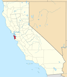 | |
| CDPs | ||
| Unincorporated communities | ||
| Ghost towns | ||
| Bodies of water |
|  |
|---|---|---|
| Counties | ||
| Major cities | ||
| Cities and towns 100k–250k | ||
| Cities and towns 50k–99k | ||
| Cities and towns 25k-50k | ||
| Cities and towns 10k–25k |
| |
| Sub-regions | ||