Stone Arch Bridge (Champaign, Illinois)
|
Stone Arch Bridge | |
|
(2012) | |
  | |
| Location |
near Springfield Ave. and 2nd St. Champaign, Illinois |
|---|---|
| Coordinates | 40°6′46″N 88°14′14″W / 40.11278°N 88.23722°WCoordinates: 40°6′46″N 88°14′14″W / 40.11278°N 88.23722°W |
| Area | 0.1 acres (0.040 ha) |
| Built | 1860 |
| NRHP Reference # | 81000210[1] |
| Added to NRHP | May 14, 1981 |
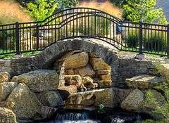
The Stone Arch Bridge, located near the intersection East Springfield Avenue and South Second Street in Champaign, Illinois was built in 1860. In c.2010, it was integrated into the design of the Boneyard Creek Second Street Basin, a flood control facility and recreational amenity which is located between First and Second Streets and Springfield and University Avenues.[2]
The bridge was listed on the National Register of Historic Places in 1981.[1]
References
Notes
- 1 2 National Park Service (2009-03-13). "National Register Information System". National Register of Historic Places. National Park Service.
- ↑ "Boneyard Second Street Detention Project" on the City of Champaign website
External links
 Media related to Stone Arch Bridge (Champaign, Illinois) at Wikimedia Commons
- Tour of Boneyard Creek Phase 2 Improvements on Picasa, see in particular, photos 7 and 8
- National Register nomination
| People |  | |
|---|---|---|
| History and government | ||
| Education | ||
| Cultural places and events |
| |
| Public transportation | ||
| Interstates and highways | ||
| ||
| Topics | |
|---|---|
| Lists by states |
|
| Lists by insular areas | |
| Lists by associated states | |
| Other areas | |
| |
This article is issued from Wikipedia - version of the 11/29/2016. The text is available under the Creative Commons Attribution/Share Alike but additional terms may apply for the media files.