Sturgeon County
| Sturgeon County | |
|---|---|
| Municipal district | |
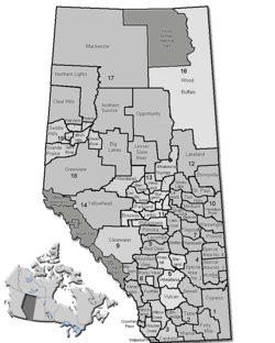 Location of Sturgeon County in Alberta | |
| Coordinates: 53°48′8″N 113°38′59″W / 53.80222°N 113.64972°WCoordinates: 53°48′8″N 113°38′59″W / 53.80222°N 113.64972°W | |
| Country | Canada |
| Province | Alberta |
| Region | Edmonton Capital Region |
| Census division | No. 11 |
| Established | 1955 |
| Incorporated | 1997 (County) |
| Government[1] | |
| • Mayor | Tom Flynn |
| • Governing body |
Sturgeon County Council
|
| • CAO | Peter Tarnawsky |
| • Office location | Morinville |
| Area (2011)[2] | |
| • Total | 2,088.55 km2 (806.39 sq mi) |
| Population (2011)[2] | |
| • Total | 19,578 |
| • Density | 9.4/km2 (24/sq mi) |
| • Dwellings | 6,302 |
| Time zone | MST (UTC-7) |
| Website |
sturgeoncounty |
Sturgeon County is a municipal district in Alberta's Edmonton Capital Region, Canada.
It begins at the north end of Edmonton, with 97th street turning into Highway 28. It extends east to Fort Saskatchewan and west to Calahoo. It is located in Division No. 11.
The county was incorporated in the current boundaries in 1955, as Municipal District of Sturgeon River No. 90. It first achieved county status in 1961, was subsequently disorganized, then established as a county again in 1997. It was named for the Sturgeon River.
Historically, the region was a part of a large ethnic block settlement of French-speaking Albertans. Today the county is less than 5% francophone. The area was first settled in 1879.[3]
Demographics
In the 2011 Census, Sturgeon County had a population of 19,578 living in 6,546 of its 6,915 total dwellings, a 5.5% change from its 2006 adjusted population of 18,566. With a land area of 2,088.55 km2 (806.39 sq mi), it had a population density of 9.4/km2 (24.3/sq mi) in 2011.[2]
The population of Sturgeon County according to its 2008 municipal census is 19,165.[4]
In 2006, Sturgeon County had a population of 18,621 living in 6,302 dwellings, a 3.1% increase from 2001. The municipal district has a land area of 2,108.90 km2 (814.25 sq mi) and a population density of 8.8/km2 (23/sq mi).[5]
In 2001, Sturgeon County had a population of 18,067.[6]
Communities and localities
The following urban municipalities are surrounded by Sturgeon County:[7][8]
The following localities are located within Sturgeon County:[9]
- Localities
- Amelia
- Austin Acres
- Banko Junction
- Braun Village
- Cameron Park
- Cardiff-Echoes
- Cardiff-Pittsburgh
- Casa Vista
- Clearview Acres
- Coronado
- Crestview Heights
- Dover Estates
- Dream Hollow Estates
- Dream Nook
- Duagh
- Eastgate
- Eldorena
- Excelsior
- Fairhaven East Subdivision
- Fairhaven West Subdivision
- Fairydell
- Fedorah
- Fort Augustus
- Fort Saskatchewan Settlement
- Freemore Estates
- Gibbons Lea
- Gibbons Station
- Glenview
- Glory Hills (designated place) or Glory Hills Development
- Golden Heights
- Grandview Heights
- Greenacres Estates
- Hansen Subdivision
- Hanson Subdivision
- Hewitt Estates (designated place)
- Hillsborough Estates
- Hu Haven (designated place)
- Juniper Hill
- Lancaster Park
- Lily Lake Estates
- Lower Manor Estates (designated place)
- MacArthur Siding
- Manor Estates
- Maple Ridge
- Namao (designated place, different than the hamlet of the same name)
- Namao Ridge Estates
- Sturgeon Valley Estates
- New Lunnon
- Noroncal
- North Point
- Nywening
- Osthoff Estates
- Peavey
- Pilon Creek Estates
- Pinewood Estates
- Regency Estates
- Reyda Vista Subdivision
- Richfield Estates
- Riverside Park
- Riviere Qui Barre
- Rol-Ana Park
- Rosal Acres
- Shil Shol
- Silverchief Subdivision
- Skyglen
- St. Albert Settlement
- Sturgeon
- Sturgeon Creek Subdivision
- Sturgeon Crest Subdivision
- Sturgeon Heights
- Sturgeon Valley Vista
- Sturgeon View Estates
- Summer Brook
- Summerbrook Estates
- Trestle Ridge
- Turfside Park
- Upper Manor Estates (designated place)
- Upper and Lower Viscount Estates (designated place)
- Lower Viscount Estates or Lower Viscount
- Upper Viscount Estates or Upper Viscount Estates Subdivision
- Volmer
- Waterdale Park
- Waybrook
- Wildlife Park
- Woodridge Estates
- Other places
See also
References
- ↑ "Municipal Officials Search". Alberta Municipal Affairs. December 16, 2016. Retrieved December 18, 2016.
- 1 2 3 "Population and dwelling counts, for Canada, provinces and territories, and census subdivisions (municipalities), 2011 and 2006 censuses (Alberta)". Statistics Canada. 2012-02-08. Retrieved 2012-02-08.
- ↑ Speers, Bertha (1936). A cameo of the West : story of the pioneers of the Sturgeon River district, 1879-1900. Namao, Alberta: UFWA.
- ↑ Alberta Municipal Affairs (2009-09-15). "Alberta 2009 Official Population List" (PDF). Retrieved 2010-09-12.
- ↑ Statistics Canada. "Canada 2006 Census: Sturgeon County - Community Profile". Retrieved 2007-06-11.
- ↑ Sturgeon County community profile - Statistics Canada. 2002. 2001 Community Profiles. Released June 27, 2002. Last modified: 2005-11-30. Statistics Canada Catalogue no. 93F0053XIE.
- ↑ "St. Albert, City (Census Subdivision), Alberta". Statistics Canada. 2012-06-20. Retrieved 2012-08-13.
- 1 2 "Specialized and Rural Municipalities and Their Communities" (PDF). Alberta Municipal Affairs. 2012-03-01. Retrieved 2012-08-12.
- ↑ "Standard Geographical Classification (SGC) 2006, Economic Regions: 4811059 - Sturgeon County, geographical codes and localities, 2006". Statistics Canada. 2010-03-05. Retrieved 2012-08-12.
External links
 |
County of Barrhead No. 11 | Westlock County | Thorhild County | |
| Lac Ste. Anne County | |
Lamont County | ||
| ||||
| | ||||
| Parkland County | City of Edmonton | Strathcona County |