Tochigi, Tochigi
| Tochigi 栃木市 | |||
|---|---|---|---|
| City | |||
|
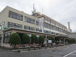
Tochigi City Hall | |||
| |||
 Location of Tochigi in Tochigi Prefecture | |||
 Tochigi
| |||
| Coordinates: 36°22′52.8″N 139°43′49″E / 36.381333°N 139.73028°ECoordinates: 36°22′52.8″N 139°43′49″E / 36.381333°N 139.73028°E | |||
| Country | Japan | ||
| Region | Kantō | ||
| Prefecture | Tochigi Prefecture | ||
| Government | |||
| • Mayor | Toshimi Suzuki (since April 2010) | ||
| Area | |||
| • Total | 331.50 km2 (127.99 sq mi) | ||
| Population (December 2015) | |||
| • Total | 159,648 | ||
| • Density | 482/km2 (1,250/sq mi) | ||
| Time zone | Japan Standard Time (UTC+9) | ||
| - Tree | Japanese stuartia | ||
| - Flower | Japanese azalea | ||
| Phone number | 0282-21-2224 | ||
| Address | 7-26 Irifune, Tochigi-shi, Tochigi-ken 328-8686 | ||
| Website | Official website | ||


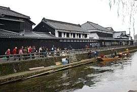
Tochigi (栃木市 Tochigi-shi) is a city located in Tochigi Prefecture, in the northern Kantō region of Japan. As of May 2015, the city had an estimated population of 159,648 and a population density of 482 persons per km². Its total area was 331.50 square kilometres (127.99 sq mi). Because the city escaped war damage during World War II, many historical temples, traditional shops and kura (Japanese traditional storehouses) remain in the city center. The city was awarded the "Utsukushii-machinami Taisho" prize from the Ministry of Land, Infrastructure, Transport and Tourism in 2009.[1]
Geography
Tochigi is located in the very southern portion of Tochigi Prefecture, bordering on Ibaraki Prefecture and Gunma Prefecture to the southwest. In the southern part of the city the Yanaka Reservoir, which is in the Watarase flood control area, is used for sailboating and windsurfing. It was designated a Ramsar Site in June 2012.[2]
Surrounding municipalities
History
In the Edo period Tochigi prospered from its location on the Uzumagawa River, which connected with the Tone River to Edo. Envoys using the Reiheishi Way sent from the Imperial Court going to Shrines and Temples of Nikkō stayed at the lodging area in the city. Most the area was formerly tenryo territory controlled directly by the Tokugawa shogunate; however, the minor feudal domain of Fukiake Domain was located within the borders of modern city of Tochigi.
Following the Meiji restoration and the creation of Tochigi Prefecture, Tochigi Town was the prefectural capital from 1871 until its relocation to Utsunomiya in 1884. On April 1, 1937 Tochigi was elevated to city status.
On September 30, 1954 Tochigi absorbed the villages of Ōmiya, Minagawa, Fukiage and Terao (all from Shimotsuga District). This was followed by the village of Kōō (from Shimotsuga District) on March 31, 1957. Tochigi hosted its first film festival, the Kuranomachikado, or, "Eizo Film Festival" from 5 October 2007 to 8 October 2007. On March 29, 2010, Tochigi absorbed the towns of Fujioka, Ōhira and Tsuga (Shimotsuga District). This was followed by the town of Nishikata (from Kamitsuga District) on October 1, 2011 and the town of Iwafune (from Shimotsuga District) on April 5, 2014.
Economy
Tochigi city is a regional commercial center, and has a mixed local economy. Food processing, automotive parts and light manufacturing dominated the industrial sector. Isuzu has maintained a factory since 1961. In 2010, the city ranked first in the number of farming families in the prefecture.[3]
Education
- Kokugakuin Tochigi Junior College
- Tochigi also has 31 primary schools, 15 middle schools and eight high schools.
Transportation
Railway
- JR East – Ryōmō Line
- Tochigi - Ōhirashita - Iwafune
- Tobu Railway – Tobu Nikko Line
- Fujioka - Shizuwa - Shin-Ōhirashita - Tochigi - Shin-Tochigi - Kassemba - Ienaka - Tōbu Kanasaki
- Tobu Railway – Tobu Utsunomiya Line
Highway
- Tōhoku Expressway – Sano-Fujioka IC, Iwafune JCT, Tochigi IC, Tochigi-Tsuga JCT, Tsuga-Nishikata PA
- Kita-Kantō Expressway – Iwafune JCT, Tochigi-Tsuga JCT, Tsuga IC
- Japan National Route 50
- Japan National Route 293
Local attractions
*the sound of Tree frogs in Ajisai-zaka, Mount Ohirasan in Tochigi have been designated as one of the 100 Soundscapes of Japan by the Ministry of the Environment [4]
Noted people from Tochigi
- Namihei Odaira – founder of Hitachi
- Yūzō Yamamoto – author
- Tanaka Isson – artist
- Toyo Shibata – poet
- Tomoko Yamaguchi – actress
- Toshio Furukawa – voice actor [5]
- Yuriko Handa – Olympic volleyball athlete [6]
- Hirokazu Sawamura – professional baseball player
- Takayuki Terauchi – professional baseball player
- Takuya Takei – professional football player
- Shingo Tomita – professional football player
- Koji Hachisuka – professional football player
- Toshiaki Kawada – professional wrestler
- Ryoji Isaoka – Olympic weightlifter [7]
- Tochigiyama Moriya – sumo wrestler
References
- ↑ Japanese Ministry of Land, Transportation and Infrastructure (Japanese)
- ↑ June, 2012.
- ↑ Tochigi city official home page (Japanese)
- ↑ "100 Soundscapes of Japan". Ministry of the Environment. Retrieved 8 December 2015.
- ↑ Anime News network
- ↑ Yuriko Handa sports-reference.com
- ↑ Ryoji Isaoka. sports-reference.com
External links
![]() Media related to Tochigi, Tochigi at Wikimedia Commons
Media related to Tochigi, Tochigi at Wikimedia Commons
- Official website (Japanese)