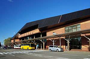
Tokachi–Obihiro Airport
For the former Obihiro Airport, see Tokachi Airfield.
| Tokachi–Obihiro Airport とかち帯広空港 | |||||||||||
|---|---|---|---|---|---|---|---|---|---|---|---|
 | |||||||||||
| IATA: OBO – ICAO: RJCB | |||||||||||
| Summary | |||||||||||
| Airport type | Public | ||||||||||
| Serves | Obihiro, Hokkaidō, Japan | ||||||||||
| Elevation AMSL | 490 ft / 149 m | ||||||||||
| Coordinates | 42°44′00″N 143°13′02″E / 42.73333°N 143.21722°ECoordinates: 42°44′00″N 143°13′02″E / 42.73333°N 143.21722°E | ||||||||||
| Website | obihiro-airport.com | ||||||||||
| Map | |||||||||||
 RJCB Location in Japan 42°44′00″N 143°13′02″E / 42.73333°N 143.21722°E | |||||||||||
| Runways | |||||||||||
| |||||||||||
| Statistics (2014) | |||||||||||
| |||||||||||
Tokachi–Obihiro Airport (とかち帯広空港 Tokachi-Obihiro Kūkō, or sometimes simply Obihiro Airport) (IATA: OBO, ICAO: RJCB) is an airport located 13.5 NM (25.0 km; 15.5 mi) south of Obihiro Station in Obihiro, Hokkaidō, Japan.[1]
Airlines and destinations
| Airlines | Destinations |
|---|---|
| Air Do | Tokyo–Haneda |
| All Nippon Airways | Osaka-Kansai |
| Hokkaido Air System | Sapporo-Okadama |
| Japan Airlines | Tokyo–Haneda |
| Juneyao Airlines | Shanghai-Pudong[3] |
History
The airport opened in March 1981, initially with a 2,000 m (6,562 ft) runway, taking over the role of the former Obihiro Airport, now Tokachi Airfield. The runway was extended to 2,500 m in November 1985.[4]
References
- 1 2 AIS Japan
- ↑ "Obihiro Airport Statistics" (PDF) (Press release). Ministry of Land, Infrastructure, Transport and Tourism. Retrieved 8 July 2016.
- ↑ http://airlineroute.net/2016/01/14/ho-pvgobo-jan16/
- ↑ Ministry of Land,Infrastructure and Transport Hokkaido Regional Development Bureau: Obihiro Airport history Retrieved on 7 August 2009 (Japanese)
External links
| Wikimedia Commons has media related to Obihiro Airport. |
- Official website (Japanese)
- Terminal Building(Japanese)
1 Joint civil-military use | |||||||||||
| Major hubs | |||||||||||
| International |
| ||||||||||
| Domestic |
| ||||||||||
| General aviation |
| ||||||||||
| Military | |||||||||||
| Heliports |
| ||||||||||
| Defunct | |||||||||||
Mass transit in Hokkaido | |
|---|---|
| JR named trains | |
| Other railways | |
| Terminals |
|
| Public Ferries |
|
| Miscellaneous |
|
| |
This article is issued from Wikipedia - version of the 12/4/2016. The text is available under the Creative Commons Attribution/Share Alike but additional terms may apply for the media files.