Tomakomai, Hokkaido
| Tomakomai 苫小牧市 | ||
|---|---|---|
| City | ||
| ||
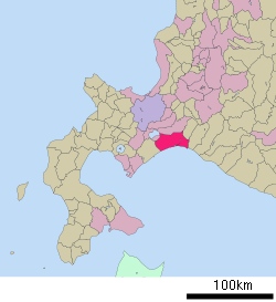 Location of Tomakomai in Hokkaido (Iburi Subprefecture) | ||
 Tomakomai Location in Japan | ||
| Coordinates: 42°38′N 141°36′E / 42.633°N 141.600°ECoordinates: 42°38′N 141°36′E / 42.633°N 141.600°E | ||
| Country | Japan | |
| Region | Hokkaido | |
| Prefecture | Hokkaido (Iburi Subprefecture) | |
| Government | ||
| • Mayor | Hirofumi Iwakura | |
| Area | ||
| • Total | 561.49 km2 (216.79 sq mi) | |
| Population (February 29, 2012) | ||
| • Total | 174,216 | |
| • Density | 310.27/km2 (803.6/sq mi) | |
| Symbols | ||
| • Tree | Japanese Rowan | |
| • Flower |
Tree flower: Hasukappu (Lonicera caerulea var. emphyllocalyx) Grass flower: Hanashōbu (Iris ensata var. ensata) | |
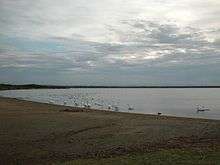
| • Bird | Swan | |
| • Others | Shell: Sakhalin surf clam (Pseudocardium sachalinense) | |
| Time zone | Japan Standard Time (UTC+9) | |
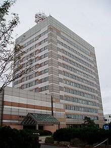
| City hall address |
4-5-6 Asahimachi, Tomakomai-shi, Hokkaido 053-8722 | |
| Website |
www | |

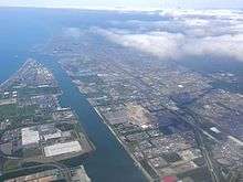
Tomakomai (苫小牧市 Tomakomai-shi) is a city and port in Iburi Subprefecture, Hokkaido, Japan. It is the largest city in the Iburi Subprefecture and the fifth largest city in Hokkaido.
As of February 29, 2012, it had an estimated population of 174,216, with 83,836 households and a population density of 310.27 persons per km² (803.60 persons per sq. mi.). The total area is 561.49 km2 (216.79 sq mi).
History
The name of Tomakomai is derived from Ainu word "to" and "mak oma nay", meaning "Marsh" and "River which goes into the depths of the mountain".[1][2]
- 1873 The village of Tomakomai was founded.
- 1918 Tomakomai village became Tomakomai town.
- 1948 Tomakomai town became Tomakomai city.
Geography
Mount Tarumae is located in the northwest of Tomakomai and belongs to Shikotsu-Tōya National Park.
Climate
Tomokomai has a humid continental climate typical of Hokkaido.
| Climate data for Tomakomai (1981–2010) | |||||||||||||
|---|---|---|---|---|---|---|---|---|---|---|---|---|---|
| Month | Jan | Feb | Mar | Apr | May | Jun | Jul | Aug | Sep | Oct | Nov | Dec | Year |
| Average high °C (°F) | 0.2 (32.4) |
0.5 (32.9) |
3.8 (38.8) |
9.2 (48.6) |
13.5 (56.3) |
16.7 (62.1) |
20.3 (68.5) |
23.1 (73.6) |
21.2 (70.2) |
15.8 (60.4) |
8.9 (48) |
2.8 (37) |
11.3 (52.4) |
| Average low °C (°F) | −8.3 (17.1) |
−8.1 (17.4) |
−3.9 (25) |
1.2 (34.2) |
6.2 (43.2) |
11.1 (52) |
15.6 (60.1) |
18.0 (64.4) |
13.3 (55.9) |
6.1 (43) |
0.1 (32.2) |
−5.3 (22.5) |
3.8 (38.9) |
| Average precipitation mm (inches) | 40.0 (1.575) |
33.7 (1.327) |
51.9 (2.043) |
79.7 (3.138) |
119.5 (4.705) |
95.8 (3.772) |
167.9 (6.61) |
205.0 (8.071) |
167.3 (6.587) |
103.5 (4.075) |
82.9 (3.264) |
50.9 (2.004) |
1,198.1 (47.171) |
| Average snowfall cm (inches) | 39 (15.4) |
39 (15.4) |
27 (10.6) |
4 (1.6) |
0 (0) |
0 (0) |
0 (0) |
0 (0) |
0 (0) |
0 (0) |
4 (1.6) |
27 (10.6) |
140 (55.2) |
| Average precipitation days (≥ 0.5 mm) | 7.2 | 7.1 | 9.1 | 8.4 | 9.4 | 8.5 | 11.2 | 11.1 | 10.1 | 9.2 | 9.0 | 8.2 | 108.5 |
| Average snowy days | 24.6 | 24.6 | 14.2 | 1.2 | 0 | 0 | 0 | 0 | 0 | 0.1 | 1.5 | 13.5 | 79.7 |
| Average relative humidity (%) | 70 | 70 | 71 | 75 | 79 | 88 | 86 | 79 | 73 | 69 | 68 | 76 | 75.3 |
| Mean monthly sunshine hours | 141.3 | 141.2 | 165.7 | 171.0 | 171.7 | 123.3 | 98.4 | 118.9 | 153.3 | 163.1 | 129.1 | 126.2 | 1,703.2 |
| Source: Japan Meteorological Agency | |||||||||||||
Transportation
Airport
Rail
- Muroran Main Line : Nishikioka - Itoi - Aoba - Tomakomai - Numanohata
- Chitose Line : Numanohata - Uenae
- Hidaka Main Line : Numanohata - Yūfutsu
Road
- Hokkaidō Expressway
- Hidaka Expressway
Education
University
College
- National Institute of Technology, Tomakomai College
High Schools
Public
- Hokkaido Tomakomai Higashi High School
- Hokkaido Tomakomai Minami High School
- Hokkaido Tomakomai Nishi High School
- Hokkaido Tomakomai Technical High School
- Hokkaido Tomakomai Sogokeizai High School
Private
- Tomakomai Chuo High School
- Komazawa University Tomakomai High School
Sports
In 2014, Tomakomai will host the World Broomball championships.[3]
Sister cities and friendship city
Sister cities
-
 Hachioji, Tokyo, Japan (since 1973)[4]
 -
 Napier, Hawke's Bay Region, New Zealand (since 1980)
 - Nikko, Tochigi, Japan (since 1982)
Friendship city
-
 Qinhuangdao, Hebei, China (since 1998)
Notable people from Tomakomai
- Asami Kimura, singer in Hello! Project and former Country Musume member and leader
- Eiichi Kudo, film director
- Junko Misaki, enka-singer
- Kei Sanbe, manga artist[5]
- Naoki Sano, professional wrestler
- Hisayoshi Sato, swimmer[6]
References
- ↑ The outline of Tomakomai
- ↑ The history of Tomakomai
- ↑ "2014 – IFBA World Broomball Championship, Tomakomai, Japan (December Update)". IFBA. 14 December 2013. Retrieved 7 January 2014.
- ↑ Sister cities and friendship city of Tomakomai
- ↑ "Kei Sanbe". Anime News Network. Retrieved 29 January 2016.
- ↑ "Hisayoshi Sato". sports-reference.com. Retrieved 19 April 2014.
External links
| Wikimedia Commons has media related to Tomakomai, Hokkaido. |
- Official website (English)